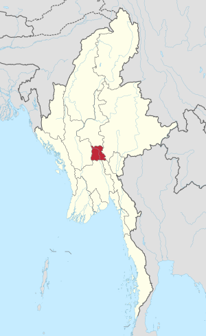
Country:
 Myanmar (Burma)
Region:
City:
Latitude and Longitude:
Time Zone:
Postal Code:
IP information under different IP Channel
ip-api
Country
Region
City
ASN
Time Zone
ISP
Blacklist
Proxy
Latitude
Longitude
Postal
Route
IPinfo
Country
Region
City
ASN
Time Zone
ISP
Blacklist
Proxy
Latitude
Longitude
Postal
Route
MaxMind
Country
Region
City
ASN
Time Zone
ISP
Blacklist
Proxy
Latitude
Longitude
Postal
Route
Luminati
Country
MMASN
Time Zone
Asia/Yangon
ISP
OOREDOO MYANMAR
Latitude
Longitude
Postal
db-ip
Country
Region
City
ASN
Time Zone
ISP
Blacklist
Proxy
Latitude
Longitude
Postal
Route
ipdata
Country
Region
City
ASN
Time Zone
ISP
Blacklist
Proxy
Latitude
Longitude
Postal
Route
Popular places and events near this IP address

Mandalay University
Arts and science university in Myanmar
Distance: Approx. 270 meters
Latitude and longitude: 21.95833333,96.09166667
Mandalay University (also translated as University of Mandalay; Burmese: မန္တလေးတက္ကသိုလ် [màɰ̃dəlé tɛʔkəθò]) is a public liberal arts and science university located in Mandalay, Myanmar and one of the sixteen autonomous universities under Ministry of Education. Formerly an affiliate of Rangoon University, Mandalay University is the second oldest university in Myanmar, and the oldest and largest university in Upper Myanmar. The university offers mainly undergraduate and postgraduate degree programmes (Bachelor's, Master's, Post-graduate Diploma, and Doctorate) in liberal arts, sciences and law.

Mahamuni Buddha Temple
Buddhist temple in Mandalay, Myanmar
Distance: Approx. 1329 meters
Latitude and longitude: 21.95186944,96.07861944
The Mahamuni Buddha Temple (Burmese: မဟာမုနိရှင်တော်မြတ်ကြီး, Burmese pronunciation: [məhà mṵnḭ pʰəjádʑí]) is a Buddhist temple and major pilgrimage site, located southwest of Mandalay, Myanmar (Burma). The Mahamuni Image (lit. 'The Great Sage') is enshrined in this temple, and originally came from Arakan. It is highly venerated in Burma and central to many people's lives, as it is seen as an expression of representing the Buddha's life.

Maha Aungmye Township
Township of Mandalay in Burma
Distance: Approx. 1146 meters
Latitude and longitude: 21.95,96.08333333
Maha Aungmye Township (Burmese: မဟာအောင်မြေ မြို့နယ် [məhà àʊɰ̃ mjè mjo̰nɛ̀], also known as Mahaaungmye Township) is located immediately south of downtown Mandalay, Myanmar. It is the major residential area of Mandalay. The township is bounded by the Ayeyarwady river in the west, Chanayethazan Township in the north, Chanmyathazi Township in the south.

Chanayethazan Township
Township of Mandalay in Myanmar
Distance: Approx. 1059 meters
Latitude and longitude: 21.96666667,96.08333333
Chanayethazan Township (Burmese: ချမ်းအေးသာစံ မြို့နယ်, pronounced [tɕʰáɰ̃ ʔé θà zàɰ̃ mjo̰nɛ̀]) is a township located in downtown Mandalay, Myanmar. The township is bounded by Aungmyethazan Township and the Mandalay Palace in the north, and Patheingyi Township in the east, Maha Aungmye Township in the south, and the Ayeyarwady river in the west. Chanayethazan is the main business district of the city.

Mandalay District
Former district of Mandalay Region in Myanmar
Distance: Approx. 1059 meters
Latitude and longitude: 21.96666667,96.08333333
Mandalay District (Burmese: မန္တလေး ခရိုင်) was a district of the Mandalay Region in central Myanmar. Though the district used to consist of two cities, Mandalay and Amarapura, today, with the urban sprawl of Mandalay capturing Amarapura and Patheingyi, the district and the city of Mandalay are one and the same. The district was dissolved and formed as Aungmyethazan District, Maha Aungmye District and Amarapura District on 30 April 2022.
Naypyidaw Union Territory
Union territory of Myanmar
Distance: Approx. 1059 meters
Latitude and longitude: 21.96666667,96.08333333
The Naypyitaw Union Territory (Burmese: ပြည်ထောင်စုနယ်မြေ နေပြည်တော်), also called Naypyitaw Council Territory (နေပြည်တော်ကောင်စီနယ်မြေ) (Naypyitaw also spelled Nay Pyi Taw, Naypyidaw or Nay Pyi Daw) is an administrative division in central Myanmar (Burma). It contains Naypyidaw, the capital city of Myanmar.
Yadanabon Market
Market in Mandalay, Myanmar
Distance: Approx. 1416 meters
Latitude and longitude: 21.971422,96.087434
Yadanabon Market (Burmese: ရတနာပုံဈေး) is Mandalay's second-largest market. It is between 77th and 33rd and 34th streets, near the Mandalay Central Railway Station. The market is now beside the Diamond Plaza.

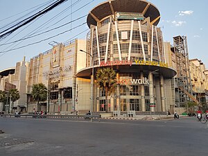
Diamond Plaza (Mandalay)
Shopping Centre in bet. and streets, Chanaye Thazan
Distance: Approx. 1486 meters
Latitude and longitude: 21.9715883,96.0849588
Diamond Plaza (Burmese: ဒိုင်းမွန်း ပလာဇာ) is one of the biggest shopping centres, located in downtown Mandalay near the Mandalay Central Railway Station. The complex consists of two towers: Tower A (Diamond Plaza) and Tower B (Yadanabon Super Centre).

Maha Min Htin Monastery
Distance: Approx. 709 meters
Latitude and longitude: 21.953979,96.084614
Maha Min Htin Monastery (Burmese: မဟာမင်းထင်ကျောင်း) is a historic Buddhist monastery in Mandalay, Burma. The monastery was established in 1852, donated by Maha Minhla Minkyaw U Min Htin and is located near the Mahamuni Buddha Temple. It was originally built in Inwa and was moved to Mandalay in 1876.

Maha Aungmye Bonzan Monastery
Distance: Approx. 1868 meters
Latitude and longitude: 21.965789,96.072651
Maha Aungmye Bonzan Monastery (Burmese: မဟာအောင်မြေဘုံစံကျောင်း), commonly known as the Me Nu Brick Monastery (Burmese: မယ်နုအုတ်ကျောင်း), is a historic Buddhist monastery in Inwa, Mandalay Region, Myanmar (formerly Burma). The monastery was built by Queen Nanmadaw Me Nu in 1818 to serve as the residence of her religious preceptor, the Nyaunggan Sayadaw U Po. Then offered to the 2nd Nyaunggan Sayardaw U Bok.
Grand Park Hotel, Mandalay
Hotel in Maha Aungmye, Mandalay
Distance: Approx. 1590 meters
Latitude and longitude: 21.9625487,96.0742378
Grand Park Hotel is a hotel located in downtown Mandalay, Myanmar. The 31-story tower is the tallest building in the country outside of Yangon. The hotel was partially opened, with 302 rooms available in September 2019, and with another 92 rooms to be ready by December 2019.

Mandalay Convention Centre
Convention Center in Myanmar
Distance: Approx. 1146 meters
Latitude and longitude: 21.9513,96.0967
Mandalay Convention Centre (Burmese: မန္တလေးကွန်ဗင်ရှင်းစင်တာ) is a convention centre in Mandalay.Construction began under the time of Mayor Aung Maung and opened on November 9, 2018, under Ye Lwin. It is one of four convention centers in Myanmar.
Weather in this IP's area
clear sky
30 Celsius
35 Celsius
30 Celsius
30 Celsius
1005 hPa
74 %
1005 hPa
996 hPa
10000 meters
1.61 m/s
2.02 m/s
169 degree
6 %
05:53:37
18:05:22