Country:
 Nigeria
Region:
City:
Latitude and Longitude:
Time Zone:
Postal Code:
IP information under different IP Channel
ip-api
Country
Region
City
ASN
Time Zone
ISP
Blacklist
Proxy
Latitude
Longitude
Postal
Route
IPinfo
Country
Region
City
ASN
Time Zone
ISP
Blacklist
Proxy
Latitude
Longitude
Postal
Route
MaxMind
Country
Region
City
ASN
Time Zone
ISP
Blacklist
Proxy
Latitude
Longitude
Postal
Route
Luminati
Country
NGRegion
la
City
lagos
ASN
Time Zone
Africa/Lagos
ISP
LLNW
Latitude
Longitude
Postal
db-ip
Country
Region
City
ASN
Time Zone
ISP
Blacklist
Proxy
Latitude
Longitude
Postal
Route
ipdata
Country
Region
City
ASN
Time Zone
ISP
Blacklist
Proxy
Latitude
Longitude
Postal
Route
Popular places and events near this IP address
2006 Lagos building collapses
Lagos building collapses in 2006
Distance: Approx. 812 meters
Latitude and longitude: 6.453,3.395
In 2006, up to 3 building collapses were reported in Lagos, Nigeria.

Lagos Colony
British protectorate from 1862 to 1906
Distance: Approx. 878 meters
Latitude and longitude: 6.45305556,3.39583333
Lagos Colony was a British colonial possession centred on the port of Lagos in what is now southern Nigeria. Lagos was annexed on 6 August 1861 under the threat of force by Commander Beddingfield of HMS Prometheus who was accompanied by the Acting British Consul, William McCoskry. Oba Dosunmu of Lagos (spelled "Docemo" in British documents) resisted the cession for 11 days while facing the threat of violence on Lagos and its people, but capitulated and signed the Lagos Treaty of Cession.

NECOM House
Skyscraper located in Lagos
Distance: Approx. 818 meters
Latitude and longitude: 6.4462161,3.3975961
NECOM House (formerly NITEL Tower and before that, the NET Building) is a skyscraper located in Lagos. The 32-story building was completed in 1979, and houses the headquarters of NITEL. The communications spire at the top of the tower serves as a lighthouse beacon for Lagos Harbour. The building is constructed of concrete.
Union Bank Building (Lagos)
Skyscraper in Lagos
Distance: Approx. 614 meters
Latitude and longitude: 6.4523794,3.38792252
Union Bank Building is a skyscraper in Lagos. The 28-story building serves as the headquarters of the Union Bank of Nigeria.

Cathedral Church of Christ, Lagos
Church in Lagos, Nigeria
Distance: Approx. 379 meters
Latitude and longitude: 6.4508,3.3902
The Cathedral Church of Christ Marina, Lagos is an Anglican cathedral on Lagos Island, Lagos, Nigeria.
Lagos Island General Hospital
Hospital in Lagos State, Nigeria
Distance: Approx. 719 meters
Latitude and longitude: 6.4474,3.3968
General Hospital, Lagos, is the oldest hospital in Nigeria.

Freedom Park (Lagos)
Public park in Lagos, Nigeria
Distance: Approx. 706 meters
Latitude and longitude: 6.4489,3.3965
Freedom Park is a memorial and leisure park area in the middle of downtown Lagos in Lagos Island, Nigeria which was formerly Her Majesty's Broad Street Prison. It was designed by the architect Theo Lawson as a speculative project under the CIA-Lagos (formerly the Creative Intelligence Agency and now the Cultural Intellectual Association) in 1999. The park was constructed to preserve the history and cultural heritage of Nigerians.
Ajele Cemetery
Former cemetery in Nigeria
Distance: Approx. 628 meters
Latitude and longitude: 6.4515,3.3942
Ajele Cemetery was a major cemetery on Lagos Island demolished by the Lagos State military government under Brigadier Mobolaji Johnson in the 1970s. Ajele in Yoruba means government administrative official and the cemetery was so named because of the many British colonial officials who were buried there.

Holy Cross Cathedral, Lagos
Church in Lagos, Nigeria
Distance: Approx. 750 meters
Latitude and longitude: 6.4499,3.3966
Holy Cross Cathedral is a Roman Catholic cathedral located in Lagos, Nigeria, and is the seat of the Archdiocese of Lagos. The Gothic style building was constructed in 1939, when the region was still administered as an apostolic vicariate, and thus was only elevated to the status of cathedral in 1950.
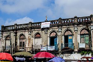
Ilojo Bar
Brazilian-styled historic building
Distance: Approx. 719 meters
Latitude and longitude: 6.45385,3.38997
Ilojo Bar, also called Olaiya House or Casa da Fernandez, was a Brazilian-styled historic building located near Tinubu Square in Lagos Island, Lagos State, Nigeria. It was originally built as a bar and restaurant in 1855 by the Fernandez family who employed returning ex-slaves who had mastered the art of building while in South America. Ilojo Bar was subsequently sold to Alfred Omolana Olaiya of the Olaiya family in 1933 and was declared a national monument in 1956 by the National Commission for Museums and Monuments.

Tinubu Square
Landmark in Lagos, Nigeria
Distance: Approx. 719 meters
Latitude and longitude: 6.4538,3.3894
Tinubu Square, formerly Independence Square, is an open space landmark located in Broad Street, Lagos Island, Lagos State, Nigeria named after the Yoruba slave trader, merchant, and aristocrat Madam Efunroye Tinubu. It was formerly called Ita Tinubu before it was named Independence Square by leaders of the First Nigerian Republic after Nigerian independence and subsequently Tinubu Square.
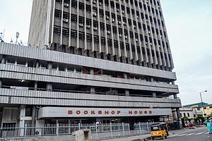
Bookshop House
Historical building in Lagos Island
Distance: Approx. 525 meters
Latitude and longitude: 6.452072,3.3909398
Bookshop House (also called CSS Bookshop) is a building in the Lagos Island located at Northeastern part of Broad street at Odunlami street. It was designed by Godwin and Hopwood Architects and built in 1973.
Weather in this IP's area
scattered clouds
25 Celsius
26 Celsius
25 Celsius
25 Celsius
1014 hPa
94 %
1014 hPa
1014 hPa
7000 meters
1.54 m/s
310 degree
40 %
06:36:50
18:45:46