Country:
 India
IndiaRegion:
City:
Latitude and Longitude:
Time Zone:
Postal Code:
IP information under different IP Channel
ip-api
Country
Region
City
ASN
Time Zone
ISP
Blacklist
Proxy
Latitude
Longitude
Postal
Route
IPinfo
Country
Region
City
ASN
Time Zone
ISP
Blacklist
Proxy
Latitude
Longitude
Postal
Route
MaxMind
Country
Region
City
ASN
Time Zone
ISP
Blacklist
Proxy
Latitude
Longitude
Postal
Route
Luminati
Country
 ZA
ZAASN
Time Zone
Africa/Johannesburg
ISP
LLNW
Latitude
Longitude
Postal
db-ip
Country
Region
City
ASN
Time Zone
ISP
Blacklist
Proxy
Latitude
Longitude
Postal
Route
ipdata
Country
Region
City
ASN
Time Zone
ISP
Blacklist
Proxy
Latitude
Longitude
Postal
Route
Popular places and events near this IP address
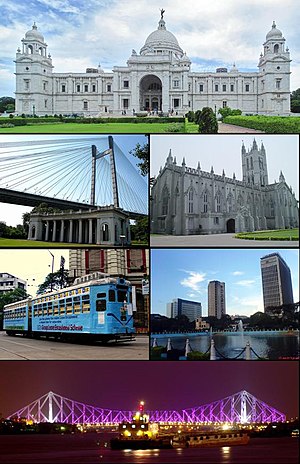
Kolkata district
District in West Bengal, India
Distance: Approx. 8 meters
Latitude and longitude: 22.5726723,88.3638815
Kolkata district (formerly known as Calcutta district) is a district in the Indian state of West Bengal. It only contains the entire city proper of Kolkata, the capital city of the state and therefore it is a city district. It is the smallest district in the state and also the most densely populated district.

Geography of Kolkata
Distance: Approx. 8 meters
Latitude and longitude: 22.5726723,88.3638815
Kolkata is located in the eastern part of India. It has spread linearly along the banks of the Hooghly River. The Kolkata Municipal Corporation has an area of 205 square kilometres.
Calcutta North West Lok Sabha constituency
Former Constituency of the Indian parliament in West Bengal
Distance: Approx. 8 meters
Latitude and longitude: 22.5726723,88.3638815
Calcutta North West Lok Sabha constituency was one of the 543 parliamentary constituencies in India. The constituency centred on the north-western part of Calcutta in West Bengal. As a consequence of the order of the Delimitation Commission in respect of the delimitation of constituencies in the West Bengal, this parliamentary constituency ceased to exist from 2009.

Kolkata Dakshin Lok Sabha constituency
Lok Sabha Constituency in West Bengal, India
Distance: Approx. 8 meters
Latitude and longitude: 22.5726723,88.3638815
Kolkata Dakshin Lok Sabha constituency (earlier known as Calcutta South Lok Sabha constituency) is one of the 543 Lok Sabha (parliamentary) constituencies in India. The constituency centres on the southern part of Kolkata in West Bengal. While four of the seven legislative assembly segments on No.

Presidency division
Division in West Bengal, India
Distance: Approx. 8 meters
Latitude and longitude: 22.5726723,88.3638815
Presidency division is an administrative division within the Indian state of West Bengal. The headquarters and the largest city of the Presidency division is Kolkata, the state capital. Presidency division is bounded by Medinipur division to South-West, Burdwan division to North-West and Malda division to North.
Calcutta North East Lok Sabha constituency
Former Constituency of the Indian parliament in West Bengal
Distance: Approx. 8 meters
Latitude and longitude: 22.5726723,88.3638815
Calcutta North East Lok Sabha constituency was one of the 543 parliamentary constituencies in India. The constituency centred on North East area of Kolkata in West Bengal. As a consequence of the order of the Delimitation Commission in respect of the delimitation of constituencies in the West Bengal, this parliamentary constituency ceased to exist from 2009.

Kolkata Uttar Lok Sabha constituency
Lok Sabha constituency in West Bengal
Distance: Approx. 8 meters
Latitude and longitude: 22.5726723,88.3638815
Kolkata Uttar Lok Sabha constituency is one of the 543 parliamentary constituencies in India. The constituency is based on the northern parts of Kolkata in West Bengal. All the seven assembly segments of No.
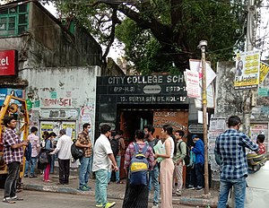
City College of Commerce and Business Administration
Undergraduate college in Kolkata, India
Distance: Approx. 137 meters
Latitude and longitude: 22.5738188,88.3637211
The City College of Commerce & Business Administration is an undergraduate commerce college in Kolkata, India. It is affiliated with the University of Calcutta. It was established in 1961 by the Brahmo Arya Samaj Society, offering only B.COM Honours & Pass with a specialization in Accountancy & Finance/Marketing programmes for undergraduates.
East Kolkata
Neighborhood in Kolkata in Kolkata Metropolitan Area, West Bengal, India
Distance: Approx. 8 meters
Latitude and longitude: 22.5726723,88.3638815
East Kolkata refers to the eastern areas of the city of Kolkata, India. It includes the localities of Metropolitan Township, Dhapa, Tangra, Bantala, Topsia, Tiljala, VIP Nagar, Anandapur, Kalikapur, Mukundapur, Ajoy Nagar, Panchasayar and certain parts of Garia like Baishnabghata-Patuli Township, Chak Garia, Nayabad and New Garia. The northern part of East Kolkata is dominated by the townships of Salt Lake and New Town.

North Kolkata
Neighborhood in Kolkata
Distance: Approx. 8 meters
Latitude and longitude: 22.5726723,88.3638815
North Kolkata encompasses the northern part of Kolkata, including the city's oldest neighborhoods. Notable areas within North Kolkata include Shyambazar, Bagbazar, Kumartuli, Shobhabazar, Posta, Jorasanko, Rajabazar, Phoolbagan, Maniktala, Kankurgachi, Ultadanga, Chitpur, Belgachia, Tala, Sinthee, Cossipore and Baranagar. This region is known for its old heritage buildings and temples, such as the Shovabazar Rajbari.
Calcutta South East Lok Sabha constituency
Former Constituency of the Indian parliament in West Bengal
Distance: Approx. 8 meters
Latitude and longitude: 22.5726723,88.3638815
Calcutta South East was a constituency of the Lok Sabha (Lower House of the Parliament of India), located in the city of Calcutta, West Bengal. It was used in the parliamentary election of 1951–1952 as well as in a 1953 by-election. The constituency elected a single member of the Lok Sabha.
Calcutta East Lok Sabha constituency
Former Constituency of the Indian parliament in West Bengal
Distance: Approx. 8 meters
Latitude and longitude: 22.5726723,88.3638815
Calcutta East was a constituency of the Lok Sabha (Lower House of the Parliament of India), located in the city of Calcutta, West Bengal. It was used in the 1957 Indian general election and 1962 Indian general election. As of 1957, the constituency had 497,202 eligible voters.
Weather in this IP's area
heavy intensity rain
27 Celsius
31 Celsius
27 Celsius
27 Celsius
1001 hPa
89 %
1001 hPa
999 hPa
2600 meters
5.66 m/s
130 degree
100 %
05:23:37
17:39:22