Country:
 India
IndiaRegion:
City:
Latitude and Longitude:
Time Zone:
Postal Code:
IP information under different IP Channel
ip-api
Country
Region
City
ASN
Time Zone
ISP
Blacklist
Proxy
Latitude
Longitude
Postal
Route
IPinfo
Country
Region
City
ASN
Time Zone
ISP
Blacklist
Proxy
Latitude
Longitude
Postal
Route
MaxMind
Country
Region
City
ASN
Time Zone
ISP
Blacklist
Proxy
Latitude
Longitude
Postal
Route
Luminati
Country
 ZA
ZAASN
Time Zone
Africa/Johannesburg
ISP
LLNW
Latitude
Longitude
Postal
db-ip
Country
Region
City
ASN
Time Zone
ISP
Blacklist
Proxy
Latitude
Longitude
Postal
Route
ipdata
Country
Region
City
ASN
Time Zone
ISP
Blacklist
Proxy
Latitude
Longitude
Postal
Route
Popular places and events near this IP address
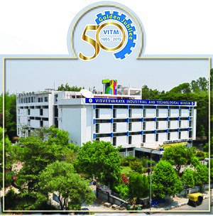
Visvesvaraya Industrial and Technological Museum
Science museum in Bangalore, India
Distance: Approx. 436 meters
Latitude and longitude: 12.9751,77.5964
The Visvesvaraya Industrial and Technological Museum (VITM), Bangalore, India, a constituent unit of the National Council of Science Museums (NCSM), Ministry of Culture, Government of India, was established in memory of Sir M. Visvesvaraya. The 4,000 m2 (43,000 sq ft) building was constructed in Cubbon Park, and was inaugurated by the first Prime Minister of India, Pandit Jawaharlal Nehru, on July 14, 1962. The museum displays industrial products, scientific models and engines.

Sree Kanteerava Stadium
Sports stadium in Bengaluru, India
Distance: Approx. 248 meters
Latitude and longitude: 12.9697,77.5934
Sree Kanteerava Outdoor Stadium, also known as Sampangi Outdoor Stadium, is a multi-purpose stadium in Bangalore, India. It houses a running track, a volleyball court, and two outdoor rock climbing walls. The stadium is owned by the Department of Youth Empowerment and Sports, Government of Karnataka.
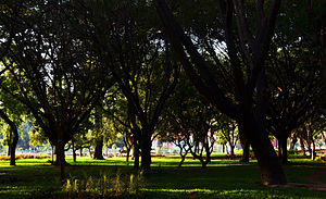
Sri Chamarajendra Udyanavana
Neighbourhood in Bengaluru Urban, Karnataka, India
Distance: Approx. 403 meters
Latitude and longitude: 12.975,77.59333333
Cubbon Park, officially Sri Chamarajendra Park, is a landmark park in Bengaluru, located in the heart of the city in the Central Administrative Area. Originally created in 1870 under Major General Richard Sankey, then British Chief Engineer of Mysore State, it covered an area of 100 acres (0.40 km2). Subsequent expansion has since taken place and the park's area is now reported to be 300 acres (1.2 km2).
St. Joseph's Indian High School
School in Bangalore, Karnataka, India
Distance: Approx. 213 meters
Latitude and longitude: 12.96972222,77.595
St. Joseph's Indian High School is a private Catholic primary and secondary school and private pre-university and community college located in Bangalore, in the state of Karnataka, India. It traces its origins to a secondary school founded by the Paris Foreign Missions Society in 1904 on St.
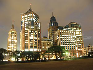
UB City
Business District in Karnataka, India
Distance: Approx. 135 meters
Latitude and longitude: 12.97175,77.59583333
UB City is a business district in Bengaluru, India. It consists of 6 blocks with a total built up area of over 1.6 million sq ft. Pioneered by the UB Group in a joint venture with Prestige Group, it is built on 13 acres (53,000 m2) of land and hosts 1,000,000 sq ft (93,000 m2) of high-end commercial, retail and service apartment space.
Adagodi
Village in Karnataka, India
Distance: Approx. 4 meters
Latitude and longitude: 12.9715987,77.5945627
Adagodi is a village in Shimoga district, Karnataka, India. It is located in the Hosanagara taluk.
Lavelle Road
Neighbourhood in Bengaluru City, Karnataka, India
Distance: Approx. 357 meters
Latitude and longitude: 12.9711522,77.5978612
Lavelle Road is an upmarket residential and commercial street in the city of Bangalore, Karnataka in India. It is an important connection between Mahatma Gandhi Square and Richmond Circle. The road starts from the Queens Road end of the M. Chinnaswamy Stadium and after curving in a serpentine manner meets the junction of Bangalore Club with Richmond Circle.
St. Paul's Church, Bangalore
Church in Bangalore, India
Distance: Approx. 4 meters
Latitude and longitude: 12.9715987,77.5945627
St. Paul's Church is located in the corner of Old Poor House Road, and Bowring Hospital Road, next to the Bowring and Lady Curzon Hospital, Bangalore Cantonment, India. St.
Kasturba Road
Street in Bangalore, Karnataka, India
Distance: Approx. 106 meters
Latitude and longitude: 12.971907,77.593679
Kasturba Road is a street in Bangalore, the capital of Karnataka, India, which is connected to M G Road to the north and J C Road to the south. Some important landmarks situated along Kasturba Road are Sree Kanteerava Stadium, Kanteerava Indoor Stadium, Cubbon Park, Government Museum, Venkatappa Art Gallery, Visvesvaraya Industrial and Technological Museum and UB City. A 600-year-old Ganesha temple is also situated on Kasturba Road.

Venkatappa Art Gallery
Distance: Approx. 303 meters
Latitude and longitude: 12.9742357,77.5953023
Venkatappa Art Gallery (VAG) is situated in Bangalore, India, in the vicinity of Cubbon Park and next to the Bangalore Museum as well as the Visvesvaraya Industrial and Technological Museum. It attracts artists and art lovers from all over Karnataka.
St. Joseph's Community College, Bangalore
Distance: Approx. 270 meters
Latitude and longitude: 12.96923889,77.59515278
St. Joseph's Community College was founded in 2005 by the Society of Jesus and shares a campus with St. Joseph's Indian High School in Bangalore, India.

Museum of Art & Photography
Art museum based in Bangalore, India
Distance: Approx. 408 meters
Latitude and longitude: 12.9745,77.5969
The Museum of Art and Photography (MAP) is a private art museum based in Bangalore, India that is a custodian to a collection of Indian art, textiles, photography, craft, and design objects spanning from the twelfth century to the present. MAP opened its doors to the public on 18 February 2023 as a private art museum. In December 2020, MAP launched a digital museum, that offers a virtual interactive experience to viewers.
Weather in this IP's area
scattered clouds
28 Celsius
29 Celsius
27 Celsius
29 Celsius
1009 hPa
59 %
1009 hPa
912 hPa
8000 meters
6.17 m/s
290 degree
40 %
06:08:47
18:20:20