Country:
 India
IndiaRegion:
City:
Latitude and Longitude:
Time Zone:
Postal Code:
IP information under different IP Channel
ip-api
Country
Region
City
ASN
Time Zone
ISP
Blacklist
Proxy
Latitude
Longitude
Postal
Route
IPinfo
Country
Region
City
ASN
Time Zone
ISP
Blacklist
Proxy
Latitude
Longitude
Postal
Route
MaxMind
Country
Region
City
ASN
Time Zone
ISP
Blacklist
Proxy
Latitude
Longitude
Postal
Route
Luminati
Country
 ZA
ZAASN
Time Zone
Africa/Johannesburg
ISP
LLNW
Latitude
Longitude
Postal
db-ip
Country
Region
City
ASN
Time Zone
ISP
Blacklist
Proxy
Latitude
Longitude
Postal
Route
ipdata
Country
Region
City
ASN
Time Zone
ISP
Blacklist
Proxy
Latitude
Longitude
Postal
Route
Popular places and events near this IP address

Osmania Medical College
Medical college in Telangana, Hyderabad, India
Distance: Approx. 391 meters
Latitude and longitude: 17.38214722,78.48454722
Osmania Medical College, formerly known as Hyderabad Medical School, is a public medical college in Hyderabad, Telangana, India. It was founded in 1846 by the 5th Nizam of Hyderabad and Berar, Afzal ud Dowla, Asaf Jah V. The college was originally affiliated to Osmania University system, now it is affiliated to the Kaloji Narayana Rao University of Health Sciences, and the Osmania General Hospital. After the establishment of the Osmania University in 1919, the school was renamed Osmania Medical College, after the seventh Nizam of Hyderabad, Mir Osman Ali Khan.

Koti, Hyderabad
Inner City in Telangana, India
Distance: Approx. 326 meters
Latitude and longitude: 17.38564,78.48371
Koti (or Kothi) is a locality in the city of Hyderabad, Telangana, India. It is one of the best-known commercial old suburbs of Hyderabad. There are two areas in the vicinity: King Koti and Ram Koti.

Sultan Bazar
Inner City in Telangana, India
Distance: Approx. 403 meters
Latitude and longitude: 17.38333333,78.48333333
Sultan Bazar is an old commercial market in Hyderabad, Telangana, India. It lies between the commercial areas of Abids and Koti. It was previously known as the residency bazaar.

Sanjeevaiah Park
Public park in Hyderabad, India
Distance: Approx. 6 meters
Latitude and longitude: 17.385044,78.486671
Sanjeevaiah Park is a public greenspace and park in the heart of Hyderabad, in Telangana, India. Built on 92 acres (37 ha) along the banks of Hussain Sagar lake, the park is named after Damodaram Sanjivayya, an erstwhile Chief Minister of Andhra Pradesh. The park is managed by the Hyderabad Metropolitan Development Authority (HMDA).

Telangana State Archaeology Museum
Distance: Approx. 6 meters
Latitude and longitude: 17.385044,78.486671
Telangana State Archaeology Museum or Hyderabad Museum is a museum located in Hyderabad, India. It is the oldest museum in Hyderabad.
Bank Street, Hyderabad
Neighbourhood in Hyderabad, Telangana, India
Distance: Approx. 787 meters
Latitude and longitude: 17.38584,78.479347
Bank Street is a major commercial suburb in Hyderabad, India. A large number of banks are located in this street, including SBI, Central Bank, Canara Bank, Andhra Bank, etc. It has a big park located and is famous for its Blood Bank.
Badichowdi
Neighbourhood in Hyderabad, Telangana, India
Distance: Approx. 452 meters
Latitude and longitude: 17.389055,78.48659
Badichowdi is one of the best-known commercial suburbs in Hyderabad, the capital city of Telangana, India.
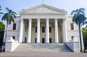
British Residency, Hyderabad
Ambassadorial residence in Hyderabad, India
Distance: Approx. 251 meters
Latitude and longitude: 17.3837248,78.4847522
Koti Residency or British Residency or "Hyderabad Residency" is an opulent mansion built by James Achilles Kirkpatrick in the princely state of Hyderabad. Kirkpatrick was British Resident of Hyderabad between 1798 and 1805. Today it is part of the Osmania University College for Women and has been converted into a museum.

Mahatma Gandhi Bus Station
Bus depot in India
Distance: Approx. 830 meters
Latitude and longitude: 17.378,78.484
The Mahatma Gandhi Bus Station (MGBS), also known as the Imlibun Bus Station (Imlibun means "grove of tamarind trees"), is a bus station on the Musi River in the Imlibun area of southern Hyderabad, India. It is owned by the Telangana State Road Transport Corporation (TGSRTC) and is India's fifth-largest bus station, covering 20 acres (81,000 m2), behind Chennai Mofussil Bus Terminus, Bengaluru's Kempegowda Bus Station, Vijayawada's Pandit Nehru Bus Station and Delhi's Millennium Park Bus Depot.
Insurance Regulatory and Development Authority
Regulatory body of the Government of India
Distance: Approx. 74 meters
Latitude and longitude: 17.385,78.486
The Insurance Regulatory and Development Authority of India (IRDAI) is an autonomous and statutory body under the jurisdiction of Ministry of Finance, Government of India. It is tasked with regulating and licensing the insurance and re-insurance industries in India. It was constituted by the Insurance Regulatory and Development Authority Act, 1999, an Act of Parliament passed by the Government of India.
Putlibowli
Neighbourhood in Hyderabad, Telangana, India
Distance: Approx. 646 meters
Latitude and longitude: 17.381399,78.481926
Putlibowli is one of the neighbourhoods in Hyderabad, India. It is part of the old city of Hyderabad.
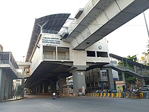
Osmania Medical College metro station
Metro station in Hyderabad, India
Distance: Approx. 872 meters
Latitude and longitude: 17.3823887,78.4789574
Osmania Medical College Metro Station is located on the Red Line of the Hyderabad Metro, India. This station was opened to public on 2018. It is near to Maharani Jhansi Road, Putli Bowli, Fruit Market, Jambagh Road, Osmania Medical College, Koti Bus stop and Vivek Vardhini College.
Weather in this IP's area
mist
26 Celsius
26 Celsius
26 Celsius
28 Celsius
1007 hPa
73 %
1007 hPa
952 hPa
6000 meters
7.2 m/s
320 degree
75 %
06:04:18
18:17:41