Country:
 Egypt
EgyptRegion:
City:
Latitude and Longitude:
Time Zone:
Postal Code:
IP information under different IP Channel
ip-api
Country
Region
City
ASN
Time Zone
ISP
Blacklist
Proxy
Latitude
Longitude
Postal
Route
IPinfo
Country
Region
City
ASN
Time Zone
ISP
Blacklist
Proxy
Latitude
Longitude
Postal
Route
MaxMind
Country
Region
City
ASN
Time Zone
ISP
Blacklist
Proxy
Latitude
Longitude
Postal
Route
Luminati
Country
EGASN
Time Zone
Africa/Cairo
ISP
TE Data
Latitude
Longitude
Postal
db-ip
Country
Region
City
ASN
Time Zone
ISP
Blacklist
Proxy
Latitude
Longitude
Postal
Route
ipdata
Country
Region
City
ASN
Time Zone
ISP
Blacklist
Proxy
Latitude
Longitude
Postal
Route
Popular places and events near this IP address

United Arab Republic
Sovereign state in the Middle East (1958–1971)
Distance: Approx. 869 meters
Latitude and longitude: 30.03333333,31.21666667
The United Arab Republic (UAR; Arabic: الجمهورية العربية المتحدة, romanized: al-Jumhūriyya al-ʿArabiyya al-Muttaḥida) was a sovereign state in the Middle East from 1958 until 1961. It was initially a political union between Egypt (including the governance of Gaza) and Syria from 1958 until Syria seceded from the union following the 1961 Syrian coup d'état. Egypt continued to be known officially as the United Arab Republic until it was formally dissolved by Anwar Sadat in September 1971.
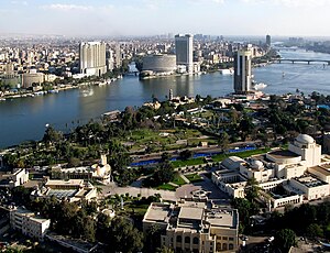
Cairo Governorate
Governorate in Egypt
Distance: Approx. 869 meters
Latitude and longitude: 30.03333333,31.21666667
Cairo Governorate (Arabic: محافظة القاهرة) is one of the 27 governorates of Egypt. It is formed of the city of Cairo, both the national capital of Egypt and the governorate's, in addition to five satellite cities: the New Administrative Capital - set to become the seat of national government, New Cairo, Shourok, Badr, Capital Gardens, and 15th of May. These cities form almost half of the Greater Cairo metropolitan area by population.

Dokki
District in Giza Governorate, Egypt
Distance: Approx. 132 meters
Latitude and longitude: 30.03805556,31.21111111
Dokki (Arabic: الدقي pronounced [ed.ˈdoʔ.ʔi], is one of nine districts that make up Giza city, which is part of Greater Cairo, in Egypt. Dokki is situated on the western bank of the Nile, directly across from Downtown Cairo. It is a vital residential and commercial district with major roads connecting the two parts of Greater Cairo (Cairo and Giza).
Ministry of Agriculture and Land Reclamation (Egypt)
Distance: Approx. 518 meters
Latitude and longitude: 30.04305556,31.20972222
The Ministry of Agriculture and Land Reclamation of Egypt is a ministerial body in charge of agriculture and land reclamation in Egypt.
Deutsche Evangelische Oberschule
Private school in Giza, Egypt
Distance: Approx. 681 meters
Latitude and longitude: 30.03234444,31.21079722
Deutsche Evangelische Oberschule (DEO; Arabic: المدرسة الألمانیة الإنجیلیة الثانویة بالقاهرة) is a German school in Dokki, Giza, Egypt, in the Cairo metropolitan area. It is operated by the German Protestant community of Cairo.
Egyptian e-Learning University
National university in Cairo, Egypt
Distance: Approx. 678 meters
Latitude and longitude: 30.0378,31.2168
National Egyptian E-Learning University (EELU) (Arabic: الجامعة المصرية للتعلم الإلكترونى الأهلية) is a non-profit Egyptian National University, and the first Egyptian university to offer E-Learning services. EELU was established through Decree No. 233 by the President of the Arab Republic of Egypt on August 16th, 2008 to provide distance education through 24-hour online learning.

Timeline of the Egyptian Crisis under the SCAF
Distance: Approx. 869 meters
Latitude and longitude: 30.03333333,31.21666667
The following is a chronological summary of the major events that occurred during the Egyptian Revolution of 2011, after Hosni Mubarak's resignation. Protests and riots led to the deaths of hundreds, injuries of thousands and the arrests of tens of thousands. Millions have mobilised the streets since the revolution.

Timeline of the Egyptian Crisis under Mohamed Morsi
Distance: Approx. 869 meters
Latitude and longitude: 30.03333333,31.21666667
The following is a chronological summary of the major events that occurred after the Egyptian Revolution of 2011, after Mohamed Morsi's election as the fifth President of Egypt, on 30 June 2012. This article documents the third wave of the Egyptian Crisis.

2012–2013 Egyptian protests
Period of unrest around the 2012 presidential elections and 2013 coup
Distance: Approx. 869 meters
Latitude and longitude: 30.03333333,31.21666667
The 2012–2013 Egyptian protests (sometimes called the Hirak Uprising) were part of the crisis in Egypt including the June 2013 protests, the July 2013 coup d'état, and part of the post-coup unrest. They saw varying opposition against three contiguous heads of state; namely, the Supreme Council of the Armed Forces (SCAF), Muslim Brotherhood, and the de facto ruling Egyptian Armed Forces. Beginning with the anniversary of the 2011 Egyptian revolution, small-scale protests took place in January demanding the military to step away from power.
Agricultural Museum, Egypt
Agricultural museum in Giza, Egypt
Distance: Approx. 924 meters
Latitude and longitude: 30.04666667,31.20888889
The Agricultural Museum is a museum in Cairo, Egypt.
Housing and Building National Research Center
Government housing agency in Egypt
Distance: Approx. 345 meters
Latitude and longitude: 30.036848,31.206705
Housing and Building National Research Center (HBRC) (in Arabic : المركز القومي لبحوث الإسكان والبناء ) is an Egyptian agency affiliated to Ministry of Housing
List of ambassadors of Iran to Egypt
Distance: Approx. 732 meters
Latitude and longitude: 30.039603,31.202332
The Iranian ambassador in Cairo was the official representative of the Government in Tehran to the Government of Egypt.
Weather in this IP's area
clear sky
22 Celsius
22 Celsius
22 Celsius
22 Celsius
1014 hPa
70 %
1014 hPa
1010 hPa
10000 meters
2.5 m/s
3.05 m/s
350 degree
06:58:58
18:21:13