Country:
Region:
City:
Latitude and Longitude:
Time Zone:
Postal Code:
IP information under different IP Channel
ip-api
Country
Region
City
ASN
Time Zone
ISP
Blacklist
Proxy
Latitude
Longitude
Postal
Route
Luminati
Country
ASN
Time Zone
Africa/Banjul
ISP
QCell
Latitude
Longitude
Postal
IPinfo
Country
Region
City
ASN
Time Zone
ISP
Blacklist
Proxy
Latitude
Longitude
Postal
Route
db-ip
Country
Region
City
ASN
Time Zone
ISP
Blacklist
Proxy
Latitude
Longitude
Postal
Route
ipdata
Country
Region
City
ASN
Time Zone
ISP
Blacklist
Proxy
Latitude
Longitude
Postal
Route
Popular places and events near this IP address

Serekunda
City in the Gambia
Distance: Approx. 818 meters
Latitude and longitude: 13.445,-16.675
Serekunda or Serrekunda is the largest urban centre in The Gambia. It is situated close to the Atlantic coast, on the Gambia River, near the capital, Banjul. Serekunda and Banjul form an urban area known as the Kombos, with about half of the population of the Gambia.

Kanifing
Municipality in the Gambia
Distance: Approx. 1190 meters
Latitude and longitude: 13.4475,-16.6725
Kanifing is a municipality, local government area and district in the Gambia. It is part of the Greater Banjul Area, to the west of Banjul. It is governed by the Kanifing Municipal Council.

Sukuta
Place in Western Division, The Gambia The Smiling cost of west Africa
Distance: Approx. 3380 meters
Latitude and longitude: 13.41666667,-16.7
Sukuta is a town located in the Western Division of the Gambia. It had a population of 16,667 as of the 1993 census.
Nema Kunku
Village in the Kanifing Local Government Area, Gambia
Distance: Approx. 3903 meters
Latitude and longitude: 13.40361111,-16.68333333
Nema Kunku is a village in the Brikama Local Government Area, Gambia. As of the 2013 census, Nema Kunku had a population of 36,134. Nema Kunku is located near Serekunda, with most of tourism to the area being sparked by Serekunda and the capital, Banjul.

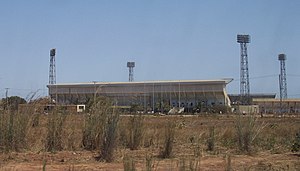
Independence Stadium (Bakau)
Distance: Approx. 3396 meters
Latitude and longitude: 13.46880556,-16.67780556
Independence Stadium is a multi-purpose stadium in Bakau, Gambia. It is currently used mostly for football matches, although it is also used for athletics, concerts, political events, trade fairs and national celebrations. The stadium holds 20,000 people.
The Daily Observer
Gambian newspaper
Distance: Approx. 4092 meters
Latitude and longitude: 13.475,-16.676
The Daily Observer is a newspaper published in Bakau in Banjul, the Gambia. The paper, Gambia's first daily newspaper, was founded by Mae Gene and Kenneth Best in 1990. Kenneth Best had previously managed another paper called the Daily Observer in Liberia, until the First Liberian Civil War caused him to relocate with his family to the Gambia.
Fajara
Place in Banjul, The Gambia
Distance: Approx. 4046 meters
Latitude and longitude: 13.47,-16.69638889
Fajara is a coastal suburb of Bakau in the Gambia. It is home to Isatou Njie-Saidy, a former Vice-President of the Gambia, the former US Ambassador, and formerly the home town of the late Sir Dawda Kairaba Jawara, a former Prime Minister of the Gambia and the first President of the Gambia. The Medical Research Council is located within a fenced complex on Atlantic Boulevard.
University of the Gambia
Public university based in Kanifing, The Gambia
Distance: Approx. 2256 meters
Latitude and longitude: 13.45722222,-16.68555556
The University of the Gambia (UTG) is an institution of higher education located in Sere Kunda, the largest city in the Gambia.
American International University West Africa
University in Serekunda, The Gambia
Distance: Approx. 2819 meters
Latitude and longitude: 13.46329,-16.673883
American International University West Africa established The Gambia campus in January 2011 in Serekunda. The University offers medical program leading to Doctor of Medicine (MD) Degree. The curriculum is based on American Medical Schools systems.
École Française de Banjul
Distance: Approx. 1063 meters
Latitude and longitude: 13.4478,-16.6791
École Française de Banjul is a French international school in Bakau, The Gambia, in the Banjul metropolitan area. It serves levels preschool through première; classes use the National Centre for Distance Education (CNED) beginning in sixième. It was established in 1984.
Latri Kunda
Distance: Approx. 1420 meters
Latitude and longitude: 13.45,-16.68333333
Latri Kunda (spelling variation: Latrikunda, name variant: Latri Kunda Yiringan Ya or Latrikunda Yiri Nganya) is part of the Kanifing District, and a suburb of Sere Kunda (or Serekunda) in The Gambia. The district is located in the center of Serekunda. In the 1993 census, Latri Kunda was listed as a separate town with 22,902 inhabitants.

Pipeline Mosque
Mosque in Serekunda, Gambia
Distance: Approx. 2286 meters
Latitude and longitude: 13.45773284,-16.68493762
The Pipeline Mosque is the main mosque of Serekunda, The Gambia.
Weather in this IP's area
clear sky
31 Celsius
32 Celsius
31 Celsius
31 Celsius
1010 hPa
45 %
1010 hPa
1008 hPa
10000 meters
2.57 m/s
350 degree
07:07:15
18:36:32

