41.221.180.152 - IP Lookup: Free IP Address Lookup, Postal Code Lookup, IP Location Lookup, IP ASN, Public IP
Country:
Region:
City:
Location:
Time Zone:
Postal Code:
IP information under different IP Channel
ip-api
Country
Region
City
ASN
Time Zone
ISP
Blacklist
Proxy
Latitude
Longitude
Postal
Route
Luminati
Country
Region
8
City
kidal
ASN
Time Zone
Africa/Bamako
ISP
IKATELNET
Latitude
Longitude
Postal
IPinfo
Country
Region
City
ASN
Time Zone
ISP
Blacklist
Proxy
Latitude
Longitude
Postal
Route
IP2Location
41.221.180.152Country
Region
kidal
City
kidal
Time Zone
Africa/Bamako
ISP
Language
User-Agent
Latitude
Longitude
Postal
db-ip
Country
Region
City
ASN
Time Zone
ISP
Blacklist
Proxy
Latitude
Longitude
Postal
Route
ipdata
Country
Region
City
ASN
Time Zone
ISP
Blacklist
Proxy
Latitude
Longitude
Postal
Route
Popular places and events near this IP address
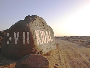
Kidal
Commune and town in Kidal Region, Mali
Distance: Approx. 253 meters
Latitude and longitude: 18.43888889,1.40833333
Kidal (Tuareg Berber: ⴾⴸⵍ, KDL, Kidal) is a town and commune in the desert region of northern Mali. The town lies 285 km (177 mi) northeast of Gao and is the capital of the Kidal Cercle and the Kidal Region. The commune has an area of about 9,910 km2 (3,830 sq mi) and includes the town of Kidal and 31 other settlements.
Kidal Airport
Airport in Mali
Distance: Approx. 1814 meters
Latitude and longitude: 18.43472222,1.42361111
Kidal Airport (ICAO: GAKL) (French: Aéroport de Kidal) is an airstrip serving Kidal in Mali.

Kidal Cercle
Cercle in Kidal Region, Mali
Distance: Approx. 6623 meters
Latitude and longitude: 18.5,1.41666667
Kidal Cercle is an administrative subdivision of the Kidal Region of Mali. The administrative center (chef-lieu) is the town of Kidal. The cercle is divided into rural and urban communes, and below this, quarters/villages.
April 2013 Kidal attack
Terrorist attack in Mali
Distance: Approx. 405 meters
Latitude and longitude: 18.4375,1.40833333
On 12 April 2013, four Chadian soldiers were killed, and five civilians were injured, in an attack by two suicide bombers affiliated with the MOJWA in Kidal, Mali.
Second Battle of Kidal
Distance: Approx. 63 meters
Latitude and longitude: 18.4411,1.4072
The Second Battle of Kidal took place during the Mali War, when MNLA forces in control of Kidal attacked Prime Minister Moussa Mara's convoy during a visit to the town. Consequently, Malian government forces launched an offensive to retake the city, successfully recapturing it. Since the foreign intervention in Mali, Kidal was retaken by French, Malian, and Chadian troops.
Weather in this IP's area
overcast clouds
18 Celsius
16 Celsius
18 Celsius
18 Celsius
1012 hPa
18 %
1012 hPa
958 hPa
10000 meters
2.49 m/s
2.55 m/s
49 degree
100 %
