Country:
Region:
City:
Latitude and Longitude:
Time Zone:
Postal Code:
IP information under different IP Channel
ip-api
Country
Region
City
ASN
Time Zone
ISP
Blacklist
Proxy
Latitude
Longitude
Postal
Route
Luminati
Country
ASN
Time Zone
Africa/Dakar
ISP
SUDATEL-SENEGAL
Latitude
Longitude
Postal
IPinfo
Country
Region
City
ASN
Time Zone
ISP
Blacklist
Proxy
Latitude
Longitude
Postal
Route
db-ip
Country
Region
City
ASN
Time Zone
ISP
Blacklist
Proxy
Latitude
Longitude
Postal
Route
ipdata
Country
Region
City
ASN
Time Zone
ISP
Blacklist
Proxy
Latitude
Longitude
Postal
Route
Popular places and events near this IP address

Dakar Region
Region of Senegal
Distance: Approx. 6386 meters
Latitude and longitude: 14.75,-17.33333333
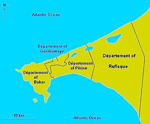
Dakar Region (French: Région de Dakar) is the smallest and most populated Region of Senegal, encompassing the capital city of the country, Dakar, and all its suburbs along the Cap–Vert Peninsula, Africa's most westerly point.

Pikine
City in Dakar Region, Senegal
Distance: Approx. 1909 meters
Latitude and longitude: 14.75,-17.4
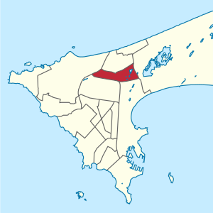
Pikine is a city in the Pikine Department of the Dakar Region of Senegal. Lying to the east of Dakar city centre, at the 2013 Census it had a population of 1,170,791. The department includes the villages of Yeumbeul, Thiaroye, Mbao, and Keur Massar Malika.

Guédiawaye
Town in Dakar Region, Senegal
Distance: Approx. 2313 meters
Latitude and longitude: 14.78333333,-17.4
Guédiawaye is a city in the Guédiawaye Department of the Dakar Region of Senegal. Lying on the Atlantic Ocean to the northeast of Dakar city centre, in 2013 it had a population of 329,659. Until the mid-2000s, the département was part of Pikine.

Guédiawaye Department
Department in Senegal
Distance: Approx. 1384 meters
Latitude and longitude: 14.77611111,-17.39555556
Guédiawaye Department is one of the 45 departments of Senegal and one of the four making up Dakar Region on the Cap-Vert peninsula.

Pikine Department
Department in Dakar Region, Senegal
Distance: Approx. 1867 meters
Latitude and longitude: 14.75027778,-17.39972222
Pikine Department is one of the 45 departments of Senegal and one of the four which make up Dakar Region. Its capital is Pikine. The department is divided into 2 arrondissements, each subdivided into communes de arrondissement: Dagoudane Arrondissement: Dalifort Djidah Thiaroye Kaw Guinaw Rail Nord Guinaw Rail Sud Pikine Est Pikine Nord Pikine Ouest Thiaroye Arrondissement Diamaguène Sicap Mbao Thiaroye-Gare Thiaroye-sur-Mer Thiaroye-Diaksao Thiaroye-Mbao Population In the census of 2023 the population of the department was recorded at 758,554.

Thiaroye
Town in Dakar Region, Senegal
Distance: Approx. 5596 meters
Latitude and longitude: 14.73333333,-17.35
Thiaroye (or Tiaroye) is the name of a historic town in Sénégal, situated in the suburbs of Dakar, on the southeast coast of the Cap-Vert peninsula, between Pikine and Rufisque. Since the administrative reform in 1996, Thiaroye has been divided into independent communes, Thiaroye-Gare, Thiaroye-sur-Mer and Thiaroye-Kao (or Djiddah Thiaroye Kao), with Guinaw-Rail Nord, Guinaw-Rail Sud (both to the west), and Tivaouane-Diacksao (to the east) split off and separating Thiaroye-sur-Mer from the other two inland communes.

Thiaroye massacre
Massacre of French West African troops by French forces
Distance: Approx. 1758 meters
Latitude and longitude: 14.756,-17.377
The Thiaroye massacre was a massacre of French West African soldiers, committed by the French Army on the morning of 1 December 1944 near Dakar, French Senegal. Those killed were members of the Tirailleurs Sénégalais, and were veterans of the 1940 Battle of France who had been recently liberated from prison camps in Europe. After being repatriated to West Africa, they mutinied against poor conditions and unpaid wages at the Thiaroye military camp.

Cambérène
Commune d'arrondissement in Dakar Region, Senegal
Distance: Approx. 4375 meters
Latitude and longitude: 14.77083333,-17.43083333
Cambérène is a commune d'arrondissement of the city of Dakar, Senegal. As of 2013 it had a population of 52,420.

Parcelles Assainies
Commune d'arrondissement in Dakar Region, Senegal
Distance: Approx. 4815 meters
Latitude and longitude: 14.75694444,-17.43472222
Parcelles Assainies is a commune d'arrondissement of the city of Dakar, Senegal. As of 2013 it had a population of 159,498.

Patte d'Oie (Dakar)
Commune d'arrondissement in Dakar Region, Senegal
Distance: Approx. 5163 meters
Latitude and longitude: 14.745,-17.43416667
Patte d'Oie is a commune d'arrondissement of the city of Dakar, Senegal.
Cap-Vert (volcano)
Upwellings of magma in western Senegal
Distance: Approx. 1168 meters
Latitude and longitude: 14.77,-17.4
Cap-Vert is a volcanic field in Senegal with a surface of 100 square kilometres (39 sq mi). The field covers the Cape Verde peninsula close to Dakar and was active until 600,000 years ago. It consists of a number of outcrops and two 100 metres (330 ft) high hills.
Hann Forest and Zoological Park
Zoo in Dakar, Senegal
Distance: Approx. 6352 meters
Latitude and longitude: 14.725542,-17.433716
The Hann Forest and Zoological Park (French: Parc forestier et zoologique de Hann) is a nature reserve located in Dakar, the capital of the African country of Senegal, in the Hann Bel-Air commune.
Weather in this IP's area
clear sky
28 Celsius
30 Celsius
28 Celsius
30 Celsius
1010 hPa
61 %
1010 hPa
1008 hPa
10000 meters
6.17 m/s
350 degree
07:12:02
18:37:27
