41.209.60.157 - IP Lookup: Free IP Address Lookup, Postal Code Lookup, IP Location Lookup, IP ASN, Public IP
Country:
Region:
City:
Location:
Time Zone:
Postal Code:
ISP:
ASN:
language:
User-Agent:
Proxy IP:
Blacklist:
IP information under different IP Channel
ip-api
Country
Region
City
ASN
Time Zone
ISP
Blacklist
Proxy
Latitude
Longitude
Postal
Route
db-ip
Country
Region
City
ASN
Time Zone
ISP
Blacklist
Proxy
Latitude
Longitude
Postal
Route
IPinfo
Country
Region
City
ASN
Time Zone
ISP
Blacklist
Proxy
Latitude
Longitude
Postal
Route
IP2Location
41.209.60.157Country
Region
kiambu
City
kikuyu
Time Zone
Africa/Nairobi
ISP
Language
User-Agent
Latitude
Longitude
Postal
ipdata
Country
Region
City
ASN
Time Zone
ISP
Blacklist
Proxy
Latitude
Longitude
Postal
Route
Popular places and events near this IP address

Alliance High School (Kenya)
Public national high school in Kenya
Distance: Approx. 1782 meters
Latitude and longitude: -1.26138889,36.66638889
The Alliance High School (AHS) is a public national high school for boys located in Kikuyu, Kenya. Established on 1 March 1926 by the Alliance of Protestant Churches (the Church of Scotland Mission (later known as the Presbyterian Church of East Africa or PCEA), Church of the Province of Kenya (CPK) (later known as the Anglican Church of Kenya), African Inland Church (AIC), the Friends Church (Quakers) and the Methodist Church) the school was later named the Alliance High School. It was one of the first schools in Kenya to offer secondary school education to Africans.
Kabete
Distance: Approx. 6392 meters
Latitude and longitude: -1.26666667,36.71666667
Kabete is the ancestral name of the present Kiambu county. Today, it is a neighbourhood that located along the border of Nairobi and Kiambu counties. It is located less than 15 km (9.3 mi) outside of the capital city of Nairobi.

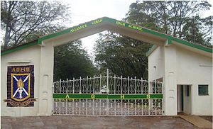
Alliance Girls High School
Public national boarding school in Kenya
Distance: Approx. 2294 meters
Latitude and longitude: -1.2663,36.6627
Alliance Girls' High School (AGHS) is a public national boarding school for girls located near the small town of Kikuyu in Kiambu County, 20 km from Nairobi. Founded in 1948 as the African Girls' High School, it is within walking distance from its brother school Alliance High School.
Gikambura
Place in Kiambu County, Kenya
Distance: Approx. 5313 meters
Latitude and longitude: -1.28,36.63
Gikambura is a settlement in Kenya's Kiambu County located in Kikuyu constituency.[1]
Lusigeti
Place in Kikuyu Constituency Kiambu, Kenya
Distance: Approx. 7536 meters
Latitude and longitude: -1.27,36.6
Lusigetti is a settlement in Kenya's Kikuyu Constituency Kiambu County.
Mararo
Place in Central Province, Kenya
Distance: Approx. 6559 meters
Latitude and longitude: -1.23,36.72
Mararo is a village settlement located in Kenya's former Central Province. The village is located in Githunguchu sub-Location, N'genda Location, Gatundu District, Gatundu South Constituency, Kiambu County. The village lies about 5 kilometres to the east of Gatundu Township.
Muguga
Settlement in Kiambu County, Kenya
Distance: Approx. 7460 meters
Latitude and longitude: -1.18,36.65
Muguga is a settlement in Kenya's Kiambu County, formerly in Central Province. It is the location of a Veterinary Research Centre.
Dagoretti High School
Provincial, public school in Nairobi, Kenya
Distance: Approx. 6523 meters
Latitude and longitude: -1.27554,36.713641
Dagoretti High School is a high school in the Dagoretti area of Nairobi county, Kenya. It is a Provincial School located 16 Kilometres from the Nairobi City centre along the Nairobi-Kikuyu Road. The School has eight streams (as from 2018) B, G, Y, P, W, C, M, R. It is a day and boarding school with a student population of roughly 1700.
Africa International University
Private university in Kenya
Distance: Approx. 6905 meters
Latitude and longitude: -1.301763,36.689759
Africa International University is a Christian university in Karen, Nairobi, Kenya.
Waithaka
A settlement in the Dagoretti area of Nairobi
Distance: Approx. 7130 meters
Latitude and longitude: -1.28222222,36.71583333
Waithaka is a settlement in Nairobi. Located within the Dagoretti area, it is approximately 11 km (7 mi) west of Nairobi central business district. It borders near Mutuini.
Nairobi Western Bypass Highway
Kenyan road
Distance: Approx. 1893 meters
Latitude and longitude: -1.23111111,36.67194444
Nairobi Western Bypass Highway is a road in Kenya. It connects the town of Kikuyu to the town of Ruaka, both in Kiambu County.
Mutuini
Place in Nairobi City, Kenya
Distance: Approx. 6067 meters
Latitude and longitude: -1.28805556,36.6975
Mutu-ini is a neighbourhood in Dagoretti in the city of Nairobi. It is approximately 13 kilometres (8.1 mi) west of the central business district of Nairobi.
Weather in this IP's area
overcast clouds
12 Celsius
11 Celsius
12 Celsius
12 Celsius
1016 hPa
80 %
1016 hPa
800 hPa
10000 meters
1.94 m/s
1.81 m/s
29 degree
100 %