41.191.219.205 - IP Lookup: Free IP Address Lookup, Postal Code Lookup, IP Location Lookup, IP ASN, Public IP
Country:
Region:
City:
Location:
Time Zone:
Postal Code:
ISP:
ASN:
language:
User-Agent:
Proxy IP:
Blacklist:
IP information under different IP Channel
ip-api
Country
Region
City
ASN
Time Zone
ISP
Blacklist
Proxy
Latitude
Longitude
Postal
Route
db-ip
Country
Region
City
ASN
Time Zone
ISP
Blacklist
Proxy
Latitude
Longitude
Postal
Route
IPinfo
Country
Region
City
ASN
Time Zone
ISP
Blacklist
Proxy
Latitude
Longitude
Postal
Route
IP2Location
41.191.219.205Country
Region
chobe
City
kasane
Time Zone
Africa/Gaborone
ISP
Language
User-Agent
Latitude
Longitude
Postal
ipdata
Country
Region
City
ASN
Time Zone
ISP
Blacklist
Proxy
Latitude
Longitude
Postal
Route
Popular places and events near this IP address

Kasane
Place in Chobe District, Botswana
Distance: Approx. 4 meters
Latitude and longitude: -17.81666667,25.15
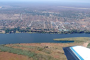
Kasane is a town in Botswana, close to Africa's 'Four Corners', where the borders of Botswana, Namibia, Zambia and Zimbabwe almost meet. The town is at the far northeastern corner of Botswana where it serves as the administrative center of the Chobe District. The population of Kasane was 9,244 at the 2011 census.

Sedudu
Island in Botswana
Distance: Approx. 1766 meters
Latitude and longitude: -17.81666667,25.13333333
Sedudu Island (known as Kasikili Island in Namibia) is a fluvial island in the Chobe River, in Botswana adjacent to the border with Namibia. The island was the subject of a territorial dispute between these countries, resolved by a 1999 ruling of the International Court of Justice (ICJ) that the border runs down the thalweg of the river immediately north (not south) of the island. The island is approximately 5 square kilometres (2 square miles) in area, with no permanent residents.

Kasane Airport
Airport in Chobe District, Botswana
Distance: Approx. 2246 meters
Latitude and longitude: -17.83194444,25.16388889
Kasane International Airport (IATA: BBK, ICAO: FBKE) is an airport serving Kasane, a town in the Chobe District of Botswana. The airport is located along the A33 road, 4 kilometres (2.5 mi) south of the town and 4 kilometres (2.5 mi) south of the border with Namibia. Air Botswana provides scheduled service between Kasane and Gaborone on Tuesdays, Fridays, and Sundays.

Impalila
Distance: Approx. 8615 meters
Latitude and longitude: -17.78333333,25.22333333
Impalila (sometimes spelt Mpalila) is an island in the Zambezi Region, the far eastern tip of Namibia, bounded on the north by the waters of the Zambezi river and on the south by the Chobe River. It is home to some 2500–3000 people in 25 small villages, including Tswanas (from Botswana) and Subia people (from Namibia). Impalila is usually accessed from Kasane in Botswana, on the other bank of the Chobe River.

Gibeon Constituency
Electoral constituency in the Hardap region of central Namibia
Distance: Approx. 5841 meters
Latitude and longitude: -17.7667,25.1333
Gibeon Constituency is an electoral constituency in the Hardap Region of Namibia. The administrative centre of the constituency is the village of Gibeon (Khoekhoe: Khaxa-tsûs). It had a population of 12,122 in 2011, up from 11,541 in 2001.
Punga, Namibia
Place in Namibia
Distance: Approx. 6472 meters
Latitude and longitude: -17.78333333,25.1
Punga is a village in Zambezi Region, Namibia.

Kazungula, Botswana
Place in Chobe District, Botswana
Distance: Approx. 9761 meters
Latitude and longitude: -17.80388889,25.24111111
Kazungula is a village in the far north of Botswana, 8 km east of the town of Kasane. It lies on the south bank of the Chobe and Zambezi rivers. Kazungula is the site of border crossings to the town in Zambia, also called Kazungula, across the Zambezi by the Kazungula Bridge (previously by the Kazungula Ferry), and to Zimbabwe at the Kazungula Road crossing.
Weather in this IP's area
moderate rain
28 Celsius
30 Celsius
28 Celsius
28 Celsius
1006 hPa
69 %
1006 hPa
900 hPa
4968 meters
3.17 m/s
4.5 m/s
33 degree
70 %