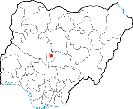
Country:
 Nigeria
Region:
City:
Latitude and Longitude:
Time Zone:
Postal Code:
IP information under different IP Channel
ip-api
Country
Region
City
ASN
Time Zone
ISP
Blacklist
Proxy
Latitude
Longitude
Postal
Route
IPinfo
Country
Region
City
ASN
Time Zone
ISP
Blacklist
Proxy
Latitude
Longitude
Postal
Route
MaxMind
Country
Region
City
ASN
Time Zone
ISP
Blacklist
Proxy
Latitude
Longitude
Postal
Route
Luminati
Country
NGRegion
fc
City
abuja
ASN
Time Zone
Africa/Lagos
ISP
IPNXng
Latitude
Longitude
Postal
db-ip
Country
Region
City
ASN
Time Zone
ISP
Blacklist
Proxy
Latitude
Longitude
Postal
Route
ipdata
Country
Region
City
ASN
Time Zone
ISP
Blacklist
Proxy
Latitude
Longitude
Postal
Route
Popular places and events near this IP address

Abuja
Capital of the Federal Republic of Nigeria
Distance: Approx. 1859 meters
Latitude and longitude: 9.06666667,7.48333333
Abuja () is the capital and sixth most populous city of Nigeria. Situated in the middle of the country within the Federal Capital Territory (FCT), it is a planned city built mainly in the 1980s based on a master plan by International Planning Associates (IPA), a consortium of three American planning and architecture firms made up of Wallace, Roberts, McHarg & Todd (WRMT – a group of architects) as the lead, Archi systems International (a subsidiary of the Howard Hughes Corporation), and Planning Research Corporation. The Central Business District of Abuja was designed by Japanese architect Kenzo Tange.

House of Representatives (Nigeria)
Lower house of the Nigerian National Assembly
Distance: Approx. 2010 meters
Latitude and longitude: 9.06805556,7.51111111
The House of Representatives (also called Green Chamber) is the lower chamber of Nigeria's bicameral National Assembly. The Senate is the upper chamber. The Green Chamber has 360 members who are elected in single-member constituencies using the plurality (or first-past-the-post) system, most recently in 2023.

National Christian Centre
Church in Nigeria
Distance: Approx. 594 meters
Latitude and longitude: 9.05194444,7.49444444
The National Christian Centre (previously known as the National Ecumenical Centre and sometimes known as the National Church of Nigeria) is a non-denominational Christian church building, located in Abuja, the capital of Nigeria.
Old Parade Ground
Sports stadium in Abuja, Nigeria
Distance: Approx. 1783 meters
Latitude and longitude: 9.04277778,7.48888889
Old Parade Ground is a stadium in the Garki District of Abuja, Nigeria. Built in the early 1980s, it is currently used mostly for football matches and is the home stadium of various teams in the Federal Capital Territory, including Abuja F.C. and Court of Appeal. The stadium has a capacity of about 5,000.
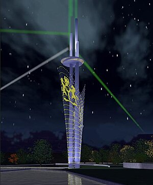
Millennium Tower (Abuja)
Mixed-Use in FCT, Nigeria
Distance: Approx. 460 meters
Latitude and longitude: 9.0558427,7.4928093
The Millennium Tower and Cultural Centre project is one of a number of projects in the Central District of Nigeria's capital city of Abuja. At 170 metres (560 ft), it is the tallest artificial structure in Abuja. The tower was designed by Manfredi Nicoletti and is part of the Nigeria National Complex which also includes the Nigerian Cultural Centre, an eight-storey, low rise, pyramid shaped Cultural Centre.
2011 Abuja United Nations bombing
Casualties of the 2011 Abuja United Nation's bombing
Distance: Approx. 820 meters
Latitude and longitude: 9.05,7.5
The 2011 Abuja bombing was a car bomb explosion on Friday, 26 August 2011 in the Nigerian capital Abuja's UN building that killed at least 21 and wounded 60. A spokesperson from the Sunni Islamist group Boko Haram later claimed responsibility. At about 11:00 WAT in the diplomatic zone in the centre of the city the car bomb vehicle broke through two security barriers.
Anglican Diocese of Abuja
Anglican diocese in Nigeria
Distance: Approx. 1859 meters
Latitude and longitude: 9.06666667,7.48333333
The Anglican Diocese of Abuja is one of 13 within the Anglican Province of Abuja, itself one of 14 provinces within the Church of Nigeria. As of March 2020, the bishop is Archbishop Henry Ndukuba, who is also Primate of the Church of Nigeria.

April 2014 Nyanya bombing
2014 bombing of a bus station in Nyanya, Nigeria by Boko Haram
Distance: Approx. 820 meters
Latitude and longitude: 9.05,7.5
On 14 April 2014 at about 6:45 am, two bombs exploded at a crowded bus station in Nyanya, Abuja, Nigeria, killing at least 88 people and injuring at least 200. The bus station is 8 km southwest of central Federal Capital Territory. Boko Haram claimed responsibility for the bombing six days later.
May 2014 Nyanya bombing
Distance: Approx. 820 meters
Latitude and longitude: 9.05,7.5
On 1 May 2014, a car bomb exploded in New Nyanya, a town in Nasarawa State, Nigeria. The explosion killed at least 19 people and injured at least 60.

June 2014 Kaduna and Abuja attacks
Distance: Approx. 1864 meters
Latitude and longitude: 9.0667,7.4833
Between 23 and 25 June 2014, a series of attacks occurred in central Nigeria. On 23–24 June, gunmen attacked a number of villages in Kaduna State, killing around 150 people. The attack was blamed on Fulani tribesmen.
Nigerian Export-Import Bank
Nigerian export credit agency
Distance: Approx. 713 meters
Latitude and longitude: 9.06222222,7.49361111
The Nigerian Export-Import Bank (NEXIM) is an export credit agency in Nigeria, established in 1991. In its function, NEXIM focuses on the development and expansion of the non-oil sectors of the Nigerian economy, with a view to reducing the country's over-reliance on oil exports.
Nigerian Defence Headquarters
Headquarters of the Nigerian Armed Forces
Distance: Approx. 1949 meters
Latitude and longitude: 9.040929,7.489195
The Nigerian Defence Headquarters (DHQ) is the principal headquarters of the Nigerian Armed Forces. It is situated in the Armed Forces Complex, which also houses the Nigerian Army, Air Force and, Nigerian Navy Headquarters. The DHQ is responsible for deployment, sustenance and recovery of forces deployed externally or within the country.
Weather in this IP's area
overcast clouds
27 Celsius
30 Celsius
27 Celsius
27 Celsius
1014 hPa
82 %
1014 hPa
960 hPa
10000 meters
0.73 m/s
1 m/s
223 degree
100 %
06:17:42
18:14:48