Country:
 USA
USARegion:
City:
Latitude and Longitude:
Time Zone:
Postal Code:
IP information under different IP Channel
ip-api
Country
Region
City
ASN
Time Zone
ISP
Blacklist
Proxy
Latitude
Longitude
Postal
Route
IPinfo
Country
Region
City
ASN
Time Zone
ISP
Blacklist
Proxy
Latitude
Longitude
Postal
Route
MaxMind
Country
Region
City
ASN
Time Zone
ISP
Blacklist
Proxy
Latitude
Longitude
Postal
Route
Luminati
Country
USRegion
md
City
chestertown
ASN
Time Zone
America/New_York
ISP
TALKIE-COMMUNICATIONS
Latitude
Longitude
Postal
db-ip
Country
Region
City
ASN
Time Zone
ISP
Blacklist
Proxy
Latitude
Longitude
Postal
Route
ipdata
Country
Region
City
ASN
Time Zone
ISP
Blacklist
Proxy
Latitude
Longitude
Postal
Route
Popular places and events near this IP address
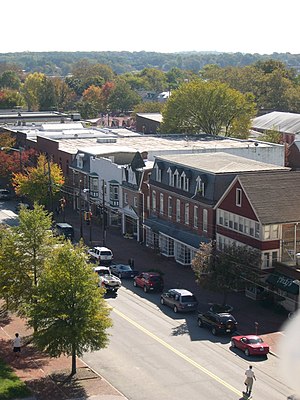
Chestertown, Maryland
Town in Maryland, United States
Distance: Approx. 1098 meters
Latitude and longitude: 39.21944444,-76.06833333
Chestertown is a town in Kent County, Maryland, United States. The population was 5,532 as of the 2020 census. It is the county seat of Kent County.
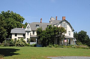
Washington College
Private liberal arts college in Chestertown, Maryland, US
Distance: Approx. 944 meters
Latitude and longitude: 39.21805556,-76.06944444
Washington College is a private liberal arts college in Chestertown, Maryland. Maryland granted Washington College its charter in 1782. George Washington supported the founding of the college by consenting to have the "College at Chester" named in his honor, through generous financial support, and through service on the college's Board of Visitors and Governors.
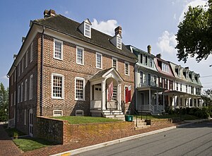
Chestertown Historic District (Chestertown, Maryland)
Historic district in Maryland, United States
Distance: Approx. 901 meters
Latitude and longitude: 39.2125,-76.06944444
Chestertown Historic District is a historic district in Chestertown, Maryland. It was listed on the National Register of Historic Places and designated a National Historic Landmark in 1970, and its area was increased in 1984. The town on the Chester River, became the chief port for tobacco and wheat on the Eastern Shore of Maryland between 1750 and 1790.

Widehall
Historic house in Maryland, United States
Distance: Approx. 1567 meters
Latitude and longitude: 39.2075,-76.06388889
Widehall is a historic and architecturally significant house in Chestertown, Kent County, Maryland. Built by Thomas Smyth III, 1769–1770, it is a contributing property in the Chestertown Historic District.
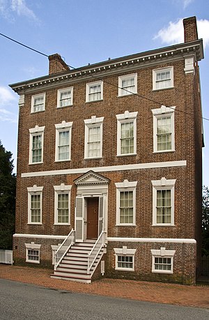
Denton House (Maryland)
Historic house in Maryland, United States
Distance: Approx. 1600 meters
Latitude and longitude: 39.20805556,-76.06305556
The Denton House, also known as the Denton-Weeks House, the River House, and the Smyth-Letherbury House, is a historic residence at 107 Water Street in Chestertown, Maryland. It is a three-story brick building, with a five-bay front facade framed by corner pilasters with stone capitals. The building has a raised basement, with a stone stringcourse between it and the first floor.

Brampton (Chestertown, Maryland)
Historic house in Maryland
Distance: Approx. 1418 meters
Latitude and longitude: 39.21194444,-76.09555556
Brampton is a historic home located at Chestertown, Kent County, Maryland. It is a transitional Greek Revival / Italianate-influenced dwelling built about 1860. The main section of the house is a three-story structure, constructed of brick with a symmetrical five-bay-wide facade and a depth of two bays.

Chestertown Armory
United States historic place
Distance: Approx. 1640 meters
Latitude and longitude: 39.20277778,-76.06833333
The Sergeant First Class John H. Newnam Armory, also known as the Chestertown Armory, is a former National Guard armory built in 1931 and located in Chestertown, Kent County, Maryland, United States. From 1932 until 2005 it housed various formations from the Maryland Army National Guard. It also was the home of sporting and community events.

Chestertown station
United States historic place
Distance: Approx. 1196 meters
Latitude and longitude: 39.20777778,-76.06888889
Chestertown is a historic railway station built in 1902–03 for the Pennsylvania Railroad and located in Chestertown, Kent County, Maryland. It is a 1+1⁄2-story, 17-by-47-foot (5.2 by 14.3 m) Queen Anne–style building. It features a hip roof with a wide bracketed overhang that provided shelter for train passengers on all four sides.
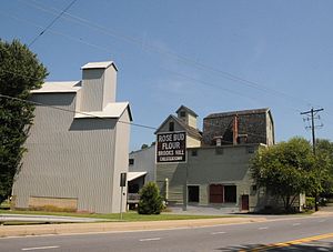
Radcliffe Mill
United States historic place
Distance: Approx. 502 meters
Latitude and longitude: 39.21916667,-76.08027778
The Radcliffe Mill is a historic grist mill and related structures located in Chestertown, Kent County, Maryland, United States. It consists of a Mill Building, built in 1891; Grain Elevator, probably constructed around 1924; and Annex / Seed House. The complex is historically significant for its association with the development of agriculture and the associated grist milling industry in Kent County.
Lauretum
Historic house in Maryland, United States
Distance: Approx. 743 meters
Latitude and longitude: 39.21944444,-76.08555556
Lauretum is a historic home located at Chestertown, Kent County, Maryland, United States. It is a large, three story late Victorian stuccoed frame house built in 1881 for Chestertown lawyer Harrison W. Vickers (1845-1911). Restored by Jennifer Corcoran and Family.

Charles Sumner Post No. 25, Grand Army of the Republic
United States historic place
Distance: Approx. 1509 meters
Latitude and longitude: 39.206875,-76.06520833
Charles Sumner Post #25, Grand Army of the Republic is a historic fraternal lodge building located in Chestertown, Kent County, Maryland. Named after Charles Sumner, it was constructed as a meeting hall about 1908 and is a two-story gable-front frame building, built on brick piers, with a rectangular floor plan. It is located in the Scotts Point area, a historically black area within the Chestertown Historic District, and was abandoned between 1985 and 2002.

Hynson–Ringgold House
Building in Chestertown, Maryland
Distance: Approx. 1544 meters
Latitude and longitude: 39.20677778,-76.06480556
The Hynson–Ringgold House, sometimes known as The Abbey, is the official residence of the president of Washington College. The building is in the Georgian style and is made entirely out of brick. In the rear of the building there is a large enclosed garden.
Weather in this IP's area
overcast clouds
24 Celsius
24 Celsius
23 Celsius
25 Celsius
1022 hPa
71 %
1022 hPa
1021 hPa
10000 meters
5.34 m/s
6.78 m/s
91 degree
100 %
06:46:59
19:11:13