Country:
 Canada
Region:
City:
Latitude and Longitude:
Time Zone:
Postal Code:
IP information under different IP Channel
ip-api
Country
Region
City
ASN
Time Zone
ISP
Blacklist
Proxy
Latitude
Longitude
Postal
Route
IPinfo
Country
Region
City
ASN
Time Zone
ISP
Blacklist
Proxy
Latitude
Longitude
Postal
Route
MaxMind
Country
Region
City
ASN
Time Zone
ISP
Blacklist
Proxy
Latitude
Longitude
Postal
Route
Luminati
Country
CARegion
mb
City
winnipeg
ASN
Time Zone
America/Winnipeg
ISP
OXIO-ASN-01
Latitude
Longitude
Postal
db-ip
Country
Region
City
ASN
Time Zone
ISP
Blacklist
Proxy
Latitude
Longitude
Postal
Route
ipdata
Country
Region
City
ASN
Time Zone
ISP
Blacklist
Proxy
Latitude
Longitude
Postal
Route
Popular places and events near this IP address
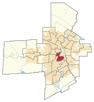
Fort Rouge (electoral district)
Provincial electoral district in Manitoba, Canada
Distance: Approx. 776 meters
Latitude and longitude: 49.873,-97.147
Fort Rouge (French: Fort-Rouge) is a provincial electoral division in the Canadian province of Manitoba. It was created by redistribution in 1957, and formally came into existence in the general election of 1958. The riding was eliminated in 1989, and re-established in 1999.
Lord Roberts (electoral district)
Defunct provincial electoral district in Manitoba, Canada
Distance: Approx. 959 meters
Latitude and longitude: 49.865,-97.145
Lord Roberts was a provincial electoral division in the Canadian province of Manitoba, located in the south-central section of the City of Winnipeg. It was created by redistribution in 1999, and consists primarily of territory taken from the now-defunct ridings of Osborne and Crescentwood. The district is named after Field Marshal Lord Roberts.
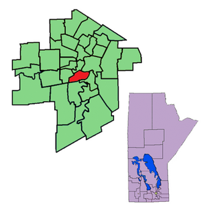
Winnipeg Metropolitan Region
Metropolitan area in Manitoba, Canada
Distance: Approx. 1042 meters
Latitude and longitude: 49.88,-97.13
The Winnipeg Metropolitan Region (formerly called the Winnipeg Capital Region and the Manitoba Capital Region) is a metropolitan area in the Canadian province of Manitoba located in the Red River Valley in the southeast portion of the province of Manitoba, Canada. It contains the provincial capital of Winnipeg and 17 surrounding rural municipalities, cities, and towns. Other places in the Region besides Winnipeg with a population over 1,000 are the city of Selkirk; towns of Stonewall and Niverville; and communities of Oakbank, Oak Bluff, Stony Mountain, Teulon, and Lorette.

CKY-FM
Radio station in Winnipeg, Canada
Distance: Approx. 766 meters
Latitude and longitude: 49.87675,-97.14347222
CKY-FM (102.3 MHz) is a commercial radio station in Winnipeg, Manitoba, branded as KiSS 102.3. The station airs a hot adult contemporary format, switching to Christmas music for most of December. It is owned by Rogers Radio, a division of Rogers Sports & Media, which also owns sister station 92.1 CITI-FM. The studios are in Osborne Village south of Downtown Winnipeg.

Fort Rouge, Winnipeg
Distance: Approx. 1120 meters
Latitude and longitude: 49.86666667,-97.15
Fort Rouge is a district of Winnipeg, Manitoba, in Canada. Located in the south-central part of the city, it is bounded on the north by the Assiniboine River, on the east and south by the Red River, and on the west by Stafford Street and Pembina Highway. It composes part of the city ward of Fort Rouge-East Fort Garry, as well as belonging to the provincial electoral district of Fort Rouge, and the federal electoral district of Winnipeg South Centre.
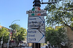
Nassau Street (Winnipeg)
Street in Manitoba
Distance: Approx. 758 meters
Latitude and longitude: 49.865,-97.139
Nassau Street is a 2-kilometre (1.2 mi) street in Winnipeg, Manitoba, located partially within the Osborne Village and Fort Rouge neighbourhoods. The north terminus of Nassau St. North is Roslyn Crescent and travels in a southeast direction, crossing Pembina Highway, swinging southwest before joining up with Garwood Avenue.
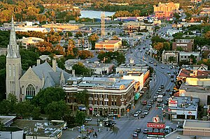
Osborne Village
Neighbourhood in Winnipeg, Manitoba, Canada
Distance: Approx. 1033 meters
Latitude and longitude: 49.87861111,-97.14583333
Osborne Village is a neighbourhood of Winnipeg, Manitoba. The area is bordered by the Assiniboine River on the north and west, Harkness Station on the east, and the Osborne Underpass on the south.
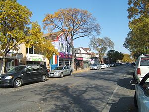
Little Italy, Winnipeg
Neighbourhood in Winnipeg, Manitoba, Canada
Distance: Approx. 1019 meters
Latitude and longitude: 49.8716,-97.1506
Little Italy, also known as Corydon Village, is a neighbourhood in Winnipeg, Manitoba, Canada. It is located on Corydon Avenue between Stafford Street on the west, and Pembina Highway on the east. The district has many boutiques and restaurants.
Nelson McIntyre Collegiate
Secondary school in Winnipeg, Manitoba, Canada
Distance: Approx. 1229 meters
Latitude and longitude: 49.8757,-97.1205
Nelson McIntyre Collegiate (NMC) is a grade 9-12 high school in Winnipeg, Manitoba. It is part of the Louis Riel School Division and has an enrollment of approximately 400 students. The school offers a wide range of programs for students of all skill levels and has a diverse student body that includes students from all over the world including International (Visa) Students from around the world.

Winnipeg Rowing Club
Sports club in Manitoba, Canada
Distance: Approx. 1108 meters
Latitude and longitude: 49.880951,-97.131089
Winnipeg Rowing Club (WRC) is a rowing club on the Red River in downtown Winnipeg, Manitoba. WRC provides adult and youth competitive rowing programs, and regularly sends crews to events like the Royal Canadian Henley Regatta, Western Canada Summer Games and Canada Games. WRC also offers recreational and independent rowing.
Churchill High School (Winnipeg)
Secondary school in Winnipeg, Manitoba, Canada
Distance: Approx. 595 meters
Latitude and longitude: 49.8672,-97.1317
Churchill High School is a secondary school in Winnipeg, Manitoba that teaches grades 7 to 12. It is part of the Winnipeg School Division.
Fort Rouge Curling Club
Distance: Approx. 1026 meters
Latitude and longitude: 49.8627,-97.1401
The Fort Rouge Curling Club is a curling club located in the Fort Rouge district of Winnipeg, Manitoba.
Weather in this IP's area
broken clouds
24 Celsius
24 Celsius
23 Celsius
24 Celsius
1001 hPa
80 %
1001 hPa
975 hPa
10000 meters
6.17 m/s
130 degree
75 %
07:09:49
19:35:18