Country:
 Canada
Region:
City:
Latitude and Longitude:
Time Zone:
Postal Code:
IP information under different IP Channel
ip-api
Country
Region
City
ASN
Time Zone
ISP
Blacklist
Proxy
Latitude
Longitude
Postal
Route
IPinfo
Country
Region
City
ASN
Time Zone
ISP
Blacklist
Proxy
Latitude
Longitude
Postal
Route
MaxMind
Country
Region
City
ASN
Time Zone
ISP
Blacklist
Proxy
Latitude
Longitude
Postal
Route
Luminati
Country
CARegion
on
City
thunderbay
ASN
Time Zone
America/Toronto
ISP
OXIO-ASN-01
Latitude
Longitude
Postal
db-ip
Country
Region
City
ASN
Time Zone
ISP
Blacklist
Proxy
Latitude
Longitude
Postal
Route
ipdata
Country
Region
City
ASN
Time Zone
ISP
Blacklist
Proxy
Latitude
Longitude
Postal
Route
Popular places and events near this IP address
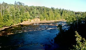
Current River (Ontario)
River in Ontario, Canada
Distance: Approx. 1695 meters
Latitude and longitude: 48.45222222,-89.18388889
The Current River is a river in the City of Thunder Bay and Unorganized Thunder Bay District in Thunder Bay District, Northwestern Ontario, Canada. The river is in the Great Lakes Basin and is a tributary of Lake Superior. The river's name comes from the French "Rivière aux courants", referring to the river's currents.
Port Arthur, Ontario
Former city in Ontario, Canada
Distance: Approx. 2425 meters
Latitude and longitude: 48.45,-89.23
Port Arthur was a city in Northern Ontario, Canada, located on Lake Superior. In January 1970, it amalgamated with Fort William and the townships of Neebing and McIntyre to form the city of Thunder Bay. Port Arthur had been the district seat of Thunder Bay District.

Centennial Park (Thunder Bay)
Municipal park in Thunder Bay, Ontario
Distance: Approx. 1852 meters
Latitude and longitude: 48.47722222,-89.19388889
Developed in 1967, Centennial Park is a large park area that follows the shores of the rocky Current River in the north end of Thunder Bay, Ontario. The park was built to represent the history of logging in Port Arthur (Now part of Thunder Bay). The park features many replicas of the equipment and living conditions on logging camps in the early 20th century.
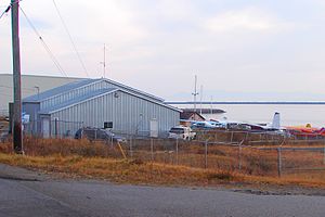
Thunder Bay Water Aerodrome
Airport in Thunder Bay, Ontario
Distance: Approx. 2912 meters
Latitude and longitude: 48.45,-89.16666667
Thunder Bay Water Aerodrome (TC LID: CKE6) is located on Shipyard Road adjacent to Thunder Bay, Ontario, Canada. The airport is classified as an airport of entry by Nav Canada and is staffed by the Canada Border Services Agency (CBSA). CBSA officers at this airport can handle general aviation aircraft only, with no more than 15 passengers.
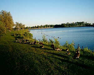
Current River Greenway
Public greenspace in Thunder Bay, Ontario
Distance: Approx. 649 meters
Latitude and longitude: 48.45833333,-89.19472222
The Current River Greenway is a 263 hectare (650 acre) greenway located in Current River neighbourhood in the north end of Thunder Bay, Ontario along the Current River. Throughout the Greenway is 50 km of public trails that are part of the Thunder Bay Recreational Trails and the Trans Canada Trail system. Five kilometres of paved trail circle Boulevard Lake.
Conseil scolaire de district catholique des Aurores boréales
Distance: Approx. 2756 meters
Latitude and longitude: 48.44388889,-89.22833333
The Conseil scolaire de district catholique des Aurores boréales oversees 10 French language Catholic schools in Thunder Bay District, Ontario, Canada. It administers education at nine elementary schools, and one secondary school.
St. Ignatius High School (Thunder Bay)
High school in Thunder Bay, Ontario, Canada
Distance: Approx. 1043 meters
Latitude and longitude: 48.45277778,-89.19694444
St. Ignatius High School is a Catholic high school located in the north end of Thunder Bay, Ontario. It is part of the Thunder Bay Catholic District School Board, and its amenities include a chapel, comprehensive science labs, computer labs, custom-designed music room, electronic media studios, fully equipped library, nutrition studies lab, physical education facilities, student resource areas, technology rooms (automotive, manufacturing, construction, drafting), and a theatre arts rooms with an auditorium.

Current River, Thunder Bay, Ontario
Neighbourhood in Thunder Bay, Ontario
Distance: Approx. 1500 meters
Latitude and longitude: 48.46666667,-89.18333333
Current River is a neighbourhood located north east of Port Arthur in the city of Thunder Bay, Ontario. It is separated from the main urban area of Thunder Bay by the Current River Greenway, a large parkland along the river after which the neighbourhood was named. It is home to approximately 4,780 people and has an ageing and declining population.
Western Dry Dock and Shipbuilding Company
Shipyard on Lake Superior
Distance: Approx. 1937 meters
Latitude and longitude: 48.45305556,-89.17916667
The Western Dry Dock and Shipbuilding Company was a shipyard that operated at Port Arthur, Ontario, now part of Thunder Bay, on Lake Superior from 1911 to 1993. The shipyard was established in 1909 and renamed in 1916 as the Port Arthur Shipbuilding Company. The yard closed in 1993.
Superior Collegiate and Vocational Institute
High school in Thunder Bay, Ontario, Canada
Distance: Approx. 2306 meters
Latitude and longitude: 48.44944444,-89.2275
Superior Collegiate and Vocational Institute (SCVI) is a high school in Thunder Bay, Ontario and is part of the Lakehead District School Board system. The school opened in September, 2009. It has approximately 600 students.

Superior Court of Justice Building (Thunder Bay)
Historic building in Thunder Bay, Ontario
Distance: Approx. 2989 meters
Latitude and longitude: 48.4379,-89.2214
Superior Court of Justice Building, Thunder Bay is a former courthouse built in 1924 by Chief Architect for Ontario Francis R. Heakes. The simple Beaux-Arts building served as a courthouse from 1924 to 2014. The Superior Court of Justice (277 Camelot Street) and Ontario Court of Justice (1805 Arthur Street East) had operated in separate buildings but relocated to the new Thunder Bay Courthouse (125 Brodie Street North) in 2014.
HMCS Griffon
Military unit
Distance: Approx. 2725 meters
Latitude and longitude: 48.44006,-89.21991
HMCS Griffon is a Royal Canadian Naval Reserve Division (NRD) located in Thunder Bay, Ontario. Dubbed a stone frigate, HMCS Griffon is a land-based naval establishment for part-time sailors as well as a local recruitment centre for the Royal Canadian Naval Reserve. It is one of Royal Canadian Naval Reserve divisions 24 naval reserve divisions located in major cities across Canada.
Weather in this IP's area
few clouds
18 Celsius
18 Celsius
18 Celsius
19 Celsius
1012 hPa
77 %
1012 hPa
987 hPa
10000 meters
2.06 m/s
60 degree
20 %
07:38:34
20:03:06