Country:
 Canada
Region:
City:
Latitude and Longitude:
Time Zone:
Postal Code:
IP information under different IP Channel
ip-api
Country
Region
City
ASN
Time Zone
ISP
Blacklist
Proxy
Latitude
Longitude
Postal
Route
IPinfo
Country
Region
City
ASN
Time Zone
ISP
Blacklist
Proxy
Latitude
Longitude
Postal
Route
MaxMind
Country
Region
City
ASN
Time Zone
ISP
Blacklist
Proxy
Latitude
Longitude
Postal
Route
Luminati
Country
CARegion
mb
City
winnipeg
ASN
Time Zone
America/Winnipeg
ISP
OXIO-ASN-01
Latitude
Longitude
Postal
db-ip
Country
Region
City
ASN
Time Zone
ISP
Blacklist
Proxy
Latitude
Longitude
Postal
Route
ipdata
Country
Region
City
ASN
Time Zone
ISP
Blacklist
Proxy
Latitude
Longitude
Postal
Route
Popular places and events near this IP address

Winnipeg South Centre
Federal electoral district in Manitoba, Canada
Distance: Approx. 362 meters
Latitude and longitude: 49.862,-97.165
Winnipeg South Centre (French: Winnipeg-Centre-Sud) is a federal electoral district in Manitoba, Canada, that has been represented in the House of Commons of Canada from 1925 to 1979 and since 1988.
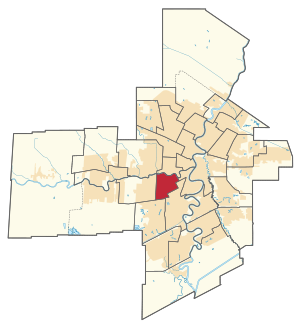
River Heights (electoral district)
Provincial electoral district in Manitoba, Canada
Distance: Approx. 664 meters
Latitude and longitude: 49.859,-97.175
River Heights is a provincial electoral division in the Canadian province of Manitoba. It was created by redistribution in 1957, and formally came into existence in the 1958 provincial election. The riding is located in the south-central region of the City of Winnipeg.
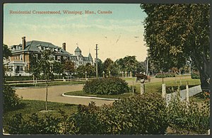
Crescentwood, Winnipeg
Neighbourhood
Distance: Approx. 626 meters
Latitude and longitude: 49.86722222,-97.1625
Crescentwood is a neighbourhood in the River Heights area of Winnipeg, Manitoba, Canada. It is bordered on the north by Academy Road, on the east by the Assiniboine River, on the south by Corydon Avenue, and on the west by Cambridge Street.
St. Mary's Academy (Winnipeg)
Private girls-only school in Winnipeg, Manitoba, Canada
Distance: Approx. 1365 meters
Latitude and longitude: 49.87555556,-97.16444444
St. Mary's Academy is a private Catholic girls' school in Winnipeg, Manitoba, Canada. It was founded by the Grey Nuns in 1869, with the Sisters of the Holy Names of Jesus and Mary assuming responsibility for the school in 1874.

Kelvin High School
High school in Winnipeg, Manitoba
Distance: Approx. 1049 meters
Latitude and longitude: 49.87305556,-97.1675
Kelvin High School is a public high school in Winnipeg, Manitoba, Canada. The school is located in the neighbourhood of River Heights. Kelvin teaches grades 9 to 12 and is part of the South District of the Winnipeg School Division.
St. Ignatius School
Catholic school in Winnipeg, Canada
Distance: Approx. 599 meters
Latitude and longitude: 49.867,-97.1627
St. Ignatius School is a Roman Catholic school in Winnipeg, Manitoba. It was opened on January 12, 1911, by the Parish of St.
Grant Park, Winnipeg
Neighborhood in Winnipeg, Manitoba, Canada
Distance: Approx. 993 meters
Latitude and longitude: 49.85583333,-97.16277778
Grant Park is a neighbourhood in the River Heights area of southern Winnipeg, Manitoba.
Grant Park Shopping Centre
Shopping center in Winnipeg, Manitoba
Distance: Approx. 708 meters
Latitude and longitude: 49.8578,-97.1656
Grant Park Shopping Centre (formerly Grant Park Plaza) is a 70-shop, nearly 400,000-square-foot shopping centre in the Grant Park area of southwest Winnipeg, Manitoba, Canada. Located near the mall are Grant Park High School and the Pan-Am Pool.

Pan Am Pool
Swimming facility in Winnipeg, Manitoba
Distance: Approx. 986 meters
Latitude and longitude: 49.85519444,-97.17313333
The Pan Am Pool is an indoor swimming facility in Winnipeg, Manitoba, Canada built for the 1967 Pan American Games. It is located in southwest Winnipeg and consists of three pools: two are used for competitive swimming and one is a children's "kiddie pool".
Grant Park High School
Public high school in Winnipeg, Manitoba, Canada
Distance: Approx. 850 meters
Latitude and longitude: 49.8561,-97.1705
Grant Park High School is a high school located in Winnipeg, Manitoba, Canada, that was founded in 1959. It is part of the Winnipeg School Division and teaches grades 7 to 12.
Rockwood, Winnipeg
Neighbourhood in Winnipeg, Canada
Distance: Approx. 282 meters
Latitude and longitude: 49.8616,-97.1671
Rockwood is a neighbourhood in the River Heights area of south-central Winnipeg, Manitoba. Its borders are Corydon Avenue on the north, Stafford Street on the east, Grant Avenue to the south, and Cambridge Street to the west. Adjacent neighbourhoods are Crescentwood to the north, Grant Park to the south, Central River Heights to the West, and Earl Grey (Fort Rouge) to the east.
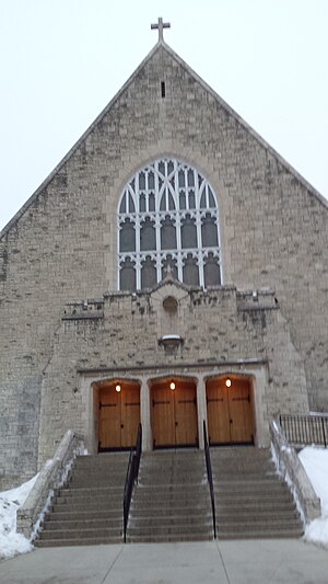
St. Ignatius Church (Winnipeg)
Church in Manitoba, Canada
Distance: Approx. 717 meters
Latitude and longitude: 49.867477,-97.161212
St Ignatius Church is a Roman Catholic Parish church in Winnipeg, Manitoba. It was founded in 1908 by the Society of Jesus and went on to found St. Ignatius School.
Weather in this IP's area
broken clouds
24 Celsius
24 Celsius
23 Celsius
24 Celsius
1001 hPa
80 %
1001 hPa
975 hPa
10000 meters
6.17 m/s
130 degree
75 %
07:09:57
19:35:26