Country:
 Canada
Region:
City:
Latitude and Longitude:
Time Zone:
Postal Code:
IP information under different IP Channel
ip-api
Country
Region
City
ASN
Time Zone
ISP
Blacklist
Proxy
Latitude
Longitude
Postal
Route
IPinfo
Country
Region
City
ASN
Time Zone
ISP
Blacklist
Proxy
Latitude
Longitude
Postal
Route
MaxMind
Country
Region
City
ASN
Time Zone
ISP
Blacklist
Proxy
Latitude
Longitude
Postal
Route
Luminati
Country
CARegion
mb
City
winnipeg
ASN
Time Zone
America/Winnipeg
ISP
OXIO-ASN-01
Latitude
Longitude
Postal
db-ip
Country
Region
City
ASN
Time Zone
ISP
Blacklist
Proxy
Latitude
Longitude
Postal
Route
ipdata
Country
Region
City
ASN
Time Zone
ISP
Blacklist
Proxy
Latitude
Longitude
Postal
Route
Popular places and events near this IP address

Assiniboine River
River in Western Canada
Distance: Approx. 204 meters
Latitude and longitude: 49.88583333,-97.12888889
The Assiniboine River ( ə-SIN-ih-boyn; French: Rivière Assiniboine) is a 1,070-kilometre (660 mi) river that runs through the prairies of Western Canada in Saskatchewan and Manitoba. It is a tributary of the Red River. The Assiniboine is a typical meandering river with a single main channel embanked within a flat, shallow valley in some places and a steep valley in others.
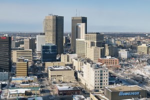
Winnipeg Metropolitan Region
Metropolitan area in Manitoba, Canada
Distance: Approx. 454 meters
Latitude and longitude: 49.88,-97.13
The Winnipeg Metropolitan Region (formerly called the Winnipeg Capital Region and the Manitoba Capital Region) is a metropolitan area in the Canadian province of Manitoba located in the Red River Valley in the southeast portion of the province of Manitoba, Canada. It contains the provincial capital of Winnipeg and 17 surrounding rural municipalities, cities, and towns. Other places in the Region besides Winnipeg with a population over 1,000 are the city of Selkirk; towns of Stonewall and Niverville; and communities of Oakbank, Oak Bluff, Stony Mountain, Teulon, and Lorette.

Fort Gibraltar
Historic trading outpost in present-day Manitoba, Canada
Distance: Approx. 348 meters
Latitude and longitude: 49.8871,-97.1294
Fort Gibraltar was founded in 1809 by Alexander Macdonell of Greenfield of the North West Company in present-day Manitoba, Canada. It was located at the confluence of the Red and Assiniboine rivers in or near the area now known as The Forks in the city of Winnipeg. Fort Gibraltar was renamed Fort Garry after the merger of North West Company and the Hudson's Bay Company in 1821, and became Upper Fort Garry in 1835.

The Forks, Winnipeg
Historic Meeting Place in Manitoba, Canada
Distance: Approx. 351 meters
Latitude and longitude: 49.88694444,-97.13055556
The Forks (French: La Fourche) is a historic site, meeting place, and green space in downtown Winnipeg located at the confluence of the Red River and the Assiniboine River. The Forks was designated a National Historic Site of Canada in 1974 due to its status as a cultural landscape that had borne witness to six thousand years of human activity. The site's 5.5-hectare (14-acre; 0.021 sq mi) grounds are open year-round.
Fort Rouge (fortification)
1738–1749 Canadian trading fort
Distance: Approx. 472 meters
Latitude and longitude: 49.888,-97.131
Fort Rouge was a fort located on the Assiniboine River in Manitoba, Canada, on the site of what is now the city of Winnipeg. Its exact location is unknown. Its name in English means "red fort".
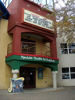
Manitoba Theatre for Young People
Distance: Approx. 554 meters
Latitude and longitude: 49.88813889,-97.13307778
Manitoba Theatre for Young People (MTYP) is a theatre for children and young adults in The Forks area of Winnipeg, Manitoba, Canada. As of 2012, MTYP's annual attendance regularly exceeds 100,000. Within the theatre complex are two performance venues: a 315-seat Main Stage and a smaller hall.

Le Musée de Saint-Boniface Museum
Civic museum in Manitoba, Canada
Distance: Approx. 589 meters
Latitude and longitude: 49.88777778,-97.12305556
Le Musée de Saint-Boniface Museum (also known as the St. Boniface Museum) is a museum in Winnipeg, Manitoba, Canada, that is dedicated to Franco-Manitoban and Métis culture and history. It is located in the oldest building in Winnipeg, a former convent of the Grey Nuns.
Manitoba Children's Museum
Children's museum in Winnipeg, Manitoba
Distance: Approx. 402 meters
Latitude and longitude: 49.887609,-97.12847
The Manitoba Children's Museum is a non-profit, charitable children's museum located at The Forks in Winnipeg, Manitoba, Canada.

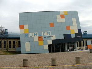
Winnipeg Railway Museum
Railway museum in Manitoba, Canada
Distance: Approx. 602 meters
Latitude and longitude: 49.888515,-97.133424
The Winnipeg Railway Museum was a railway museum located on tracks 1 and 2 within the Via Rail-operated Union Station in Winnipeg, Manitoba, Canada. Volunteers from the Midwestern Rail Association Inc., a non-profit organization founded in 1975, operated the museum. The museum was affiliated with CMA, CHIN and Virtual Museum of Canada.

Winnipeg Rowing Club
Sports club in Manitoba, Canada
Distance: Approx. 377 meters
Latitude and longitude: 49.880951,-97.131089
Winnipeg Rowing Club (WRC) is a rowing club on the Red River in downtown Winnipeg, Manitoba. WRC provides adult and youth competitive rowing programs, and regularly sends crews to events like the Royal Canadian Henley Regatta, Western Canada Summer Games and Canada Games. WRC also offers recreational and independent rowing.

St. Boniface Hospital
Hospital in Manitoba , Canada
Distance: Approx. 277 meters
Latitude and longitude: 49.88444444,-97.125
Saint Boniface Hospital (French: Hôpital Saint-Boniface; also called St. B; previously called the Saint-Boniface General Hospital) is Manitoba's second-largest hospital, located in the St. Boniface neighbourhood of Winnipeg.
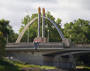
Norwood Bridge
Bridge in Manitoba, Canada
Distance: Approx. 163 meters
Latitude and longitude: 49.88280556,-97.13011111
The Norwood Bridge is a five-span, 167-metre (548 ft) vehicular bridge over the Red River in Winnipeg, Manitoba. The bridge links downtown Winnipeg with the Norwood neighbourhood of St. Boniface, Winnipeg, and serves Route 52.
Weather in this IP's area
broken clouds
24 Celsius
24 Celsius
23 Celsius
24 Celsius
1001 hPa
80 %
1001 hPa
975 hPa
10000 meters
6.17 m/s
130 degree
75 %
07:09:47
19:35:17