Country:
 Canada
Region:
City:
Latitude and Longitude:
Time Zone:
Postal Code:
IP information under different IP Channel
ip-api
Country
Region
City
ASN
Time Zone
ISP
Blacklist
Proxy
Latitude
Longitude
Postal
Route
IPinfo
Country
Region
City
ASN
Time Zone
ISP
Blacklist
Proxy
Latitude
Longitude
Postal
Route
MaxMind
Country
Region
City
ASN
Time Zone
ISP
Blacklist
Proxy
Latitude
Longitude
Postal
Route
Luminati
Country
CARegion
mb
City
winnipeg
ASN
Time Zone
America/Winnipeg
ISP
OXIO-ASN-01
Latitude
Longitude
Postal
db-ip
Country
Region
City
ASN
Time Zone
ISP
Blacklist
Proxy
Latitude
Longitude
Postal
Route
ipdata
Country
Region
City
ASN
Time Zone
ISP
Blacklist
Proxy
Latitude
Longitude
Postal
Route
Popular places and events near this IP address
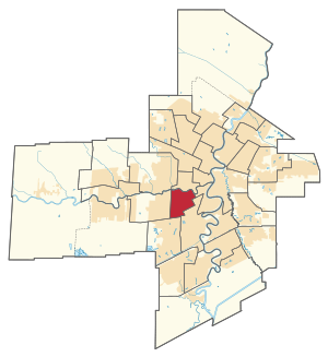
River Heights (electoral district)
Provincial electoral district in Manitoba, Canada
Distance: Approx. 1709 meters
Latitude and longitude: 49.859,-97.175
River Heights is a provincial electoral division in the Canadian province of Manitoba. It was created by redistribution in 1957, and formally came into existence in the 1958 provincial election. The riding is located in the south-central region of the City of Winnipeg.
Omand's Creek
Distance: Approx. 1382 meters
Latitude and longitude: 49.87861111,-97.19083333
Omand's Creek is a stream that runs throughout Winnipeg, Manitoba, Canada. Its surroundings vary, from prairie to box stores. It additionally runs through Omand Park and Bluestem Nature Park in the Wolseley area, into the Assiniboine River.
Tuxedo, Winnipeg
Suburb of Winnipeg, Canada
Distance: Approx. 1953 meters
Latitude and longitude: 49.86194444,-97.22194444
Tuxedo is a residential suburb of Winnipeg, Manitoba. It is located about 7 kilometres (4.5 miles) southwest of downtown Winnipeg, and borders the Assiniboine River and Assiniboine Park on the north, Shaftesbury Boulevard on the west, Route 90 to the East and McGillvary Boulevard to the South. Prior to 1972, the community was incorporated as the Town of Tuxedo.
River Heights, Winnipeg
Neighbourhood in south Winnipeg, Manitoba
Distance: Approx. 559 meters
Latitude and longitude: 49.86416667,-97.18888889
River Heights is a suburb and community area in Winnipeg, Manitoba. It is bordered by Route 90 to the west, the Assiniboine River to the north, Cambridge Street to the east, and Taylor Avenue to the south.

Polo Park
Regional shopping centre in Manitoba, Canada
Distance: Approx. 1929 meters
Latitude and longitude: 49.8838,-97.199
Polo Park (corporately styled as CF Polo Park) is a shopping centre in Winnipeg, Manitoba, Canada. It is situated on the former Polo Park Racetrack near the junction of Portage Avenue and St. James Street.
Polo Park Racetrack
Former horse racing venue in Manitoba
Distance: Approx. 1945 meters
Latitude and longitude: 49.8839,-97.1995
The Polo Park Racetrack was a Canadian horse racing facility in Winnipeg, Manitoba. Considered one of the finest racetracks in Western Canada, it was built by Canadian Horse Racing Hall of Fame inductee R. James Speers. The six-furlong track opened in 1925 (replacing Speer's River Park Racetrack) under the charter of the Winnipeg Jockey Club and the charter of St.
Jewish Heritage Centre (Winnipeg)
Distance: Approx. 1086 meters
Latitude and longitude: 49.8719,-97.2084
The Jewish Heritage Centre hosts the Marion and Ed Vickar Jewish Museum of Western Canada in Winnipeg, Manitoba, Canada. The museum opened in 1998 and displays the Jewish history of settlement in Western Canada. Located on the Asper Jewish Community Campus, the centre is involved in preserving, documenting, interpreting and sharing Jewish heritage.
Ohr HaTorah Day School
Jewish day school in Winnipeg, Manitoba, Canada
Distance: Approx. 973 meters
Latitude and longitude: 49.859,-97.189
Ohr HaTorah Day School was an Orthodox Jewish day school, located in the River Heights neighbourhood of Winnipeg, Manitoba, Canada. It existed between 1998 - 2011, when it closed due to declining enrollment. The school was founded in 1998 by a group of parents who were interested in a combination of high-level studies in both Torah and general subjects.

Wellington Crescent
Neighbourhood in Winnipeg, Manitoba, Canada
Distance: Approx. 1545 meters
Latitude and longitude: 49.8765,-97.1806
Wellington Crescent is an affluent neighbourhood in Winnipeg, Manitoba, Canada. It is known for its stately homes and for a small commercial area along Academy Road. It is in the northern section of the River Heights community area, along the Assiniboine River, which marks the neighbourhood's northern boundary.
Gray Academy of Jewish Education
School
Distance: Approx. 1170 meters
Latitude and longitude: 49.8723,-97.2094
The Gray Academy of Jewish Education is a pluralistic Jewish day school in Winnipeg, Manitoba, and the only K–12 Jewish day school in western Canada. The trustee and policy-making body of the school is the Winnipeg Board of Jewish Education, which is a member of the Canadian Accredited Independent Schools and the Manitoba Federation of Independent Schools.
Naawi-Oodena
Reserve in Canada
Distance: Approx. 1711 meters
Latitude and longitude: 49.85416667,-97.20972222
Naawi-Oodena (Anishinaabemowin; English: "centre of the heart and community") is an urban reserve in Manitoba. Jointly controlled by the Brokenhead, Long Plain, Peguis, Roseau River, Sagkeeng, Sandy Bay and Swan Lake First Nations, the 64-acre parcel is located near the River Heights and Tuxedo neighbourhoods of southwest Winnipeg, and is the largest urban reserve in Canada. The land was formerly occupied by the Kapyong Barracks of Princess Patricia's Canadian Light Infantry.
Ecole Tuxedo Park School
School in Winnipeg, Manitoba, Canada
Distance: Approx. 1525 meters
Latitude and longitude: 49.86611111,-97.21694444
École Tuxedo Park School is a French immersion elementary school in Winnipeg, Manitoba, Canada. It teaches grades K-4 and is part of the Pembina Trails School Division.
Weather in this IP's area
broken clouds
24 Celsius
24 Celsius
23 Celsius
24 Celsius
1001 hPa
80 %
1001 hPa
975 hPa
10000 meters
6.17 m/s
130 degree
75 %
07:10:03
19:35:33