Country:
Region:
City:
Latitude and Longitude:
Time Zone:
Postal Code:
IP information under different IP Channel
ip-api
Country
Region
City
ASN
Time Zone
ISP
Blacklist
Proxy
Latitude
Longitude
Postal
Route
Luminati
Country
Region
cus
City
cusco
ASN
Time Zone
America/Lima
ISP
TELCOM MIKROTIK PERU S.A.C.
Latitude
Longitude
Postal
IPinfo
Country
Region
City
ASN
Time Zone
ISP
Blacklist
Proxy
Latitude
Longitude
Postal
Route
db-ip
Country
Region
City
ASN
Time Zone
ISP
Blacklist
Proxy
Latitude
Longitude
Postal
Route
ipdata
Country
Region
City
ASN
Time Zone
ISP
Blacklist
Proxy
Latitude
Longitude
Postal
Route
Popular places and events near this IP address

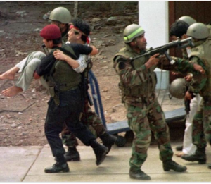
Japanese embassy hostage crisis
1996–1997 hostage crisis in Lima, Peru
Distance: Approx. 1747 meters
Latitude and longitude: -12.09138889,-77.04944444
The Japanese embassy hostage crisis (Spanish: Toma de la residencia del embajador de Japón en Lima, Japanese: 在ペルー日本大使公邸占拠事件, romanized: Zai Perū Nihon taishi kōtei senkyo jiken) began on 17 December 1996 in Lima, Peru, when 14 terrorist members of the Túpac Amaru Revolutionary Movement (MRTA) took hostage hundreds of high-level diplomats, government and military officials and business executives. They were attending a party at the official residence of the Japanese ambassador to Peru, Morihisa Aoki, in celebration of Emperor Akihito's 63rd birthday. Although the crisis took place at the ambassadorial residence in San Isidro rather than at the embassy proper, it is often referred to as the "Japanese embassy" hostage crisis.

San Isidro District, Lima
District of Lima, Peru
Distance: Approx. 833 meters
Latitude and longitude: -12.09916667,-77.03472222
San Isidro is an upscale district of the Lima Province in Peru. It is located in the west center of the city, it has a few meters of coastline. Officially created on April 24, 1931, San Isidro, along with Orrantia and Country Club neighbourhoods, was separated from Miraflores.

Universidad del Pacífico (Peru)
University in Lima, Peru
Distance: Approx. 1849 meters
Latitude and longitude: -12.08388889,-77.04833333
Universidad del Pacifico (UP) is a private university in the Jesús María District of Lima, Peru. It was established in 1962 by a group of Peruvian entrepreneurs supported by the Society of Jesus. Ranked as the most prestigious higher education institution in its fields of specialization in Peru (especially in economics), it's also one of the leading institutions of its kind in Latin American and is the first Peruvian university to be AACSB accredited in both undergraduate and graduate degree programs.

Museum of Natural History, Lima
Museum in Lima, Peru
Distance: Approx. 1645 meters
Latitude and longitude: -12.0775,-77.03722222
The Natural History Museum (Spanish: Museo de Historia Natural) in Lima, is Peru's most important museum of natural history. It was established in 1918 and belongs to the National University of San Marcos.

Chocavento Tower
Office in Lima, Peru
Distance: Approx. 1526 meters
Latitude and longitude: -12.0976,-77.0207
The Chocavento Tower (Edificio Chocavento) is a high-rise office building located in the San Isidro district of Lima, Peru, built in 2001. At a height of 107 meters, is the third highest building in Peru, surpassed by the "Centro Civico de Lima" (Civic center of Lima) at 109 meters, the "Westin Libertador Hotel" at 120 meters and the "Banco Continental (BBVA) Building" at 132 meters. The Chocavento building has 25 storeys above ground and five below ground.
List of ambassadors of China to Peru
Distance: Approx. 1791 meters
Latitude and longitude: -12.097059,-77.048951
The Ambassador Extraordinary and Plenipotentiary of the People's Republic of China to the Republic of Peru is the official representative of the People's Republic of China to the Republic of Peru. The ambassador in Lima, appointed by the Chairman of the Standing Committee of the National People's Congress (NPCSC), services the Embassy of the People's Republic of China in Peru.
Embassy of Sweden, Lima
Diplomatic mission of Sweden in Peru
Distance: Approx. 1233 meters
Latitude and longitude: -12.10253,-77.03621
The Embassy of Sweden in Lima was Sweden's diplomatic mission in Peru. Diplomatic relations between Peru and Sweden were established in 1930 and the embassy opened the following year. It was closed in 2001 and reopened in 2016, only to close again in 2022.

The Westin Lima Hotel & Convention Center
Building in Lima, Peru
Distance: Approx. 963 meters
Latitude and longitude: -12.09159,-77.02456
The Westin Lima Hotel & Convention Center, also known as the Hotel Westin Libertador, is a five-star hotel in San Isidro District, Lima. The hotel is owned by the Grupo Brescia and operated by Westin Hotels & Resorts.

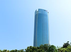
Begonias Tower
Building in Lima, Peru
Distance: Approx. 790 meters
Latitude and longitude: -12.0920905,-77.0261471
Begonias Tower, also known as the HSBC Tower, is a skyscraper located in San Isidro District, Lima.

Rospigliosi Castle
Landmark and museum in Lima, Peru
Distance: Approx. 1489 meters
Latitude and longitude: -12.07843,-77.03303
Rospigliosi Castle (Spanish: Castillo Rospigliosi) is a castle and museum in the neighbourhood of Santa Beatriz in Lima District, Lima, Peru. Since 1959, part of the castle is occupied by the Aeronautical Museum of Peru (Spanish: Museo Aeronáutico del Perú), previously housed at Las Palmas Air Base.

El Olivar, Peru
Park in Lima, Peru
Distance: Approx. 1108 meters
Latitude and longitude: -12.10166667,-77.03472222
El Olivar is a public park located in the neighbourhood of the same name in San Isidro District, Lima, Peru. Named after the olive trees located there since their introduction in 1560, it is part of the cultural heritage of Peru.

Heroes of Independence Park
Park in Lima, Peru
Distance: Approx. 1476 meters
Latitude and longitude: -12.08222222,-77.04277778
Heroes of Independence Park (Spanish: Parque Próceres de la Independencia), originally known as Matamula Forest (Spanish: Bosque Matamula), is a public park next to Salaverry Avenue in Jesús María District, Lima.
Weather in this IP's area
scattered clouds
20 Celsius
20 Celsius
18 Celsius
20 Celsius
1014 hPa
80 %
1014 hPa
1000 hPa
10000 meters
5.14 m/s
160 degree
40 %
05:32:50
18:12:41