38.52.165.151 - IP Lookup: Free IP Address Lookup, Postal Code Lookup, IP Location Lookup, IP ASN, Public IP
Country:
Region:
City:
Location:
Time Zone:
Postal Code:
IP information under different IP Channel
ip-api
Country
Region
City
ASN
Time Zone
ISP
Blacklist
Proxy
Latitude
Longitude
Postal
Route
Luminati
Country
Region
mi
City
wyandotte
ASN
Time Zone
America/Detroit
ISP
WYAN-AS
Latitude
Longitude
Postal
IPinfo
Country
Region
City
ASN
Time Zone
ISP
Blacklist
Proxy
Latitude
Longitude
Postal
Route
IP2Location
38.52.165.151Country
Region
michigan
City
wyandotte
Time Zone
America/Detroit
ISP
Language
User-Agent
Latitude
Longitude
Postal
db-ip
Country
Region
City
ASN
Time Zone
ISP
Blacklist
Proxy
Latitude
Longitude
Postal
Route
ipdata
Country
Region
City
ASN
Time Zone
ISP
Blacklist
Proxy
Latitude
Longitude
Postal
Route
Popular places and events near this IP address

Wyandotte, Michigan
City in Michigan, United States
Distance: Approx. 2244 meters
Latitude and longitude: 42.20861111,-83.1625
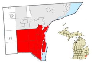
Wyandotte ( WY-ən-dot) is a city in Wayne County in the U.S. state of Michigan. The population was 25,058 at the 2020 census. Wyandotte is located in southeastern Michigan, approximately 11 miles (18 km) south of Detroit on the Detroit River, and it is part of the collection of communities known as Downriver.

Southgate, Michigan
City in Michigan, United States
Distance: Approx. 1369 meters
Latitude and longitude: 42.20527778,-83.19805556
Southgate is a city in Wayne County, Michigan, United States. The population was 30,047 at the 2020 census. Southgate was incorporated as a city on October 8, 1958, which was one of the last remaining portions of the now-defunct Ecorse Township.

Downriver
Metro Detroit in Michigan, United States
Distance: Approx. 1369 meters
Latitude and longitude: 42.20527778,-83.19805556
Downriver is a region of the Detroit metropolitan area in the U.S. state of Michigan. Most definitions of the region include the communities in Wayne County, south of Detroit, along the western shore of the Detroit River.

Theodore Roosevelt High School (Michigan)
High school in Wyandotte, Michigan, United States
Distance: Approx. 2358 meters
Latitude and longitude: 42.201,-83.157
Theodore Roosevelt High School, also known as RHS or Roosevelt, or also Wyandotte High by alumni, is the secondary school serving Wyandotte, Michigan, located on Eureka Road several blocks west of Biddle Avenue. The corner stone of Roosevelt High School was laid in the fall of 1921. Roosevelt did not open its doors to students until April 1923.

Southgate Shopping Center
Shopping center in Michigan, United States
Distance: Approx. 462 meters
Latitude and longitude: 42.1977,-83.1908
Southgate Shopping Center is a shopping center located at the southeast corner of Eureka and Trenton Roads in Southgate, Michigan. Completed by 1958, it was one of the first major strip malls in the southern Detroit suburbs until the nearby Southland Center opened in 1970. At its peak, the center housed over thirty stores.
Our Lady of Mount Carmel Church (Wyandotte, Michigan)
Church in Michigan, United States
Distance: Approx. 1949 meters
Latitude and longitude: 42.20623,-83.16472
Our Lady of Mount Carmel Church (Polish: Kościół Matki Bożej Szkaplerznej) is located at 976 Pope John Paul II Ave. in the Detroit suburb of Wyandotte, Michigan. Following a parish merger on August 1, 2013, Our Lady of Mount Carmel Church serves the Roman Catholic Polish Personal Parish of Our Lady of the Scapular.

Southgate Anderson High School
High school in Southgate, Michigan
Distance: Approx. 2326 meters
Latitude and longitude: 42.191,-83.212
Southgate Thomas J. Anderson High School is a public high school in Southgate, Michigan, United States. A part of the Southgate Community School District, it serves Southgate and a section of Allen Park.

Our Lady of Mount Carmel High School (Wyandotte, Michigan)
Private, coeducational school in Wyandotte, , Michigan, United States
Distance: Approx. 2009 meters
Latitude and longitude: 42.20694444,-83.16444444
Our Lady of Mount Carmel High School, (Polish: Matki Bożej Szkaplerznej Wyższej Szkoły) was a private, Roman Catholic high school in Wyandotte, Michigan to the parish of Our Lady of Mount Carmel. It was closed in June, 2011 by the Archdiocese of Detroit.
Riverview Community High School
Distance: Approx. 2401 meters
Latitude and longitude: 42.1767,-83.1775
Riverview Community High School (RCHS) is a public high school in Riverview, Michigan, United States. It is a current member of the Huron League. The school is a part of the Riverview Community School District.

Old Homestead, Southgate, Michigan
Place in Michigan, United States
Distance: Approx. 318 meters
Latitude and longitude: 42.2,-83.18333333
Old Homestead is a neighborhood on the east side of the Metro Detroit suburb of Southgate, Michigan. Usually, Old Homestead is bordered by Superior Street to the north, Eureka Road to the south, M-85 (Fort Street) to the east and either Trenton Road or Burns Street to the west. Commercial districts are located along Eureka Road and Fort Street and the rest of the neighborhood is mostly single-family homes, most of which were built during the 1940s and 1950s.

McKinley Elementary School (Wyandotte, Michigan)
United States historic place
Distance: Approx. 2198 meters
Latitude and longitude: 42.19611111,-83.15861111
McKinley Elementary School is a former school building located at 640 Plum Street in Wyandotte, Michigan. It was listed on the National Register of Historic Places in 2017.

Southgate Tower
Office, retail (former), Residential (planned) in Southgate-Detroit, United States
Distance: Approx. 1103 meters
Latitude and longitude: 42.18861111,-83.19111111
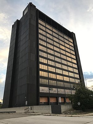
Southgate Tower is a high-rise office building at 16333 Trenton Road in Southgate, Michigan. Since its completion, it has been the tallest building in the Downriver area of Wayne County, Michigan, as well as the tallest building between Detroit and Toledo, Ohio. A large portion of office space in the building was occupied by PNC Financial Services.
Weather in this IP's area
overcast clouds
1 Celsius
1 Celsius
-0 Celsius
2 Celsius
1029 hPa
93 %
1029 hPa
1006 hPa
10000 meters
0.51 m/s
240 degree
100 %
