Country:
Region:
City:
Latitude and Longitude:
Time Zone:
Postal Code:
IP information under different IP Channel
ip-api
Country
Region
City
ASN
Time Zone
ISP
Blacklist
Proxy
Latitude
Longitude
Postal
Route
Luminati
Country
Region
hid
City
atotonilcodetula
ASN
Time Zone
America/Mexico_City
ISP
IENTC S DE RL DE CV
Latitude
Longitude
Postal
IPinfo
Country
Region
City
ASN
Time Zone
ISP
Blacklist
Proxy
Latitude
Longitude
Postal
Route
db-ip
Country
Region
City
ASN
Time Zone
ISP
Blacklist
Proxy
Latitude
Longitude
Postal
Route
ipdata
Country
Region
City
ASN
Time Zone
ISP
Blacklist
Proxy
Latitude
Longitude
Postal
Route
Popular places and events near this IP address
Atitalaquía
Municipality in Hidalgo, Mexico
Distance: Approx. 8195 meters
Latitude and longitude: 20.05833333,-99.22083333
Atitalaquía is a town and one of the 84 municipalities of Hidalgo, in central-eastern Mexico. The municipality covers an area of 64.2 km2 (24.8 sq mi). As of 2010 census, the municipality had a total population of 26,749.

Atotonilco de Tula
Municipality and city in Hidalgo, Mexico
Distance: Approx. 6693 meters
Latitude and longitude: 20.05,-99.18333333
Atotonilco de Tula is one of the 84 municipalities of Hidalgo. It is located in the southwestern part of the state of Hidalgo in Mexico. The municipal seat is Atotonilco de Tula.

Apaxco
Municipality and town in Mexico, Mexico
Distance: Approx. 4430 meters
Latitude and longitude: 19.98,-99.15
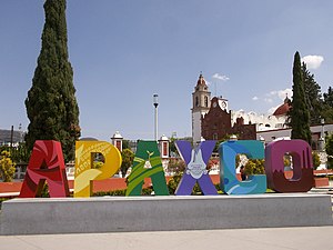
Apaxco (Otomi: Pixkuai) is a municipality located in the Zumpango Region (northeastern part of the State of Mexico) in Mexico. The municipal territory is located at a southern pass leading out of the Mezquital Valley about 288 km (179 mi) northeast of the state capital of Toluca. The name Apaxco comes from Nahuatl (meaning "place of the water fall").

Santiago Apóstol Parish (Tequixquiac)
Church in Santiago Tequixquiac, Mexico
Distance: Approx. 9994 meters
Latitude and longitude: 19.91034,-99.14748
Santiago Apóstol parish is the Catholic church and parish house of the people of downtown Santiago Tequixquiac, in the Diocese of Cuautitlán in Mexico It is dedicated to Saint James Apostle and includes a sanctuary where the image of Lord of the Chapel is venerated. It is located in the center of town, near Plaza Cuautémoc, by Juárez Avenue. The colonial building in the municipality of Tequixquiac is a monument of great architectural importance, remaining intact to this day.
Cerro Mesa Ahumada
Distance: Approx. 9940 meters
Latitude and longitude: 19.90111111,-99.18638889
Cerro Mesa Ahumada (Mesa Ahumada Hill), also known as Cerro Colorado, is a hill located in the northern region of the State of Mexico (Estado de Mexico or Edomex). It is located between the municipalities of Tequixquiac and Apaxco. This hill has a maximum elevation of 2,600 metres (8,500 ft) above sea level and is located at a southern pass leading out of the Mezquital Valley.

Apaxco de Ocampo (town)
Municipal Seat in State of Mexico, Mexico
Distance: Approx. 2889 meters
Latitude and longitude: 19.97333333,-99.17
Apaxco de Ocampo is a town and the municipal seat of the Apaxco municipality, Mexico State in Mexico. As of 2010, the town has a population of 13,836.
Weather in this IP's area
broken clouds
16 Celsius
15 Celsius
16 Celsius
16 Celsius
1012 hPa
53 %
1012 hPa
789 hPa
10000 meters
1.06 m/s
1.17 m/s
161 degree
51 %
06:47:15
17:56:44

