38.26.28.238 - IP Lookup: Free IP Address Lookup, Postal Code Lookup, IP Location Lookup, IP ASN, Public IP
Country:
 Canada
Region:
City:
Location:
Time Zone:
Postal Code:
ISP:
ASN:
language:
User-Agent:
Proxy IP:
Blacklist:
IP information under different IP Channel
ip-api
Country
Region
City
ASN
Time Zone
ISP
Blacklist
Proxy
Latitude
Longitude
Postal
Route
db-ip
Country
Region
City
ASN
Time Zone
ISP
Blacklist
Proxy
Latitude
Longitude
Postal
Route
IPinfo
Country
Region
City
ASN
Time Zone
ISP
Blacklist
Proxy
Latitude
Longitude
Postal
Route
IP2Location
38.26.28.238Country
caRegion
ontario
City
toronto
Time Zone
America/Toronto
ISP
Language
User-Agent
Latitude
Longitude
Postal
ipdata
Country
Region
City
ASN
Time Zone
ISP
Blacklist
Proxy
Latitude
Longitude
Postal
Route
Popular places and events near this IP address

Wexford, Toronto
Neighbourhood in Toronto, Ontario, Canada
Distance: Approx. 1574 meters
Latitude and longitude: 43.74305556,-79.30444444
Wexford is a neighbourhood in Toronto, Ontario, Canada. It is located in the eastern part of the city, on the western end of the district of Scarborough, spanning Lawrence Avenue East between Victoria Park Avenue and Birchmount Road. There are many persons of Greek heritage in this neighbourhood.

Don Valley East (federal electoral district)
Federal electoral district in Ontario, Canada
Distance: Approx. 660 meters
Latitude and longitude: 43.74,-79.33
Don Valley East (French: Don Valley-Est) is a federal electoral district in Ontario, Canada that covers the northeast section of the North York part of Toronto. The federal riding was created in 1976 from parts of Willowdale, York East, York North, and York—Scarborough ridings. It is represented in the House of Commons of Canada by Liberal MP Michael Coteau.

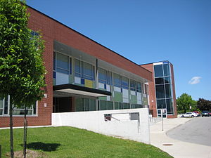
Don Mills Collegiate Institute
High school in Toronto, Ontario, Canada
Distance: Approx. 1355 meters
Latitude and longitude: 43.73587778,-79.33917778
Don Mills Collegiate Institute is a high school in Toronto, Ontario, Canada. Located in the Don Mills neighbourhood, it serves an ethnically diverse student population of approximately 1000. As of 2017, 67% of students speak a first language other than English.
Senator O'Connor College School
High school in North York, Toronto, Ontario, Canada
Distance: Approx. 1515 meters
Latitude and longitude: 43.750677,-79.317303
Senator O'Connor College School (also called SOCS, Senator O'Connor CS, Senator O'Connor, OCS, or simply Senator or O'Connor), previously known as John J. Lynch High School until 1967 is a Separate high school in the Parkwoods neighbourhood in the North York district of Toronto, Ontario, Canada serving grades 9 to 12 in the communities of Wexford, Maryvale, Don Mills, and Dorset Park. The school was named after Senator Frank O'Connor, founder of the Laura Secord chocolate company. The school is part of the Toronto Catholic District School Board and was originally founded as John J. Lynch High School in 1963, named after the first archbishop of Toronto from 1870 to 1888, John Joseph Lynch.

Don Mills Middle School
Public middle school in Toronto, Ontario, Canada
Distance: Approx. 1363 meters
Latitude and longitude: 43.73605556,-79.33930556
Don Mills Middle School (DMMS) is a middle school in Toronto, Ontario. It is located near the intersection Don Mills Road and Lawrence Avenue. The school was known as Don Mills Junior High School until 1986.

Victoria Village
Neighbourhood in Toronto, Ontario, Canada
Distance: Approx. 836 meters
Latitude and longitude: 43.73555556,-79.3125
For the settlement established by former slaves in Guyana known as Victoria Village see Victoria, Guyana Victoria Village, sometimes referred to as Sloane (after the main street within the area), is a neighbourhood in the city of Toronto, Ontario, Canada bounded on the west by the Don Valley, on the north by Lawrence Avenue East, on the east by Victoria Park Avenue, and on the south by Eglinton Avenue East, although there is a small area south of Eglinton to Sunrise Avenue that is sometimes included. It is located in the southeast of the former city of North York. Its population is diverse in ancestral backgrounds with a larger proportion of South Americans than most of the city.

Parkwoods
Neighbourhood in Toronto, Ontario, Canada
Distance: Approx. 1492 meters
Latitude and longitude: 43.751,-79.323
Parkwoods or sometimes referred to as Parkwoods-Donalda, is a neighbourhood in Toronto, Ontario, Canada. It is a geographically large neighbourhood located just south of Ontario Highway 401, west of Victoria Park Avenue, north of Lawrence Avenue East and east of the Don Valley Parkway.

Don Valley East (provincial electoral district)
Provincial electoral district in Ontario, Canada
Distance: Approx. 660 meters
Latitude and longitude: 43.74,-79.33
Don Valley East is a provincial electoral district in Toronto, Ontario, Canada. It elects one member to the Legislative Assembly of Ontario. It was created in 1999 from parts of Don Mills, York Mills, Oriole and Willowdale.
Maryvale, Toronto
Neighbourhood in Toronto, Ontario, Canada
Distance: Approx. 1574 meters
Latitude and longitude: 43.74305556,-79.30444444
Maryvale is a neighbourhood in Toronto, Ontario, Canada. It is located on the western edge of the Scarborough district, with its western border being Victoria Park Avenue. To the north it is bordered by Highway 401, to the east by Warden and to the south by railroad tracks.
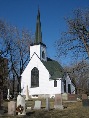
Church of St. Jude (Wexford)
Church in Ontario, Canada
Distance: Approx. 1337 meters
Latitude and longitude: 43.73873,-79.30595
The Church of St. Jude is an historic church in the Scarborough area of Toronto, Ontario, Canada. St.

Noor Cultural Centre
Distance: Approx. 1366 meters
Latitude and longitude: 43.72626,-79.329
The Noor Cultural Centre was an Islamic cultural centre located in the Don Mills neighbourhood in Toronto, Ontario, Canada, on the east side of the Don Valley Parkway just north of Eglinton Avenue. As of October 2021, the location was sold after 18 months of continuous lockdowns due to the pandemic, and the organization now maintains its activities virtually.

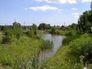
Milne Hollow
Park in Toronto, Canada
Distance: Approx. 976 meters
Latitude and longitude: 43.7391575,-79.3344418
Milne Hollow is a 50-hectare (120-acre) valley site in Toronto, Ontario, Canada within the valley of the East Don River. It is located in north-west central Toronto where the Don Valley Parkway intersects with Lawrence Avenue East. It was the location of pioneer Alexander Milne's mill town known as Milnesford Mills and his homestead farm.
Weather in this IP's area
clear sky
-12 Celsius
-19 Celsius
-13 Celsius
-10 Celsius
1020 hPa
71 %
1020 hPa
1003 hPa
10000 meters
5.66 m/s
12.35 m/s
360 degree