Country:
 Indonesia
Region:
City:
Latitude and Longitude:
Time Zone:
Postal Code:
IP information under different IP Channel
ip-api
Country
Region
City
ASN
Time Zone
ISP
Blacklist
Proxy
Latitude
Longitude
Postal
Route
IPinfo
Country
Region
City
ASN
Time Zone
ISP
Blacklist
Proxy
Latitude
Longitude
Postal
Route
MaxMind
Country
Region
City
ASN
Time Zone
ISP
Blacklist
Proxy
Latitude
Longitude
Postal
Route
Luminati
Country
 US
USASN
Time Zone
America/Chicago
ISP
PT Global Sarana Elektronika
Latitude
Longitude
Postal
db-ip
Country
Region
City
ASN
Time Zone
ISP
Blacklist
Proxy
Latitude
Longitude
Postal
Route
ipdata
Country
Region
City
ASN
Time Zone
ISP
Blacklist
Proxy
Latitude
Longitude
Postal
Route
Popular places and events near this IP address
Cipayung
District in Jakarta, Indonesia
Distance: Approx. 3174 meters
Latitude and longitude: -6.31666667,106.9
Cipayung is a district (kecamatan) of East Jakarta, Indonesia, situated in the southeastern part of Jakarta, in the outskirts of Jakarta. Its northern boundary is Pondok Gede Raya Road, its eastern boundary is Sunter River to the East, and its western boundary is Jagorawi Tollway. Marshes can still be found in Cipayung.

Ciracas
District in DKI Jakarta, Indonesia
Distance: Approx. 2145 meters
Latitude and longitude: -6.32694444,106.875
Ciracas is a district (kecamatan) of East Jakarta, one of the five administrative cities of Jakarta, Indonesia. Ciracas is the southernmost district in Jakarta. The area of Cibubur Scout's camping ground complex is located partly within the Ciracas District, although the main camping ground area is located in Cipayung District.
Pasar Rebo
Distance: Approx. 3936 meters
Latitude and longitude: -6.3277,106.8545
Pasar Rebo (literally Wednesday Market in Betawi) is a district (kecamatan) of East Jakarta, Indonesia. The boundaries of Pasar Rebo District are the Ciliwung to the west and north; and Bogor Raya Road and Cipinang River to the east. The city of Depok is located to the south of Pasar Rebo District.
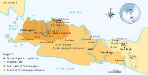
Tarumanagara
Former kingdom in Indonesia
Distance: Approx. 1737 meters
Latitude and longitude: -6.33333333,106.9
Tarumanagara or Taruma Kingdom or just Taruma was an early Sundanese Indianised kingdom, located in western Java, whose 5th-century ruler, Purnawarman, produced the earliest known inscriptions in Java, which are estimated to date from around 358 CE. At least seven stone inscriptions connected to this kingdom were discovered in Western Java area, near Bogor and Jakarta.
Jakarta Indonesia Korean School
Korean international school in Indonesia
Distance: Approx. 2834 meters
Latitude and longitude: -6.3174321,106.8934126
Jakarta Indonesia Korean School (JIKS, Korean: 자카르타한국국제학교), formerly Jakarta International Korean School, is a South Korean international school in East Jakarta, Indonesia. As of 2005 it is the largest overseas South Korean school, with 1,450 students. As of 2009 the school's student body is twice as large as that of the Korean International School, HCMC in Ho Chi Minh City, the next-largest South Korean international school.
Cimanggis
District in Java, Indonesia
Distance: Approx. 3963 meters
Latitude and longitude: -6.364455,106.859138
Cimanggis is an administrative district (kecamatan) within the city of Depok, in the province of West Java, Indonesia. Cimanggis is located in the north of Depok, immediately south of Jakarta. It covers an area of 21.78 km2 and had a population of 241,979 at the 2010 Census and 252,000 at the 2020 Census; the latest official estimate (as at mid 2023) is 252,370.
GOR Ciracas Stadium
Distance: Approx. 3017 meters
Latitude and longitude: -6.3252357,106.8656374
GOR Ciracas Stadium is a multi-purpose stadium in the city of East Jakarta, Indonesia. The stadium has a capacity of 5,000 people. It is the former home base of Villa 2000 After changed its name to Celebest FC in 2016 and moved to its current stadium in Gawalise Stadium in the same year.
Trans Studio Cibubur
Mixed-development complex in Indonesia
Distance: Approx. 4078 meters
Latitude and longitude: -6.375656,106.901736
Trans Studio Cibubur is mixed development complex at Harjamukti, Cimanggis, Depok, West Java within Jakarta Metropolitan Area. Trans Studio Cibubur is built on 4.1 ha (10 acres). The complex has several sections, a shopping mall, a recreation park called Trans Studio Theme Park, Trans Park (three apartment towers) and a luxury hotel called Trans Studio Hotel.
POPKI Sports Hall
Multifunction sports arena in Indonesia
Distance: Approx. 2871 meters
Latitude and longitude: -6.3676934,106.8899999
POPKI Sports Hall (Indonesian: Gelanggang Olahraga POPKI) or commonly known as is GOR POPKI a multifunction sports arena in Cibubur, Ciracas, East Jakarta, Jakarta, Indonesia. This arena can be used for basketball, badminton, volleyball, futsal, and taekwondo venues.

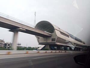
Harjamukti LRT Station
Light rail station in west Java
Distance: Approx. 3678 meters
Latitude and longitude: -6.373988,106.895623
Harjamukti LRT Station (HAR) is a light rail station located in Harjamukti, Cimanggis, Depok, West Java. This station, which is operated by PT Kereta Api Indonesia (Persero), is the terminus station of the Cibubur Line, which is part of LRT Jabodebek. Commuters along The Transyogi Road (which is a major road) are also served by this LRT station.

Kampung Rambutan LRT Station
LRT station in Indonesia
Distance: Approx. 3634 meters
Latitude and longitude: -6.309541,106.884325
Kampung Rambutan LRT Station is a light rail station located in Jalan Bungur, Rambutan, Ciracas, East Jakarta. The station serves the Cibubur line of the Jabodebek LRT system. The station is located inside the Kampung Rambutan Bus Terminal itself, hence the station name.
Ciracas LRT Station
LRT station in Indonesia
Distance: Approx. 2046 meters
Latitude and longitude: -6.3237,106.8867
Ciracas LRT Station is a light rail station located in Jalan Cikago, Ciracas, Ciracas, East Jakarta. The station serves the Cibubur line of the Jabodebek LRT system.
Weather in this IP's area
few clouds
29 Celsius
31 Celsius
27 Celsius
30 Celsius
1014 hPa
64 %
1014 hPa
1007 hPa
6000 meters
2.06 m/s
190 degree
20 %
05:29:00
17:45:08