Country:
 Great Britain
Region:
City:
Latitude and Longitude:
Time Zone:
Postal Code:
IP information under different IP Channel
ip-api
Country
Region
City
ASN
Time Zone
ISP
Blacklist
Proxy
Latitude
Longitude
Postal
Route
IPinfo
Country
Region
City
ASN
Time Zone
ISP
Blacklist
Proxy
Latitude
Longitude
Postal
Route
MaxMind
Country
Region
City
ASN
Time Zone
ISP
Blacklist
Proxy
Latitude
Longitude
Postal
Route
Luminati
Country
GBRegion
eng
City
towerhamlets
ASN
Time Zone
Europe/London
ISP
Krixe Pte. Ltd.
Latitude
Longitude
Postal
db-ip
Country
Region
City
ASN
Time Zone
ISP
Blacklist
Proxy
Latitude
Longitude
Postal
Route
ipdata
Country
Region
City
ASN
Time Zone
ISP
Blacklist
Proxy
Latitude
Longitude
Postal
Route
Popular places and events near this IP address

Poplar, London
Area of East London, England
Distance: Approx. 154 meters
Latitude and longitude: 51.5066,-0.0178
Poplar is a district in East London, England and is in the London Borough of Tower Hamlets. It is an inner-city suburb located five miles (8 km) east of Charing Cross and lays on the western bank of the River Lea and is part of the London Docklands. Poplar is identified as a major district centre in the London Plan, with its district centre being Chrisp Street Market, a significant commercial and retail centre surrounded by extensive residential development.

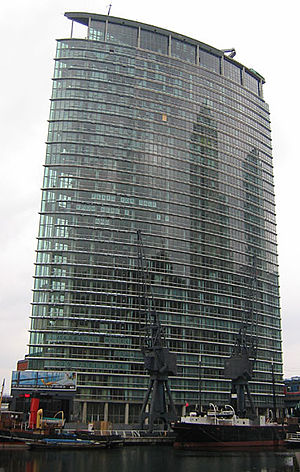
One Canada Square
Skyscraper in Canary Wharf, London
Distance: Approx. 158 meters
Latitude and longitude: 51.505,-0.01961111
One Canada Square is a skyscraper in Canary Wharf, London. It is the third tallest building in the United Kingdom at 770 feet (235 m) above ground level, and contains 50 storeys. It achieved the title of the tallest building in the UK upon completion in 1991 and held the title for 21 years until the completion of The Shard (310m) in 2012.

Canary Wharf DLR station
Railway station in East London, England
Distance: Approx. 158 meters
Latitude and longitude: 51.5051,-0.0209
Canary Wharf is a Docklands Light Railway (DLR) station in Canary Wharf in East London. Located next to One Canada Square and between two parts of a shopping centre (Cabot Place), it serves the Canary Wharf office complex. Each of its three tracks feature platforms on both sides, allowing for easy interchanges and access to surrounding buildings.
1 West India Quay
Building in London, England
Distance: Approx. 120 meters
Latitude and longitude: 51.50722222,-0.02111111
1 West India Quay is a landmark 33-storey mixed-use skyscraper situated just north of Canary Wharf business district in east London. Completed in 2004, the development was built by Manhattan Loft Corporation and the now-defunct MWB Group Holdings. The distinctive glass- and aluminium-clad tower was designed by HOK. With its knife-edge profile and elegant curves, 1 West India Quay was one of the first post-tensioned, concrete-framed towers in London.

Canada Square
Square at Canary Wharf, London, England
Distance: Approx. 168 meters
Latitude and longitude: 51.504936,-0.019423
Canada Square is a square at Canary Wharf in the London Borough of Tower Hamlets, located in London. Canada Square is surrounded by three of the tallest buildings in the United Kingdom, including One Canada Square, which was the tallest building in the United Kingdom from 1990 until late 2010, when it was surpassed by The Shard in the London Borough of Southwark. The complex is named for Canada by Olympia and York, the original developers of the site owned by the Reichmann family of Toronto.

West India Quay DLR station
Docklands Light Railway station
Distance: Approx. 60 meters
Latitude and longitude: 51.50687,-0.020425
West India Quay is a Docklands Light Railway (DLR) station in Canary Wharf’s West India Quay. It is located at the point where the line from Lewisham splits into branches to Tower Gateway/Bank and Stratford. The next stations on each line are Canary Wharf DLR station (to Lewisham), Westferry (to Tower Gateway/Bank) and Poplar DLR station (to Stratford).

West India Quay
Human settlement in England
Distance: Approx. 157 meters
Latitude and longitude: 51.50666667,-0.02222222
West India Quay is an area in the London Docklands, London, England. It is immediately to the north of the West India Docks and Canary Wharf. The warehouse at West India Quay was used to store imported goods from the West Indies, such as tea, sugar and rum, and is now a Grade I listed building.

5 Canada Square
Office building in Canary Wharf, London, England
Distance: Approx. 134 meters
Latitude and longitude: 51.505556,-0.018611
5 Canada Square is a 15-storey, 87.7 m (288 ft) office building in the Canary Wharf financial district development of London, England.
North Quay, London
Distance: Approx. 113 meters
Latitude and longitude: 51.50699722,-0.01868889
North Quay is an approved office development, consisting of three towers on the north side of Canary Wharf in London. The developer is Canary Wharf Group and the architect is Cesar Pelli. The original plan was for three towers of 18, 38 and 40 floors.
25 North Colonnade
Building in Canary Wharf, London
Distance: Approx. 70 meters
Latitude and longitude: 51.50577778,-0.02013889
25 North Colonnade is a commercial building in Canary Wharf, London formerly occupied by the Financial Conduct Authority, after having been solely occupied by its predecessor, the Financial Services Authority (FSA) until early 2013. It is 80 metres (262 ft) tall, with 15 floors. Built in 1991, its developer was the Canary Wharf Group, and its architect was Troughton McAslan.

Marriott Canary Wharf
Hotel in London
Distance: Approx. 96 meters
Latitude and longitude: 51.50695,-0.02107
The London Marriott Hotel Canary Wharf (previously Marriott Hotel West India Quay) is a hotel in Canary Wharf in London, England, that opened in 2004. It is located at 1 West India Quay, 22 Hertsmere Road, and is named after Canary Wharf where it overlooks West India Dock North. It is operated by Marriott Hotels, and has 301 rooms and 47 serviced apartments.

UCL School of Management
Business school of University College London
Distance: Approx. 158 meters
Latitude and longitude: 51.505,-0.01961111
The UCL School of Management is the business school of University College London (UCL). The School offers undergraduate, postgraduate, PhD and executive programmes in management, entrepreneurship, business analytics, business information systems, and finance.
Weather in this IP's area
few clouds
15 Celsius
15 Celsius
14 Celsius
16 Celsius
1019 hPa
63 %
1019 hPa
1019 hPa
10000 meters
2.57 m/s
160 degree
20 %
07:06:00
18:31:11