Country:
 USA
USARegion:
City:
Latitude and Longitude:
Time Zone:
Postal Code:
IP information under different IP Channel
ip-api
Country
Region
City
ASN
Time Zone
ISP
Blacklist
Proxy
Latitude
Longitude
Postal
Route
IPinfo
Country
Region
City
ASN
Time Zone
ISP
Blacklist
Proxy
Latitude
Longitude
Postal
Route
MaxMind
Country
Region
City
ASN
Time Zone
ISP
Blacklist
Proxy
Latitude
Longitude
Postal
Route
Luminati
Country
USRegion
il
City
chicago
ASN
Time Zone
America/Chicago
ISP
Krixe Pte. Ltd.
Latitude
Longitude
Postal
db-ip
Country
Region
City
ASN
Time Zone
ISP
Blacklist
Proxy
Latitude
Longitude
Postal
Route
ipdata
Country
Region
City
ASN
Time Zone
ISP
Blacklist
Proxy
Latitude
Longitude
Postal
Route
Popular places and events near this IP address

St. Ignatius College Prep
Private college-preparatory school in Chicago, Illinois, United States
Distance: Approx. 628 meters
Latitude and longitude: 41.8675,-87.65416667
Saint Ignatius College Prep is a private, coeducational Jesuit college-preparatory school located in the Near West Side neighborhood of Chicago, Illinois. The school was founded in Chicago in 1869 by Fr. Arnold Damen, S.J., a Dutch missionary to the United States.

Credit Union 1 Arena
Arena in Chicago, United States
Distance: Approx. 390 meters
Latitude and longitude: 41.87472222,-87.65611111
Credit Union 1 Arena (previously known as UIC Pavilion) is a multi-purpose arena located at 525 S. Racine Avenue on the Near West Side in Chicago, Illinois. It opened in 1982.

Little Italy, Chicago
Human settlement in Illinois, United States of America
Distance: Approx. 101 meters
Latitude and longitude: 41.871,-87.659
Little Italy, sometimes combined with University Village into one neighborhood, is on the Near West Side of Chicago, Illinois. The current boundaries of Little Italy are Ashland Avenue on the west and Interstate 90/94 on the east, the Eisenhower Expressway on the north and Roosevelt to the south. It lies between the east side of the University of Illinois at Chicago campus in the Illinois Medical District and the west side of the University of Illinois at Chicago campus.

Racine station (CTA Blue Line)
Chicago "L" station
Distance: Approx. 449 meters
Latitude and longitude: 41.8759,-87.6596
Racine is an 'L' station on the CTA's Blue Line. The station serves the Near West Side neighborhood and the western end of the UIC campus.

Holy Family Catholic Church (Chicago)
Roman Catholic church in Chicago, Illinois
Distance: Approx. 601 meters
Latitude and longitude: 41.8675,-87.6547
Holy Family Catholic Church is a Catholic church in Chicago, Illinois. It is the second-oldest such church in the city and one of the few structures that survived the Great Chicago Fire. The Society of Jesus leased the Church to the Archdiocese of Chicago, who operated the parish.

Jennie Foley Building
United States historic place
Distance: Approx. 227 meters
Latitude and longitude: 41.87333333,-87.65694444
The Jennie Foley Building, also known as the Jennie Foley-Victor A. Arrigo Building, is a historic commercial and residential building located at 626-628 S. Racine Ave. in Chicago, Illinois. Built in 1889, the four-story building has a storefront on its first floor and six apartments on its upper stories.
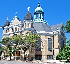
Notre Dame de Chicago
Historic church in Illinois, United States
Distance: Approx. 226 meters
Latitude and longitude: 41.87333333,-87.66083333
Notre Dame de Chicago is a Roman Catholic church in the Near West Side community area of Chicago, Illinois. The church was built from 1889 to 1892, replacing an earlier church built in 1865 at a different site. French Canadian architect Gregoire Vigeant designed the church in the Romanesque Revival style; the design has a heavy French influence which can be seen in its Greek cross layout, its hipped roofs and square domes, and the emphasis on height suggested by its two cupolas and its lantern.
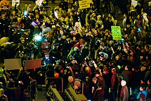
2016 Donald Trump Chicago rally protest
Distance: Approx. 390 meters
Latitude and longitude: 41.87472222,-87.65611111
On March 11, 2016, the Donald Trump presidential campaign canceled a planned rally at the University of Illinois Chicago (UIC), in Chicago, Illinois, citing "growing safety concerns" due to the presence of thousands of protesters inside and outside his rally. Thousands of anti-Trump demonstrators responding to civic leaders' and social media calls to shut the rally down had gathered outside the arena, and several hundred more filled seating areas within the UIC Pavilion, where the rally was to take place. When the Trump campaign announced that the rally would not take place, there was a great deal of shouting and a few small scuffles between Trump supporters and anti-Trump protesters.
National Public Housing Museum
Museum in Chicago, USA
Distance: Approx. 264 meters
Latitude and longitude: 41.86963889,-87.65986111
The National Public Housing Museum is a historical institution that will be opening at 1322 W Taylor St. in Chicago, Illinois, and currently is located at 625 N Kingsbury St. in Chicago.

Laflin station
Rapid transit station in Chicago, 1895–1951
Distance: Approx. 622 meters
Latitude and longitude: 41.87585,-87.664212
Laflin was a rapid transit station operated by the Chicago "L"'s Metropolitan West Side Elevated Railroad and located on its main line. The station existed from 1895 to 1951, when it was closed due to low ridership. The entire main line would soon be demolished for construction of the Eisenhower Expressway and its Congress Line, and the niche served by the Laflin would be filled by an entrance on the new line's Racine station.
Racine station (CTA Metropolitan Main Line)
Rapid transit station in Chicago, 1895–1954
Distance: Approx. 450 meters
Latitude and longitude: 41.87592,-87.659458
Racine was a rapid transit station operated by the Chicago "L"'s Metropolitan West Side Elevated Railroad and located on its main line. The station existed from 1895 to 1954, when it and the other stations on the main line were demolished for construction of the Eisenhower Expressway and its Congress Line. A new station at Racine was built on the Congress Line as a replacement.
Tufano's Vernon Park Tap
Italian restaurant in Chicago, Illinois, U.S.
Distance: Approx. 419 meters
Latitude and longitude: 41.872916,-87.654028
Tufano's Vernon Park Tap is an Italian restaurant in Chicago, Illinois, United States. Joey DiBuono is the owner. The restaurant has appeared on the Food Network series Diners, Drive-Ins and Dives.
Weather in this IP's area
broken clouds
20 Celsius
20 Celsius
18 Celsius
21 Celsius
1024 hPa
59 %
1024 hPa
1003 hPa
10000 meters
5.14 m/s
50 degree
75 %
06:51:09
18:26:59