Country:
Region:
City:
Latitude and Longitude:
Time Zone:
Postal Code:
IP information under different IP Channel
ip-api
Country
Region
City
ASN
Time Zone
ISP
Blacklist
Proxy
Latitude
Longitude
Postal
Route
Luminati
Country
Region
qc
City
quebec
ASN
Time Zone
America/Toronto
ISP
OXIO-ASN-01
Latitude
Longitude
Postal
IPinfo
Country
Region
City
ASN
Time Zone
ISP
Blacklist
Proxy
Latitude
Longitude
Postal
Route
db-ip
Country
Region
City
ASN
Time Zone
ISP
Blacklist
Proxy
Latitude
Longitude
Postal
Route
ipdata
Country
Region
City
ASN
Time Zone
ISP
Blacklist
Proxy
Latitude
Longitude
Postal
Route
Popular places and events near this IP address

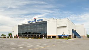
Colisée de Québec
Multi-purpose arena in Quebec City
Distance: Approx. 161 meters
Latitude and longitude: 46.83083333,-71.24638889
Colisée de Québec (later known as Colisée Pepsi, meaning "Pepsi Coliseum") was a multi-purpose arena located in Quebec City, Quebec. It was the home of the Quebec Nordiques from 1972 to 1995, during their time in the World Hockey Association and National Hockey League. It was also the home of the Quebec Remparts of the Quebec Major Junior Hockey League from 1999 until its closing in 2015.
CHRC (AM)
Former radio station in Quebec City, Quebec
Distance: Approx. 161 meters
Latitude and longitude: 46.83083333,-71.24638889
CHRC was a French language radio station located in Quebec City, Quebec, Canada. Known as Québec 800, the station had a news/talk/sports format. Founded in 1926, it was the oldest station in Quebec City at the time of its shutdown.

Cégep Limoilou
Public college in Quebec City, Quebec
Distance: Approx. 1275 meters
Latitude and longitude: 46.82999722,-71.22802222
Cégep Limoilou is a French-language CEGEP in the province of Quebec, situated in La Cité-Limoilou, a borough of Quebec City. Cégep Limoilou offers pre-university and technical programs, continuing education and corporate services. It has 6 faculties and 43 programs leading to a Diploma of College Studies (DEC) and 20 programs lead to an Attestation of College Studies (AEC).

Pavillon Guy-Lafleur
Distance: Approx. 544 meters
Latitude and longitude: 46.8273,-71.248
The Pavillon Guy-Lafleur, formerly Pavillon de la Jeunesse, (1970-2024) is an indoor arena, in Quebec City, Quebec on the grounds of ExpoCité. It opened in 1931 as an amphitheatre to replace the Victoria Park Arena destroyed in 1943, it was referred to as Pavillon de l'agriculture (1931 to 1970) for use for agricultural displays for the provincial exhibition or Expo Quebec. Since the 1980s it has been used as a sports venue and has a capacity of 5,000 spectators.
Fleur de Lys centre commercial
Shopping mall
Distance: Approx. 1169 meters
Latitude and longitude: 46.8224,-71.252
Fleur de Lys centre commercial (formerly and still commonly called Place Fleur de Lys) is a shopping mall located in the Vanier borough of Quebec City, Quebec, Canada built in 1963. It is located across from L'Institut de réadaptation en déficience physique de Québec and close to the Videotron Centre. It is anchored by Walmart and Maxi.
Hôpital Saint-François d'Assise
Hospital in Quebec, Canada
Distance: Approx. 735 meters
Latitude and longitude: 46.8279,-71.2366
Hôpital Saint-François d'Assise is one three teaching hospitals affiliated with the medical school of Université Laval and several specialized institutions in Quebec City, Quebec, Canada.

La Cité-Limoilou
Borough of Quebec City in Canada
Distance: Approx. 1218 meters
Latitude and longitude: 46.8219,-71.2372
La Cité-Limoilou (French pronunciation: [la site limwalu]) is the central borough of Quebec City, the oldest (in terms of architecture), and the most populous, comprising 19.73% of the city's total population. As an administrative division, it is very new, having only been formed on November 1, 2009, from the former boroughs of La Cité and Limoilou.

Cartier-Brébeuf National Historic Site
Historic site in Quebec City, Quebec
Distance: Approx. 798 meters
Latitude and longitude: 46.8253,-71.2396
Cartier-Brébeuf National Historic Site is a National Historic Site of Canada and so designated by the Historic Sites and Monuments board of Canada in 1958 under the recommendation of John Diefenbaker, the Prime Minister of Canada at the time. It is administered by Parks Canada and located at the confluence of Saint-Charles and Lairet rivers, in Quebec City, Quebec, Canada, more precisely in La Cité-Limoilou borough. On the site you can find an interpretation centre and a 6,8 hectares inner-city park characterised by an uneven landscape and divided into two sectors "East" and "West" separated by the Lairet river.

Videotron Centre
Indoor arena in Quebec City
Distance: Approx. 388 meters
Latitude and longitude: 46.829,-71.248
Vidéotron Centre (French: Centre Vidéotron) is an indoor arena in Quebec City, Quebec, Canada. The 18,259-seat arena replaced Colisée Pepsi as Quebec City's primary venue for indoor events. The arena is primarily used for ice hockey, serving as the home arena of the Quebec Remparts of the QMJHL and has been prospected as a venue for a new or re-located National Hockey League team in Quebec City, and as part of a Winter Olympic Games bid.

ExpoCité
Distance: Approx. 440 meters
Latitude and longitude: 46.828,-71.247
ExpoCité (formerly Parc de l'Exposition) is a multi-site entertainment complex located in the borough of La Cité-Limoilou, in downtown Quebec City. This is also the name of the corporation authorized by the City of Quebec to administer the site. ExpoCité was best known for Expo Québec an annual 12-day exhibition held in August but folded in 2016.

Hôpital de l'Enfant-Jésus
Hospital in Quebec, Canada
Distance: Approx. 1535 meters
Latitude and longitude: 46.8375,-71.22638889
The Hôpital de l'Enfant-Jésus (English: Hospital of the Child Jesus) is a hospital located in Maizerets, a neighborhood of the district of La Cité-Limoilou in Quebec City, Quebec, Canada. It is one of only 3 hospitals in the province with a Level 1 Trauma Center.

Lairet River
Tributary of Saint-Charles River in Québec, Canada
Distance: Approx. 962 meters
Latitude and longitude: 46.82388889,-71.23888889
The Lairet River is a tributary of the Saint-Charles River, crossing Quebec City, Quebec, Canada. Over two kilometers long, it took its source in the vicinity of Charlesbourg and flowed in meanders in Limoilou. It has been completely channeled since the 1960s, except for a segment refitted in 2008.
Weather in this IP's area
moderate rain
8 Celsius
4 Celsius
7 Celsius
9 Celsius
1001 hPa
73 %
1001 hPa
1000 hPa
10000 meters
6.69 m/s
11.83 m/s
280 degree
75 %
06:38:19
16:19:16