Country:
Region:
City:
Latitude and Longitude:
Time Zone:
Postal Code:
IP information under different IP Channel
ip-api
Country
Region
City
ASN
Time Zone
ISP
Blacklist
Proxy
Latitude
Longitude
Postal
Route
Luminati
Country
Region
qc
City
montreal
ASN
Time Zone
America/Toronto
ISP
OXIO-ASN-01
Latitude
Longitude
Postal
IPinfo
Country
Region
City
ASN
Time Zone
ISP
Blacklist
Proxy
Latitude
Longitude
Postal
Route
db-ip
Country
Region
City
ASN
Time Zone
ISP
Blacklist
Proxy
Latitude
Longitude
Postal
Route
ipdata
Country
Region
City
ASN
Time Zone
ISP
Blacklist
Proxy
Latitude
Longitude
Postal
Route
Popular places and events near this IP address

Cartier station (Montreal Metro)
Montreal Metro station
Distance: Approx. 1754 meters
Latitude and longitude: 45.56027778,-73.68194444
Cartier station is a Montreal Metro station in Laval, Quebec, Canada. It is operated by the Société de transport de Montréal (STM) and serves the Orange Line. Located in the Pont-Viau district, it is part of an extension into Laval, and opened on April 28, 2007.
De La Concorde station
Montreal Metro station
Distance: Approx. 1526 meters
Latitude and longitude: 45.56083333,-73.70972222
De la Concorde station is an intermodal transit station in Laval, Quebec, Canada. It serves the Montreal Metro's Orange Line and connects to Exo's Saint-Jérôme commuter rail line. It is located in the Laval-des-Rapides district and opened April 28, 2007, as part of Montreal Metro's extension into Laval.

Laval-des-Rapides
Distance: Approx. 125 meters
Latitude and longitude: 45.55,-73.7
Laval-des-Rapides is a district in Laval, Quebec, Canada. It was a separate city until the municipal mergers on August 6, 1965.
Pont-Viau, Quebec
Distance: Approx. 1813 meters
Latitude and longitude: 45.56083333,-73.68166667
Pont-Viau, Quebec is a district in the southern part of Laval, Quebec, Canada. It was a town before August 6, 1965. It was named after Viau Bridge, which links it to Ahuntsic-Cartierville in Montreal, Quebec.

Ahuntsic-Cartierville
Borough of Montreal in Quebec, Canada
Distance: Approx. 1702 meters
Latitude and longitude: 45.535,-73.705
Ahuntsic-Cartierville (French pronunciation: [aɔntsɪk kaʁt͡sjevɪl] (local accent)) is a borough (arrondissement) of the city of Montreal, Quebec, Canada. The borough was created following the 2002 municipal reorganization of Montreal. It comprises two main neighbourhoods, Ahuntsic, a former village annexed to Montreal in 1910 and Cartierville, a town annexed to Montreal in 1916.
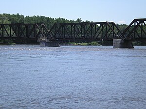
Bordeaux Railway Bridge
Bridge in Montreal/Laval, Quebec
Distance: Approx. 178 meters
Latitude and longitude: 45.548205,-73.699615
The Bordeaux Railway Bridge is a railway bridge on the Canadian Pacific Railway line across the Rivière des Prairies between Ahuntsic-Cartierville, on Montreal Island, and Laval-des-Rapides, Laval, Quebec, Canada. This bridge is used by freight trains of the Canadian Pacific Railway (CPR), the Chemins de Fer Québec-Gatineau (CFQG) and by passenger suburban trains of Exo's Saint-Jerome line. A four-rail gauntlet track is still in use on this bridge because the horizontal structure gauge is not sufficiently wide for a regular double track.
Nouveau-Bordeaux
Neighbourhood in Montreal, Quebec, Canada
Distance: Approx. 1703 meters
Latitude and longitude: 45.546817,-73.677017
Nouveau-Bordeaux (French pronunciation: [nuvo bɔʁdo], lit. 'New Bordeaux') originally known as Bordeaux, is a neighbourhood in north end Montreal, Quebec, Canada located in the borough of Ahuntsic-Cartierville. Nouveau-Bordeaux is bordered on the north by Rivière des Prairies, to the northeast by Ahuntsic, to the southeast by the borough of Saint-Laurent and to the southwest by the neighbourhood of Cartierville. Formerly an independent city, Bordeaux was annexed by the much larger city of Montreal in the year 1910, at the same time as neighboring Ahuntsic.

Bois-de-Boulogne station
Railway station in Montreal, Quebec, Canada
Distance: Approx. 1957 meters
Latitude and longitude: 45.54027778,-73.67722222
Bois-de-Boulogne station is a commuter rail station operated by Exo in Montreal, Quebec, Canada. It is served by the Saint-Jérôme line.

Médéric Martin Bridge
Bridge over the Rivière des Prairies in Quebec, Canada
Distance: Approx. 1495 meters
Latitude and longitude: 45.54019444,-73.71219444
Médéric Martin Bridge is a viaduct-type bridge in Quebec, Canada that spans Rivière des Prairies between Montreal and Laval. It carries 8 lanes of Quebec Autoroute 15, including 1 reserved bus and carpooling lanes. It was named after Médéric Martin, who was a Member of Parliament for St.
Collège Montmorency
Public college in Laval, Quebec
Distance: Approx. 1980 meters
Latitude and longitude: 45.5602,-73.7189
Collège Montmorency is a public college in Chomedey, Laval, Quebec, Canada, near the Montmorency Metro station. As of 2015, there were over 7,000 full-time students enrolled.

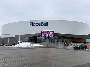
Place Bell
Arena in Laval, Quebec, Canada
Distance: Approx. 1943 meters
Latitude and longitude: 45.5558,-73.7218
Place Bell is a multi-purpose arena in Laval, Quebec, Canada. The complex includes a 10,000-seat main arena, which is the home of the Laval Rocket of the American Hockey League (AHL), and two smaller community ice rinks, one of which has Olympic-size ice. The arena was also home to Les Canadiennes de Montréal for the final season of play in the Canadian Women's Hockey League (CWHL).
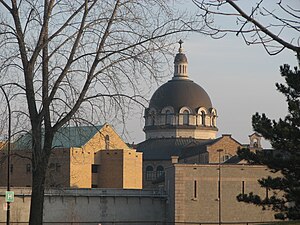
Bordeaux Prison
Prison in Canada
Distance: Approx. 1101 meters
Latitude and longitude: 45.545,-73.686
The Bordeaux Prison (French: Prison de Bordeaux), also known as the Montreal Detention Centre, is a provincial prison in Montreal, Quebec, Canada. It is located at 800 Gouin Boulevard West in the borough of Ahuntsic-Cartierville. The prison was built between 1908 and 1912 by architect Jean-Omer Marchand to replace the aged Pied-du-Courant Prison.
Weather in this IP's area
moderate rain
7 Celsius
4 Celsius
4 Celsius
7 Celsius
1023 hPa
83 %
1023 hPa
1021 hPa
10000 meters
4.12 m/s
160 degree
100 %
06:39:13
16:37:29


