Country:
 Canada
Region:
City:
Latitude and Longitude:
Time Zone:
Postal Code:
IP information under different IP Channel
ip-api
Country
Region
City
ASN
Time Zone
ISP
Blacklist
Proxy
Latitude
Longitude
Postal
Route
IPinfo
Country
Region
City
ASN
Time Zone
ISP
Blacklist
Proxy
Latitude
Longitude
Postal
Route
MaxMind
Country
Region
City
ASN
Time Zone
ISP
Blacklist
Proxy
Latitude
Longitude
Postal
Route
Luminati
Country
CARegion
qc
City
levis
ASN
Time Zone
America/Toronto
ISP
OXIO-ASN-01
Latitude
Longitude
Postal
db-ip
Country
Region
City
ASN
Time Zone
ISP
Blacklist
Proxy
Latitude
Longitude
Postal
Route
ipdata
Country
Region
City
ASN
Time Zone
ISP
Blacklist
Proxy
Latitude
Longitude
Postal
Route
Popular places and events near this IP address

Régiment de la Chaudière
Military unit
Distance: Approx. 655 meters
Latitude and longitude: 46.80361111,-71.18388889
The Régiment de la Chaudière is a Primary Reserve infantry regiment of the Canadian Army. It is part of the 2nd Canadian Division's 35 Canadian Brigade Group and is headquartered at Lévis, Quebec.

Cégep de Lévis
Public college in Lévis, Quebec
Distance: Approx. 2158 meters
Latitude and longitude: 46.81613333,-71.15241667
Cégep de Lévis, formerly known as Cégep de Lévis-Lauzon, is a CEGEP in Lévis, Quebec, Canada.
Lévis Forts
Distance: Approx. 1707 meters
Latitude and longitude: 46.814502,-71.15804
The Lévis Forts were a series of three forts located on the South Shore of the Saint Lawrence River in Lévis, Quebec, Canada. They were at shooting distance of one another which allowed the defense of a wide area without the cost of a continuous defensive wall. The first one was built (1865-1872) by the British Army and the other ones by private businesses (1865-1869).
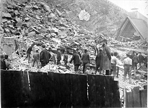
Quebec rockslide
Distance: Approx. 2124 meters
Latitude and longitude: 46.808,-71.203
The Quebec rockslide occurred on September 19, 1889, after a day of heavy rain in Quebec City, Canada. An overhanging piece of slate rock broke off from Cap Diamant and fell 90 metres (300 feet) onto the houses below. The homes of 28 families on Champlain Street were crushed, burying roughly 100 people under 24 metres (80 feet) of broken slate rock.
Cap Diamant
Cape in Quebec, Canada
Distance: Approx. 2050 meters
Latitude and longitude: 46.80916667,-71.20166667
Cap Diamant (English: Cape Diamond) is a cape on an edge of the Promontory of Quebec and on which Quebec City is located, formed by the confluence of a bend in the St. Lawrence River to the south and east, and the much smaller Saint-Charles River to the north. Jacques Cartier, the French explorer who found glittering stones in the high cliff, thought the stones contained diamonds.
CJMD-FM
Radio station in Lévis, Quebec
Distance: Approx. 1556 meters
Latitude and longitude: 46.7921,-71.1837
CJMD-FM is a Canadian radio station, broadcasting a French-language community radio format on the frequency 96.9 FM in Lévis, Quebec. Owned by Radio communautaire de Lévis, the station received CRTC approval on September 4, 2009. The station is a member of the Association des radiodiffuseurs communautaires du Québec.

Marie-Josephte Corriveau
Woman from New France who murdered her second husband (1733–1763)
Distance: Approx. 1802 meters
Latitude and longitude: 46.82097222,-71.17272222
Marie-Josephte Corriveau (1733 at Saint-Vallier, Quebec – (1763-04-18)April 18, 1763 at Quebec City), better known as "la Corriveau", is a well-known figure in Québécois folklore. She lived in New France, and was sentenced to death by a British court martial for the murder of her second husband, was hanged for it and her body hanged in chains. Her story has become a legend in Quebec, and she is the subject of many books and plays.

Habitation de Québec
French colonial settlement
Distance: Approx. 2242 meters
Latitude and longitude: 46.8129,-71.2025
Habitation de Québec was an ensemble of buildings interconnected by Samuel de Champlain when he founded Québec during 1608. The site is located in what is now Vieux-Québec, on the site of present-day Place Royale.It was located near the site of the abandoned First Nations village of Stadacona that Jacques Cartier had visited during 1535. It served as a fort and as dwellings for the new colony in New France.
Les Galeries Chagnon
Shopping mall in Quebec, Canada
Distance: Approx. 983 meters
Latitude and longitude: 46.7966,-71.1711
Les Galeries Chagnon is an enclosed regional shopping mall in Lévis, Quebec, Canada. It has 106 stores and its floor area is 526,734 square feet (48,935.2 m2). According to a 2006 study, the mall was one of six regional or larger malls in the Quebec metropolitan area, but the only one located south of the Saint Lawrence River.
Desjardins, Lévis, Quebec
Borough of Lévis, Quebec, Canada
Distance: Approx. 1004 meters
Latitude and longitude: 46.7959,-71.1764
Desjardins is a borough of the city of Lévis, Quebec. It was created on January 1, 2002. It has three districts, corresponding to former municipalities: Lévis (the territory of the pre-2002 city) Pintendre Saint-Joseph-de-la-Pointe-De Lévy The pre-2002 city of Lévis had already annexed the former municipalities of Lauzon and Saint-David-de-l'Auberivière in 1989.

Lévis station
Railway station in Quebec, Canada
Distance: Approx. 1070 meters
Latitude and longitude: 46.81031944,-71.1871
Lévis station (also known as Gare fluviale de Lévis and as Gare de l'Intercolonial) is a ferry terminal and former railway station in Lévis, Quebec, Canada at 5995, rue Saint-Laurent. It is also served by city buses operated by the Société de transport de Lévis. The Société des traversiers du Québec operates ferry service between this terminal and downtown Quebec City.

Rue du Petit-Champlain
Prominent street in Quebec City, Canada
Distance: Approx. 2239 meters
Latitude and longitude: 46.81096046,-71.20351446
Rue du Petit-Champlain (English: Little Champlain Street) is a street in the Canadian city of Quebec City, Quebec. It is located in the Petit Champlain commercial district, at the foot of Cap Diamant, and contains many boutique shops. Quartier du Petit Champlain is claimed to be the oldest commercial district in North America.
Weather in this IP's area
few clouds
18 Celsius
18 Celsius
15 Celsius
19 Celsius
1017 hPa
83 %
1017 hPa
1005 hPa
10000 meters
20 %
06:26:57
18:50:32