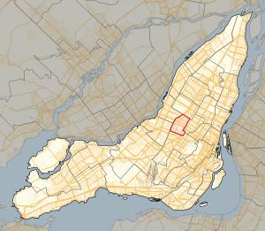
Country:
Region:
City:
Latitude and Longitude:
Time Zone:
Postal Code:
IP information under different IP Channel
ip-api
Country
Region
City
ASN
Time Zone
ISP
Blacklist
Proxy
Latitude
Longitude
Postal
Route
Luminati
Country
Region
qc
City
brossard
ASN
Time Zone
America/Toronto
ISP
OXIO-ASN-01
Latitude
Longitude
Postal
IPinfo
Country
Region
City
ASN
Time Zone
ISP
Blacklist
Proxy
Latitude
Longitude
Postal
Route
db-ip
Country
Region
City
ASN
Time Zone
ISP
Blacklist
Proxy
Latitude
Longitude
Postal
Route
ipdata
Country
Region
City
ASN
Time Zone
ISP
Blacklist
Proxy
Latitude
Longitude
Postal
Route
Popular places and events near this IP address

Jarry Park
Urban park in Montreal, Canada
Distance: Approx. 361 meters
Latitude and longitude: 45.535,-73.6283
Jarry Park is an urban park in the Villeray–Saint-Michel–Parc-Extension borough of Montreal, Quebec, Canada. Jarry Park has total area of 36 hectares. It is considered by the City of Montreal as one of its large parks.

De Castelnau station
Montreal Metro station
Distance: Approx. 355 meters
Latitude and longitude: 45.53527778,-73.62
De Castelnau station is a Montreal Metro station in the Villeray–Saint-Michel–Parc-Extension borough of Montreal, Quebec, Canada. It is operated by the Société de transport de Montréal (STM) and serves the Blue Line. It is located in the Villeray district.
Villeray, Montreal
Neighbourhood in Montreal, Quebec, Canada
Distance: Approx. 497 meters
Latitude and longitude: 45.540143,-73.627882
Villeray is a neighbourhood in Montreal, Quebec, Canada. It is part of the Villeray–Saint-Michel–Parc-Extension borough and is situated in the north-central part of the Island of Montreal.
Little Italy, Montreal
Neighbourhood in Montreal, Quebec, Canada
Distance: Approx. 677 meters
Latitude and longitude: 45.53161111,-73.61902778
Little Italy (French: La Petite-Italie; Italian: Piccola Italia) is a neighbourhood in Montreal, Quebec, Canada. It is centered on Saint Laurent Boulevard between Jean Talon Street and St. Zotique Street in the borough of Rosemont–La Petite-Patrie, south of Villeray and Jarry Park.
Breakglass Studio
Distance: Approx. 400 meters
Latitude and longitude: 45.53444444,-73.62
Breakglass Studios is a Canadian analogue and digital recording studio established in 2005. Co-founded by producer Dave Smith and Jace Lasek, the 5,000-square-foot (460 m2) studio space is located in the Le Plateau-Mont-Royal area of Montreal, Quebec. Since its inception, the studio has had a third partner in James Benjamin.

Laurier-Dorion
Provincial electoral district in Quebec, Canada
Distance: Approx. 358 meters
Latitude and longitude: 45.53333333,-73.625
Laurier-Dorion is a provincial electoral district in the Montreal region of Quebec, Canada that elects members to the National Assembly of Quebec. It consists of the neighbourhoods of Villeray and Park Extension in the city of Montreal. It was created for the 1994 election from parts of Laurier and Dorion electoral districts.

Jarry Park Stadium
Sports venue in Montreal
Distance: Approx. 466 meters
Latitude and longitude: 45.53277778,-73.62694444
Jarry Park Stadium (French: Stade Parc Jarry [stad paʁk ʒaʁi]) is a former baseball stadium, home to the Montreal Expos (now Washington Nationals), from 1969 through 1976, located in Montreal, Quebec, Canada. The Expos were Major League Baseball's first Canadian franchise. It served as a temporary home (for their eight seasons) until Olympic Stadium was made available to the Expos in 1977; its roof was completed a decade later.
Dorion (provincial electoral district)
Provincial electoral district in Quebec, Canada
Distance: Approx. 497 meters
Latitude and longitude: 45.540143,-73.627882
Dorion was a provincial electoral district in the province of Quebec, Canada. It corresponded to the Villeray neighbourhood in Montreal. It was created for the 1966 election from parts of Montréal-Outremont, Montréal–Jeanne-Mance and Montréal-Laurier electoral districts.
Jean Talon Street
Road in Montreal, Canada
Distance: Approx. 817 meters
Latitude and longitude: 45.5387,-73.6142
Jean Talon Street (officially in French: rue Jean-Talon) is one of the longest streets on the Island of Montreal. It runs from Décarie Boulevard in the west through Anjou in the east to Galeries d'Anjou. Jean Talon was the first Intendant of New France.

Parc station (Montreal)
Montreal Metro and railway station
Distance: Approx. 669 meters
Latitude and longitude: 45.5305,-73.6237
Parc station, also known as Park Avenue station and formerly Jean-Talon station (French: Gare Jean-Talon), is a historic railway station building in Montreal, Quebec, Canada. Its western end currently houses the Montreal Metro's Parc station, while businesses occupy the rest of the building. Although the main building no longer serves the railway, the Exo commuter rail Parc station is adjacent to it.

Centre justice et foi
Distance: Approx. 660 meters
Latitude and longitude: 45.538636,-73.632097
Centre justice et foi (English: Centre for Justice and Faith), abbreviated to CJF, is a centre for social analysis in Montreal. It was founded by the Society of Jesus in 1983 and publishes the magazine Relation (French: Revue Relations). It is situated on the corner of Saint Laurent Boulevard and Jarry Street opposite Jarry Park.

Montreal Institute for the Deaf and Mute
Distance: Approx. 235 meters
Latitude and longitude: 45.5355,-73.62154
The Montreal Institute for the Deaf and Mute was a boarding school operated by the Clercs de Saint-Viateur (English: Clerics of St Viator) between 1848 and 1983 in Montreal, Quebec.
Weather in this IP's area
broken clouds
7 Celsius
3 Celsius
6 Celsius
8 Celsius
1008 hPa
79 %
1008 hPa
1000 hPa
10000 meters
8.23 m/s
10.8 m/s
310 degree
75 %
06:44:34
16:32:04

