Country:
Region:
City:
Latitude and Longitude:
Time Zone:
Postal Code:
IP information under different IP Channel
ip-api
Country
Region
City
ASN
Time Zone
ISP
Blacklist
Proxy
Latitude
Longitude
Postal
Route
Luminati
Country
Region
on
City
toronto
ASN
Time Zone
America/Toronto
ISP
OXIO-ASN-01
Latitude
Longitude
Postal
IPinfo
Country
Region
City
ASN
Time Zone
ISP
Blacklist
Proxy
Latitude
Longitude
Postal
Route
db-ip
Country
Region
City
ASN
Time Zone
ISP
Blacklist
Proxy
Latitude
Longitude
Postal
Route
ipdata
Country
Region
City
ASN
Time Zone
ISP
Blacklist
Proxy
Latitude
Longitude
Postal
Route
Popular places and events near this IP address

Don River (Ontario)
River in Canada
Distance: Approx. 867 meters
Latitude and longitude: 43.65111111,-79.3475
The Don River is a watercourse in southern Ontario that empties into Lake Ontario, at Toronto Harbour. Its mouth was just east of the street grid of the town of York, Upper Canada, the municipality that evolved into Toronto, Ontario. The Don is one of the major watercourses draining Toronto (along with the Humber, and Rouge Rivers) that have headwaters in the Oak Ridges Moraine.

Leslieville
Neighbourhood in Toronto, Ontario, Canada
Distance: Approx. 866 meters
Latitude and longitude: 43.661927,-79.332039
Leslieville is a neighbourhood in Toronto, Ontario, Canada, situated east of the Don River. It is bounded by the Canadian National railway line and Gerrard Street to the north, McGee Street to the west, Eastern Avenue to south, and Coxwell Avenue to the east.
Old Eastern Avenue Bridge
Bridge
Distance: Approx. 956 meters
Latitude and longitude: 43.655577,-79.351762
The Old Eastern Avenue Bridge (also known erroneously as the King Street Bridge) consists of two bridges spanning the Don River in Toronto, Ontario, Canada. The north bridge or Gas Line Bridge is a concrete arch bridge built for Consumer's Gas Company and is used by Enbridge Gas to carry a major gas main. The southern Howe truss bridge, similar to Queen Street Viaduct and Sir Isaac Brock Bridge, previously carried traffic on Eastern Avenue but is currently unused.

Broadview Hotel (Toronto)
Canadian hotel
Distance: Approx. 851 meters
Latitude and longitude: 43.658993,-79.350075
The Broadview Hotel is a 58 room boutique hotel in Toronto, Ontario, Canada. It is located at the intersection of Broadview Avenue and Queen Street East in Toronto's Riverside neighbourhood. Built in 1893, the building was originally a hall with retail and office space and later converted into a hotel.
Pinewood Toronto Studios
Filming location
Distance: Approx. 824 meters
Latitude and longitude: 43.64942778,-79.34193889
Pinewood Toronto Studios (formerly known as Filmport) is a major film and television studio complex in Toronto, Ontario, Canada and is the largest of its kind in Canada. It is the first in Toronto capable of accommodating the production of large-scale films. The studio is named for the British Pinewood Studios Group.
Ralph Thornton Community Centre
Building in Toronto, Canada
Distance: Approx. 652 meters
Latitude and longitude: 43.659174,-79.347333
The Ralph Thornton Community Centre is a community centre that forms the centre of the Leslieville/South Riverdale neighbourhood of Toronto, Canada. The neoclassical heritage structure was originally built by the federal government to house Postal Station G. Designed by one of Toronto's most noted architects E.J. Lennox, it opened in 1913. In 1979 it was leased to the city and converted into a community centre.

The Opera House (Toronto)
Music venue in Toronto, Canada
Distance: Approx. 748 meters
Latitude and longitude: 43.658949,-79.348752
The Opera House is a music venue in Toronto, Ontario, Canada. It is one of the city's most historic performing venues, opening in 1909. It has also been a cinema and a live theatre venue.

De Grassi Street
Street in Toronto, Ontario, Canada
Distance: Approx. 950 meters
Latitude and longitude: 43.663432,-79.347253
De Grassi Street is a side street located in Toronto, Ontario, Canada. It was named after Captain Filippo "Philip" De Grassi, an Italian-born soldier who immigrated to Canada with his family in 1831 and settled in York, Upper Canada. He later became a member of the Family Compact.

Joy Theatre
Distance: Approx. 762 meters
Latitude and longitude: 43.6624,-79.33476
The Joy Theatre (formerly the Rex Theatre) was a small cinema on Toronto's Queen Street East. When built, during World War I the theatre had just 381 seats. In 1941 it was renovated, adding air conditioning, boosting the number of seats to 427, and changing its name from Rex Theatre to Joy Theatre.

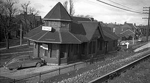
Riverdale station (Toronto)
Railway station in Toronto, Ontario, Canada
Distance: Approx. 674 meters
Latitude and longitude: 43.66083333,-79.34611111
Riverdale Railway Station was located on De Grassi Street just north of Queen Street East in Toronto, Ontario, Canada. Constructed by the Grand Trunk Railway (GTR) in 1896 as "Queen East Station", on what is now the Lakeshore East line, the station was renamed "Riverdale Station" in 1907. The Canadian National Railway (CNR) took over the station in 1923, when they absorbed the Grand Trunk Railway.
East Harbour Transit Hub
Planned transit hub in Toronto, Canada
Distance: Approx. 637 meters
Latitude and longitude: 43.6551,-79.3476
East Harbour Transit Hub is a combined commuter and rapid transit station under construction in Toronto, Ontario, Canada. For GO Transit, it will be an infill station on the Lakeshore East line between the Union Station and Danforth stations. The transit hub will also serve GO trains for the Stouffville line, as well as the Ontario Line, a light metro line under construction.
White Lily Diner
Restaurant in Toronto, Ontario, Canada
Distance: Approx. 926 meters
Latitude and longitude: 43.65869444,-79.35116667
White Lily Diner is a restaurant in the Riverdale neighbourhood of Toronto, Ontario, Canada. The restaurant is known for their all-day diner offerings, as well as rotating daily flavour varieties of doughnuts prepared by the restaurant's pastry chef Rachelle Cornish. The owners cited the diner concept of U.S. restaurant chain Waffle House as an inspiration for White Lily Diner's own model and some menu items, such as the patty melt.
Weather in this IP's area
overcast clouds
12 Celsius
11 Celsius
11 Celsius
13 Celsius
1015 hPa
62 %
1015 hPa
1006 hPa
10000 meters
8.75 m/s
13.38 m/s
280 degree
100 %
07:02:58
16:59:23


