Country:
 Canada
Region:
City:
Latitude and Longitude:
Time Zone:
Postal Code:
IP information under different IP Channel
ip-api
Country
Region
City
ASN
Time Zone
ISP
Blacklist
Proxy
Latitude
Longitude
Postal
Route
IPinfo
Country
Region
City
ASN
Time Zone
ISP
Blacklist
Proxy
Latitude
Longitude
Postal
Route
MaxMind
Country
Region
City
ASN
Time Zone
ISP
Blacklist
Proxy
Latitude
Longitude
Postal
Route
Luminati
Country
CARegion
on
City
oshawa
ASN
Time Zone
America/Toronto
ISP
OXIO-ASN-01
Latitude
Longitude
Postal
db-ip
Country
Region
City
ASN
Time Zone
ISP
Blacklist
Proxy
Latitude
Longitude
Postal
Route
ipdata
Country
Region
City
ASN
Time Zone
ISP
Blacklist
Proxy
Latitude
Longitude
Postal
Route
Popular places and events near this IP address
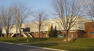
Oshawa Civic Auditorium
Former indoor arena
Distance: Approx. 1174 meters
Latitude and longitude: 43.887795,-78.890998
The Oshawa Civic Auditorium was an indoor arena in Oshawa, Ontario, Canada. It operated from 1964 to 2006, and was primarily used as an ice hockey venue for the Oshawa Generals. The auditorium was built as a replacement to the Hambly Arena, which burned down in 1953.

Oshawa GO Station
Railway station in Oshawa, Ontario, Canada
Distance: Approx. 1623 meters
Latitude and longitude: 43.87055556,-78.88555556
Durham College Oshawa GO station is a station for commuter rail, passenger rail and regional bus services in Oshawa, Ontario, Canada. It is the terminal station for the Lakeshore East line of GO Transit and serves Via Rail's Corridor service, which travels from Toronto to both Ottawa and Montreal. The bus terminal is served by bus routes of GO Transit and Durham Region Transit.
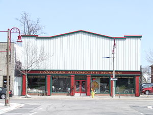
Canadian Automotive Museum
Automobile museum in Oshawa, Ontario
Distance: Approx. 1727 meters
Latitude and longitude: 43.89486111,-78.86216667
The Canadian Automotive Museum is an automobile museum located in Oshawa, Ontario, Canada. The museum features many Canadian-made cars as the automobile industry, specifically the Canadian division of the General Motors, known as General Motors Canada, which has always been at the forefront of Oshawa's economy. The museum was founded in 1962 by a group of Oshawa businessmen through the Oshawa Chamber of Commerce.
Hambly Arena
Former indoor ice rink in Ontario, Canada
Distance: Approx. 1655 meters
Latitude and longitude: 43.89777778,-78.87
The Hambly Arena was an indoor ice rink in Oshawa, Ontario, also known as the Oshawa Arena. It operated from 1930 to 1953, and was primarily used as an ice hockey venue for the Oshawa Generals. The Hambly Arena was built as a replacement to the wooden Bradley Arena, which burned down in 1928.
RCAF Station Oshawa
Distance: Approx. 1814 meters
Latitude and longitude: 43.88333333,-78.9
RCAF Station Oshawa was a training station of the British Commonwealth Air Training Plan (BCATP) during World War II located near Oshawa, Ontario, Canada. The No. 20 Elementary Flying Training School (EFTS) was located in Oshawa from June 1941 to December 1944.

Oshawa Centre
Shopping mall
Distance: Approx. 695 meters
Latitude and longitude: 43.88998,-78.87935
Oshawa Centre is a two-storey shopping mall located in the city of Oshawa, Ontario, Canada. Located at King Street and Stevenson Road, it is the largest mall in Durham Region and the largest in Ontario east of Toronto with over 230 retail stores and public services. Its Executive Office complex includes the Ministry of Health of Ontario.
Oshawa Bus Terminal
Distance: Approx. 1814 meters
Latitude and longitude: 43.89777778,-78.86555556
Oshawa Bus Terminal was a bus terminal located at 47 Bond Street West in Oshawa, Ontario, Canada. The building is owned by the City of Oshawa and incorporates a multi-storey municipal parking lot; it no longer serves buses. City Council has adopted, in principle, the Downtown Action Plan, July 2005, which recommended that the bus terminal functions should be relocated from this priority development site.
Oshawa Metal
Distance: Approx. 1520 meters
Latitude and longitude: 43.87036389,-78.87488333
Oshawa Metal or Oshawa Metal Centre is a General Motors of Canada facility in Oshawa, Ontario. Built in 1986 to supply metal for Chevrolet Lumina and Buick Regal made in Oshawa, the plant now makes steel used at the Oshawa Car Assembly plant and other GM customers. It is GM's only metal facility in Canada located close to an assembly plant.

Oshawa Public Library
Canadian public library system
Distance: Approx. 1576 meters
Latitude and longitude: 43.89492,-78.86507
Oshawa Public Libraries (OPL) is a public library system that serves a population of more than 170,000 people in the City of Oshawa, Ontario, Canada. OPL has 4 branches, each serving its respective region of Oshawa, and sharing its collections in common amongst all the branches within the system. The City of Oshawa is situated on the Lake Ontario shoreline approximately 60 kilometres east of downtown Toronto.

Robert McLaughlin Gallery
Art museum in Ontario, Canada
Distance: Approx. 1589 meters
Latitude and longitude: 43.895412,-78.865689
The Robert McLaughlin Gallery is a public art gallery in Oshawa, Ontario, Canada. It is the largest public art gallery in the Regional Municipality of Durham, of which Oshawa is a part. The gallery houses a significant collection of Canadian contemporary and modern artwork.
Thornton's Corners East GO Station
Proposed railway station in Oshawa, Ontario, Canada
Distance: Approx. 681 meters
Latitude and longitude: 43.8798,-78.8837
Thornton's Corners East GO Station is a planned GO Transit train station to be built by Metrolinx in the community of Oshawa, Ontario, as part of the approved expansion of train service on the Lakeshore East line to Bowmanville. The station would be located along a new single-track spur line connecting the CN rail corridor east of Oshawa GO Station to CP Rail's Belleville Subdivision farther north. The station would be on the west side of Fox Street north of Laval Drive.

St. George's Memorial Church (Oshawa)
Anglican church in Oshawa, Canada
Distance: Approx. 1546 meters
Latitude and longitude: 43.8956926,-78.8672316
St. George's Memorial Church is an Anglican church in Oshawa, Ontario, Canada.
Weather in this IP's area
scattered clouds
18 Celsius
18 Celsius
18 Celsius
20 Celsius
1017 hPa
77 %
1017 hPa
1005 hPa
10000 meters
2.06 m/s
60 degree
40 %
06:58:42
19:20:23