Country:
 Canada
Region:
City:
Latitude and Longitude:
Time Zone:
Postal Code:
IP information under different IP Channel
ip-api
Country
Region
City
ASN
Time Zone
ISP
Blacklist
Proxy
Latitude
Longitude
Postal
Route
IPinfo
Country
Region
City
ASN
Time Zone
ISP
Blacklist
Proxy
Latitude
Longitude
Postal
Route
MaxMind
Country
Region
City
ASN
Time Zone
ISP
Blacklist
Proxy
Latitude
Longitude
Postal
Route
Luminati
Country
CARegion
on
City
ottawa
ASN
Time Zone
America/Toronto
ISP
OXIO-ASN-01
Latitude
Longitude
Postal
db-ip
Country
Region
City
ASN
Time Zone
ISP
Blacklist
Proxy
Latitude
Longitude
Postal
Route
ipdata
Country
Region
City
ASN
Time Zone
ISP
Blacklist
Proxy
Latitude
Longitude
Postal
Route
Popular places and events near this IP address

Ottawa Centre (federal electoral district)
Federal electoral district in Ontario, Canada
Distance: Approx. 417 meters
Latitude and longitude: 45.41666667,-75.7
Ottawa Centre (French: Ottawa-Centre) is an urban federal electoral district in Ontario, Canada, that has been represented in the House of Commons of Canada since 1968. While the riding's boundaries (mainly to the south and west as the north and east borders have remained the Ottawa River and Rideau River, respectively) have changed over the years to account for population changes, the riding has always comprised the central areas of Ottawa, the nation's capital. The House of Commons of Canada meets in the West Block of the Parliament Buildings on Parliament Hill, which is located within this district.

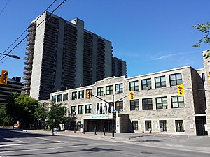
St. Elijah's Housing
Distance: Approx. 90 meters
Latitude and longitude: 45.413165,-75.699969
St. Elijah's Housing is a building in Ottawa, Ontario, Canada. Originally a church, it is currently a block of 40 residential apartments.

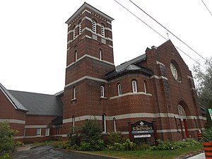
McPhail Memorial Baptist Church
Church in Ontario, Canada
Distance: Approx. 404 meters
Latitude and longitude: 45.412925,-75.70626667
McPhail Memorial Baptist Church is a Baptist church in Ottawa, Ontario, Canada. It is affiliated with Canadian Baptists of Ontario and Quebec.

St Patrick's Basilica (Ottawa)
Church in Ottawa, Ontario
Distance: Approx. 412 meters
Latitude and longitude: 45.416678,-75.700505
St Patrick's Basilica is a Roman Catholic Church in Ottawa, Ontario, Canada. Located at 281 Nepean Street (at the corner of Nepean and Kent) in Downtown Ottawa, it is the oldest church in the city that serves the English-speaking community. The Basilica is one of the regular buildings featured in the Doors Open Ottawa architectural heritage day.
Dey's Arena
Ice rinks linked to history of ice hockey in Canada
Distance: Approx. 386 meters
Latitude and longitude: 45.40971,-75.69953
Dey's Arena, also known as Dey Brothers Rink, Dey's Skating Rink and The Arena, were a series of ice rinks and arenas located in Ottawa, Ontario, that hold importance in the early development of the organized sport of ice hockey in Canada. It was the home arena of the Ottawa Hockey Club, variously known as the Generals, the Silver Seven and the Senators from the 1890s until 1923, although it is known that games were also played at the Rideau Skating Rink in the 1890s and the Aberdeen Pavilion in 1904. The rink and arenas were built by two generations of the Dey family, who were prominent in Ottawa at the time, with a thriving boat works business serving the lumber business.
Rideau Curling Club
Curling facility and organization in Canada
Distance: Approx. 294 meters
Latitude and longitude: 45.412962,-75.704856
The Rideau Curling Club is a curling facility and organization located in Ottawa, Ontario, Canada. Founded in 1888, the Rideau Curling Club maintains a rivalry with the Ottawa Curling Club.

First United Church (Ottawa)
Church in Ontario, Canada
Distance: Approx. 395 meters
Latitude and longitude: 45.412084,-75.696219
First United Church is a United Church of Canada congregation in Ottawa, Ontario, Canada. One of Ottawa's oldest congregations, the church formed in 1846.
Ottawa Centre (provincial electoral district)
Provincial electoral district in Ontario, Canada
Distance: Approx. 417 meters
Latitude and longitude: 45.41666667,-75.7
Ottawa Centre is an urban provincial electoral district in Ontario, Canada that has been represented in the Legislative Assembly of Ontario since 1968. While the riding's boundaries (mainly to the south and west as the north and east borders have remained the Ottawa River and Rideau Canal, respectively) have changed over the years to account for population changes, the riding has always comprised the central areas of Ottawa, the nation's capital.
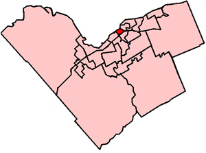
Somerset Ward
Place in Ontario, Canada
Distance: Approx. 417 meters
Latitude and longitude: 45.41666667,-75.7
Somerset (Ward 14) is a city ward in the city of Ottawa, Ontario, Canada. It covers the neighbourhoods of Downtown Ottawa, Centretown, Lebreton Flats and most of Centretown West. It is Ottawa's smallest and most dense ward.

Dundonald Park
Distance: Approx. 19 meters
Latitude and longitude: 45.4129,-75.7013
Dundonald Park is located in the Centretown neighbourhood of Ottawa, Ontario, Canada. It occupies a city block, with Somerset Street West to the north, Bay Street to the west, MacLaren Street to the south, and Lyon Street to the east. It was named after Douglas Cochrane, 12th Earl of Dundonald, who was the last British officer to command the Canadian militia.
Bronson Centre
Distance: Approx. 419 meters
Latitude and longitude: 45.41361111,-75.70638889
The Bronson Centre is a community facility in Ottawa, Ontario, Canada, which provides office and meeting facilities for non-profit organizations. It is located at 211 Bronson Avenue, on the western edge of the city's downtown core. The building was the original site of Immaculata High School, which was originally constructed in 1928 and expanded several times until the school relocated in 1994.
St. Barnabas, Apostle and Martyr Anglican Church
Church in Ottawa, Ontario
Distance: Approx. 324 meters
Latitude and longitude: 45.41224,-75.6971
St. Barnabas, Apostle and Martyr Anglican Church is an Anglican church in the Anglo-Catholic tradition at 70 James Street (at Kent Street) in Ottawa, Ontario, Canada.
Weather in this IP's area
broken clouds
20 Celsius
20 Celsius
18 Celsius
21 Celsius
1017 hPa
84 %
1017 hPa
1008 hPa
10000 meters
75 %
06:45:31
19:08:10