Country:
Region:
City:
Latitude and Longitude:
Time Zone:
Postal Code:
IP information under different IP Channel
ip-api
Country
Region
City
ASN
Time Zone
ISP
Blacklist
Proxy
Latitude
Longitude
Postal
Route
Luminati
Country
Region
on
City
toronto
ASN
Time Zone
America/Toronto
ISP
OXIO-ASN-01
Latitude
Longitude
Postal
IPinfo
Country
Region
City
ASN
Time Zone
ISP
Blacklist
Proxy
Latitude
Longitude
Postal
Route
db-ip
Country
Region
City
ASN
Time Zone
ISP
Blacklist
Proxy
Latitude
Longitude
Postal
Route
ipdata
Country
Region
City
ASN
Time Zone
ISP
Blacklist
Proxy
Latitude
Longitude
Postal
Route
Popular places and events near this IP address

University of Toronto Schools
Independent laboratory school in Toronto, Ontario, Canada
Distance: Approx. 306 meters
Latitude and longitude: 43.66666667,-79.40222222
University of Toronto Schools (UTS) is an independent secondary day school affiliated with the University of Toronto in Toronto, Ontario, Canada. The school follows a specialized academic curriculum, and admission is determined by a written examination and Multiple Mini-Interviews.

The Annex
Neighbourhood in Toronto, Ontario, Canada
Distance: Approx. 189 meters
Latitude and longitude: 43.67,-79.404
The Annex is a neighbourhood in Downtown Toronto, Ontario, Canada. The traditional boundaries of the neighbourhood are north to Dupont Street, south to Bloor Street, west to Bathurst Street and east to Avenue Road. The City of Toronto recognizes a broader neighbourhood definition that includes the adjacent Seaton Village and Yorkville areas.

Bata Shoe Museum
Footwear museum in Toronto, Ontario, Canada
Distance: Approx. 272 meters
Latitude and longitude: 43.66722222,-79.40027778
The Bata Shoe Museum (BSM) is a museum of footwear and calceology in Toronto, Ontario, Canada. The museum's building is situated near the northwest of the University of Toronto's St. George campus, in downtown Toronto.
Rochdale College
Alternative education project in Toronto
Distance: Approx. 284 meters
Latitude and longitude: 43.66694444,-79.40083333
Rochdale College was an experiment in student-run alternative education and co-operative living in Toronto, Canada from 1968 to 1975. It provided space for 840 residents in a co-operative living space. It was also an informal, noncredited free university where students and teachers would live together and share knowledge.

Tartu College
Student residence, and Estonian culture centre in Ontario
Distance: Approx. 249 meters
Latitude and longitude: 43.66722222,-79.4025
Tartu College is a not for profit student residence on the north side of Bloor Street West, just east of Madison Avenue, in Toronto, Ontario, Canada. Most of its residents are students of the University of Toronto. Tartu College was built in 1970, two years after its sister building, the David A. Croll Apartments (originally Rochdale College), was built a block away on the opposite side of the street in 1968.

Spadina station
Toronto subway station
Distance: Approx. 295 meters
Latitude and longitude: 43.66722222,-79.40388889
Spadina is a subway station on Line 1 Yonge–University and Line 2 Bloor–Danforth in Toronto, Ontario, Canada. It is located on Spadina Road, north of Bloor Street West. It is one of only three stations open overnight, along with Queens Quay station and Union station.

St. George station
Toronto subway station
Distance: Approx. 224 meters
Latitude and longitude: 43.66805556,-79.39972222
St. George is a station on Line 1 Yonge–University and Line 2 Bloor–Danforth of the Toronto subway. It is located north of Bloor Street West between St.
Bloor Street United Church
Church in Ontario, Canada
Distance: Approx. 229 meters
Latitude and longitude: 43.667348,-79.401965
Bloor Street United Church is a United Church of Canada church in Toronto, Ontario, Canada. It is located on Bloor Street West in the downtown core at the northwest corner of the intersection with Huron Street. It is just north of the University of Toronto, and between the Spadina and St.

First Church of Christ, Scientist (Toronto)
Distance: Approx. 87 meters
Latitude and longitude: 43.670029,-79.40116
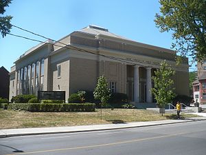
The First Church of Christ, Scientist is the oldest Christian Science congregation in Toronto, Ontario, Canada. It is located at 196 St. George St.
University Women's Club of Toronto
Canadian organization
Distance: Approx. 296 meters
Latitude and longitude: 43.66707,-79.400028
The University Women's Club of Toronto is a Canadian organization that was founded in 1903 to promote women's education. Its parent organization is Canadian Federation of University Women.
York Club
Private club in Toronto, Ontario, Canada
Distance: Approx. 262 meters
Latitude and longitude: 43.66777778,-79.39944444
The York Club is a private members' club that was incorporated on November 22, 1909. It is located at 135 St. George Street in The Annex neighbourhood of central Toronto, Ontario, close to the University of Toronto's main campus.

City Shul
Reform synagogue in Toronto, Canada
Distance: Approx. 242 meters
Latitude and longitude: 43.66723,-79.401959
City Shul is a Reform synagogue in downtown Toronto, founded in October 2012 and led by Rabbi Elyse Goldstein. Until September 2017, the congregation met at the Wolfond Centre for Jewish Campus Life, near the St George campus of the University of Toronto. From 2017 to 2022, it was located in the same building as Bloor Street United Church.
Weather in this IP's area
overcast clouds
12 Celsius
10 Celsius
11 Celsius
12 Celsius
1015 hPa
62 %
1015 hPa
1001 hPa
10000 meters
11.32 m/s
15.43 m/s
300 degree
100 %
07:03:15
16:59:36

