Country:
 Canada
Region:
City:
Latitude and Longitude:
Time Zone:
Postal Code:
IP information under different IP Channel
ip-api
Country
Region
City
ASN
Time Zone
ISP
Blacklist
Proxy
Latitude
Longitude
Postal
Route
IPinfo
Country
Region
City
ASN
Time Zone
ISP
Blacklist
Proxy
Latitude
Longitude
Postal
Route
MaxMind
Country
Region
City
ASN
Time Zone
ISP
Blacklist
Proxy
Latitude
Longitude
Postal
Route
Luminati
Country
CARegion
on
City
toronto
ASN
Time Zone
America/Toronto
ISP
OXIO-ASN-01
Latitude
Longitude
Postal
db-ip
Country
Region
City
ASN
Time Zone
ISP
Blacklist
Proxy
Latitude
Longitude
Postal
Route
ipdata
Country
Region
City
ASN
Time Zone
ISP
Blacklist
Proxy
Latitude
Longitude
Postal
Route
Popular places and events near this IP address

Parkdale, Toronto
Neighbourhood in Toronto, Ontario, Canada
Distance: Approx. 322 meters
Latitude and longitude: 43.64,-79.437
Parkdale is a neighbourhood and former village in Toronto, Ontario, Canada, west of downtown. The neighbourhood is bounded on the west by Roncesvalles Avenue; on the north by the CP Rail line where it crosses Queen Street and Dundas Street; on the east by Dufferin Street from Queen Street south; and on the south by Lake Ontario. The original village incorporated an area north of Queen Street, east of Roncesvalles from Fermanagh east to the main rail lines, today known as part of the Roncesvalles neighbourhood.
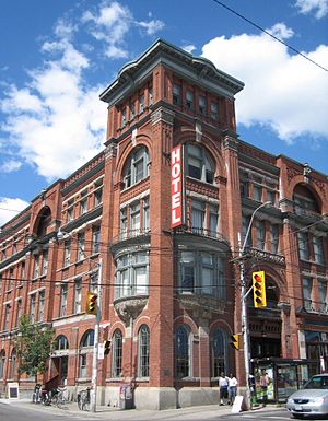
Gladstone Hotel (Toronto)
Hotel in Toronto, Ontario
Distance: Approx. 568 meters
Latitude and longitude: 43.642683,-79.427
Gladstone House (formerly the Gladstone Hotel) is a boutique hotel at 1214 Queen Street West in the Parkdale area of Toronto, Ontario, Canada. Since renovations in the early 2000s, the hotel has become an arts hub in the West Queen West neighbourhood of Toronto. The hotel's restaurant and bar is located on the main floor and is known as Gladstone House Bistro + Bar.
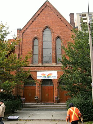
St. John's Cathedral (Toronto)
Church in Ontario, Canada
Distance: Approx. 46 meters
Latitude and longitude: 43.63972222,-79.43258333
St. John's Cathedral Polish Catholic Church in the Parkdale area of Toronto, Ontario, is the seat of the Polish National Catholic Church's (PNCC) diocese in Canada.
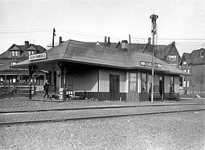
South Parkdale station
Railway station in Toronto, Ontario, Canada
Distance: Approx. 713 meters
Latitude and longitude: 43.63361111,-79.43361111
The South Parkdale railway station was a passenger rail station on the Grand Trunk Railway in Toronto, Ontario, Canada. It was located at Jameson Avenue and Springhurst Avenue in the former village of Parkdale. It was demolished in 1911 as part of a grade separation engineering project.

Parkdale Collegiate Institute
High school in Toronto, Ontario, Canada
Distance: Approx. 262 meters
Latitude and longitude: 43.63964722,-79.43621667
Founded in 1888, Parkdale Collegiate Institute is a public high school located on Jameson Avenue in Parkdale, Toronto, Ontario, Canada. It is located in the heart of what is considered 'Little Tibet', which is the home of the largest concentration of Tibetans in the city.
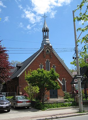
Epiphany and St. Mark, Parkdale
Church in Ontario, Canada
Distance: Approx. 88 meters
Latitude and longitude: 43.6407,-79.4325
The Church of the Epiphany and St. Mark, Parkdale, is a small inclusive parish of the Anglican Church of Canada located in the Parkdale area of Toronto, Ontario. The church was founded upon the 1983 amalgamation of The Church of the Epiphany and The Church of St.

St. Philip's Seminary
Distance: Approx. 270 meters
Latitude and longitude: 43.6378,-79.43441
Saint Philip's Seminary is an apostolate of the Toronto Oratory, a Catholic society of apostolic life. It has been authorized to grant degrees by the province of Ontario. It accepts students for the priesthood who are sponsored by their diocese or by their religious order.
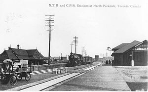
Parkdale station (Toronto)
Railway station in Toronto, Ontario, Canada
Distance: Approx. 493 meters
Latitude and longitude: 43.64194444,-79.4275
Parkdale railway station or North Parkdale railway station as it was also known was a passenger train station in Toronto, Ontario, Canada. The station served the Parkdale village on the then-outskirts of Toronto. The station served trains on the Northern Railway of Canada and Credit Valley Railway, later the Canadian Pacific Railway, railways.
Grand National Rink
Former outdoor skating rink in Toronto, Ontario, Canada
Distance: Approx. 724 meters
Latitude and longitude: 43.64643483,-79.43428072
The Grand National Rink was an outdoor skating rink located in the Brockton Village neighbourhood of Toronto, Ontario, Canada from 1896 to 1902. At the time, it was the largest open-air rink in the city. Its location is now the site of the McCormick Playground Arena at McCormick Park in the Little Portugal neighbourhood.
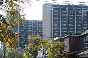
West Lodge Apartments
Apartment complex in Toronto
Distance: Approx. 634 meters
Latitude and longitude: 43.64526,-79.43601
West Lodge Apartments, also known simply as West Lodge, is a 720 unit apartment complex located at 103 and 105 West Lodge Avenue in Parkdale, Toronto. The complex consists of two curved 18 story towers joined at the base by a 5-story segment which includes a convenience store on the second floor. The complex was built in 1964 and by the mid 1970s had already become notorious as the source of numerous building code violations, and for its general state of disrepair.
King–Liberty GO Station
Planned commuter train station in Toronto
Distance: Approx. 740 meters
Latitude and longitude: 43.6409,-79.4239
King–Liberty GO Station (also referred to as Liberty Village) is a planned regional train station in Toronto, Ontario, Canada. It will be an infill station on the Kitchener line of GO Transit located between Union Station and Bloor GO Station. The station is one of five GO stations to be built as part of the SmartTrack Stations Program to adapt regional commuter service for urban public transit.

BB's (restaurant)
Filipino restaurant in Toronto, Ontario, Canada
Distance: Approx. 232 meters
Latitude and longitude: 43.64202778,-79.43236111
BB's is a Filipino restaurant in Toronto, Ontario, Canada. The restaurant's name stands for Bahay ni Bella (translation: Bella's House), referencing the owner, Justin Bella's, last name. The restaurant originally opened up as BB's Diner in Toronto's Kensington Market neighbourhood located downtown.
Weather in this IP's area
clear sky
20 Celsius
20 Celsius
18 Celsius
21 Celsius
1017 hPa
81 %
1017 hPa
1006 hPa
10000 meters
4.12 m/s
50 degree
07:01:00
19:22:32