Country:
Region:
City:
Latitude and Longitude:
Time Zone:
Postal Code:
IP information under different IP Channel
ip-api
Country
Region
City
ASN
Time Zone
ISP
Blacklist
Proxy
Latitude
Longitude
Postal
Route
Luminati
Country
Region
on
City
toronto
ASN
Time Zone
America/Toronto
ISP
OXIO-ASN-01
Latitude
Longitude
Postal
IPinfo
Country
Region
City
ASN
Time Zone
ISP
Blacklist
Proxy
Latitude
Longitude
Postal
Route
db-ip
Country
Region
City
ASN
Time Zone
ISP
Blacklist
Proxy
Latitude
Longitude
Postal
Route
ipdata
Country
Region
City
ASN
Time Zone
ISP
Blacklist
Proxy
Latitude
Longitude
Postal
Route
Popular places and events near this IP address

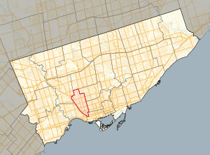
Davenport (federal electoral district)
Federal electoral district in Ontario, Canada
Distance: Approx. 696 meters
Latitude and longitude: 43.67,-79.44
Davenport is a federal electoral district in Toronto, Ontario, Canada, that has been represented in the House of Commons of Canada since 1935.

Dufferin station
Toronto subway station
Distance: Approx. 599 meters
Latitude and longitude: 43.66,-79.43555556
Dufferin is a subway station on Line 2 Bloor–Danforth of the Toronto subway in Toronto, Ontario, Canada. It is located at Dufferin Street just north of Bloor Street West. It opened in 1966 as part of the original segment of the subway line.

Dovercourt Park
Neighbourhood in Toronto, Ontario, Canada
Distance: Approx. 188 meters
Latitude and longitude: 43.665,-79.432
Dovercourt Park or Dovercourt Village is a neighbourhood in Toronto, Ontario, Canada situated north of Bloor Street between Christie Street to the east, the CPR railway lines to the north, and Dufferin Street to the west.

Bloor Collegiate Institute
High school in Toronto, Ontario, Canada
Distance: Approx. 703 meters
Latitude and longitude: 43.659292,-79.436994
Bloor Collegiate Institute is a public secondary school in Toronto, Ontario, Canada. It is located at the intersection of Bloor Street and Dufferin Street, in the Dufferin Grove neighbourhood. The school was originally part of the Toronto Board of Education that was merged into the Toronto District School Board.

Galleria Shopping Centre (Toronto)
Shopping mall in Ontario, Canada
Distance: Approx. 667 meters
Latitude and longitude: 43.6675,-79.442
The Galleria Shopping Centre (more commonly known as Galleria Mall) is a shopping centre in Toronto, Ontario, Canada. It is located at the southwest corner of the intersection of Dufferin and Dupont Streets. The mall is in the process of being redeveloped into a mixed-use development.

Davenport (provincial electoral district)
Provincial electoral district in Ontario, Canada
Distance: Approx. 696 meters
Latitude and longitude: 43.67,-79.44
Davenport is a provincial riding in Toronto, Ontario, Canada. It elects one member to the Legislative Assembly of Ontario. It was created in 1999 from parts of Oakwood, Dovercourt, Parkdale, High Park—Swansea and a small part of York South.

Canadian Aeroplanes
Distance: Approx. 647 meters
Latitude and longitude: 43.66781,-79.441552
Canadian Aeroplanes Ltd. was an aircraft manufacturing company located in Toronto, Ontario, Canada that built aircraft for the Royal Flying Corps Canada during the First World War. Formed on December 15, 1916, when the Imperial Munitions Board bought the Curtiss (Canada) aircraft operation in Toronto (opened in 1916 as Toronto Curtiss Aeroplanes) at a 6-acre facility at 1244 Dufferin Street south of Dupont Avenue in April 1917.

Wallace Emerson
Neighbourhood in Toronto, Ontario, Canada
Distance: Approx. 597 meters
Latitude and longitude: 43.663,-79.441
Wallace Emerson is a neighbourhood in Toronto, Ontario, Canada situated north of Bloor Street between Dufferin Street to the east, the CPR railway lines to the north and the CPR railway lines to the west. The neighbourhood derives its name from the intersection of Wallace Avenue and Emerson Avenue near the centre of the community.

Bloor/Gladstone Library
Distance: Approx. 600 meters
Latitude and longitude: 43.659913,-79.434017
The Bloor/Gladstone Library is a branch of Toronto Public Library, located at 1101 Bloor Street West, Toronto, Ontario.

The Monkey's Paw (bookstore)
Distance: Approx. 571 meters
Latitude and longitude: 43.6603,-79.4327
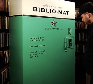
The Monkey's Paw is an independent used bookstore in Toronto, Ontario, Canada known for its eclectic, arcane, and absurd books, and for the Biblio-Mat, a random book vending machine. Owner Stephen Fowler founded The Monkey's Paw in 2006, four years after he moved to Toronto from San Francisco, where he worked in numerous bookstores. Fowler opened The Monkey's Paw in order to support his family with another income source.
Saint Michael the Archangel Serbian Orthodox Church (Toronto)
Church in Toronto, Ontario
Distance: Approx. 605 meters
Latitude and longitude: 43.661868,-79.428467
Saint Michael the Archangel Serbian Eastern Orthodox Church (Serbian: Српска православна црква Светог Архангела Михаила) in Toronto, Ontario, Canada is a Serbian Eastern Orthodox church which is not a member of the Serbian Orthodox Church due to a tumultuous history. In 2008, the church was showcased in the annual Doors Open Toronto event.

Paradise Theatre (Toronto)
Cinema in Ontario, Canada
Distance: Approx. 559 meters
Latitude and longitude: 43.661028,-79.430649
The Paradise Theatre is a movie theatre located at 1006 Bloor Street West in the Bloorcourt Village neighbourhood of Toronto, Ontario, Canada. It first opened in 1937, closed in 2006, and then was to be turned into a pharmacy. However, it was restored and re-opened on December 5, 2019.
Weather in this IP's area
overcast clouds
12 Celsius
11 Celsius
11 Celsius
13 Celsius
1015 hPa
62 %
1015 hPa
1002 hPa
10000 meters
10.8 m/s
15.95 m/s
290 degree
100 %
07:03:22
16:59:45
