Country:
 Canada
Region:
City:
Latitude and Longitude:
Time Zone:
Postal Code:
IP information under different IP Channel
ip-api
Country
Region
City
ASN
Time Zone
ISP
Blacklist
Proxy
Latitude
Longitude
Postal
Route
IPinfo
Country
Region
City
ASN
Time Zone
ISP
Blacklist
Proxy
Latitude
Longitude
Postal
Route
MaxMind
Country
Region
City
ASN
Time Zone
ISP
Blacklist
Proxy
Latitude
Longitude
Postal
Route
Luminati
Country
CARegion
on
City
scarborough
ASN
Time Zone
America/Toronto
ISP
OXIO-ASN-01
Latitude
Longitude
Postal
db-ip
Country
Region
City
ASN
Time Zone
ISP
Blacklist
Proxy
Latitude
Longitude
Postal
Route
ipdata
Country
Region
City
ASN
Time Zone
ISP
Blacklist
Proxy
Latitude
Longitude
Postal
Route
Popular places and events near this IP address

Agincourt, Toronto
Neighbourhood in Toronto, Ontario, Canada
Distance: Approx. 1910 meters
Latitude and longitude: 43.7925,-79.28388889
Agincourt () is a neighbourhood and former village in Toronto, Ontario, Canada. Agincourt is located in northeast Toronto, along Sheppard Avenue between Kennedy and Markham Roads (north-south includes lands between Highway 401 and Finch Avenue). Before the creation of the "megacity" of Toronto in 1998, the area was part of Scarborough.

Scarborough—Agincourt (federal electoral district)
Federal electoral district in Ontario, Canada
Distance: Approx. 1761 meters
Latitude and longitude: 43.796,-79.31
Scarborough—Agincourt is a federal electoral district in Toronto, Ontario, Canada that has been represented in the House of Commons of Canada since 1988. It covers the area of the City of Toronto bounded by Steeles Avenue East to the north, Highway 401 to the south, Victoria Park Avenue to the west, and Midland Avenue to the east.

Agincourt GO Station
GO Transit railway station in Ontario, Canada
Distance: Approx. 1502 meters
Latitude and longitude: 43.78611111,-79.28444444
Agincourt GO Station is a GO Transit railway station in Toronto, Ontario, Canada. The Stouffville line station serves the Agincourt neighbourhood of the former suburb of Scarborough.
Thamil Isai Kalaamanram
Canadian Carnatic music organization
Distance: Approx. 1841 meters
Latitude and longitude: 43.7815,-79.279
Thamil Isai Kalaamanram (Tamil: தமிழ் இசை கலாமன்றம்) (TIKM) is a non-profit organization dedicated to promoting carnatic music and bharathanatyam dance in Ontario, Canada, headquartered in Toronto. Founded in 1992, this Toronto-based organization has grown to become the widely accepted conservatory of South Indian music and dance, servicing over 160 classical music teachers in Canada.

Tam O'Shanter-Sullivan
Neighbourhood in Toronto, Ontario, Canada
Distance: Approx. 753 meters
Latitude and longitude: 43.78805556,-79.30138889
Tam O'Shanter-Sullivan is a neighbourhood in the east end of the city of Toronto, Ontario, Canada, in the district of Scarborough. The neighbourhood is bordered by Huntingwood Drive to the North, Kennedy Road to the East, Highway 401 to the South and Victoria Park (and Pharmacy Ave) to the West. The neighbourhood, which includes the Tam O'Shanter (east of Warden) and Sullivan (west of Warden) communities, takes its name from Tam O’Shanter Golf Course and O'Sullivan's Corners.

Sir John A. Macdonald Collegiate Institute
Public high school in Toronto, Ontario, Canada
Distance: Approx. 1869 meters
Latitude and longitude: 43.786858,-79.323848
Sir John A. Macdonald Collegiate Institute is a secondary school in Toronto, Ontario, Canada. It is located in the L'Amoreaux neighbourhood of the former suburb of Scarborough. It is operated by the Toronto District School Board and previously by the Scarborough Board of Education.

Johnny's Hamburgers
Burger joint in Scarborough, Toronto
Distance: Approx. 1788 meters
Latitude and longitude: 43.77489,-79.322298
Johnny's Hamburgers is an eatery located in Scarborough, Toronto, at Victoria Park Avenue and Sheppard Avenue. It was established in 1967. It serves hamburgers, French fries, and other fast-food items, and is popular with locals.
Scarborough—Agincourt (provincial electoral district)
Provincial electoral district in Ontario, Canada
Distance: Approx. 1761 meters
Latitude and longitude: 43.796,-79.31
Scarborough—Agincourt is a provincial electoral district in Ontario, Canada that has been represented in the Legislative Assembly of Ontario since 1987. The riding covers the northwest of the Scarborough part of Toronto. It is bounded on the west by Victoria Park Avenue, on the north by the Toronto city limits (Steeles Avenue East), on the east by Midland Avenue, and on the south by Highway 401.
Agincourt Mall
Shopping mall
Distance: Approx. 901 meters
Latitude and longitude: 43.7851,-79.292
Agincourt Mall is a shopping mall in Toronto, Ontario, Canada. It is located at the northwest corner of Kennedy Road and Sheppard Avenue, in the Tam O'Shanter – Sullivan neighbourhood of northeastern Toronto. It is named for the adjacent historic village and current Toronto neighbourhood of Agincourt.
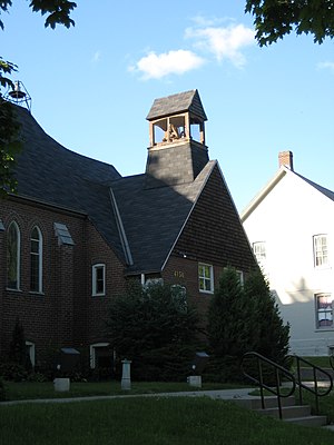
Knox Presbyterian Church (Agincourt)
Church in Ontario, Canada
Distance: Approx. 1704 meters
Latitude and longitude: 43.7852,-79.2814
Knox Presbyterian Church is located at 4156 Sheppard Avenue East in the Agincourt neighbourhood of Toronto, Ontario, Canada. It was formed by former members of the "Historic" Knox Presbyterian Church (now Knox United Church) after that Presbyterian congregation voted 136-106 in 1925 to join the United Church of Canada. The new congregation was initially assisted by the Minister and Elders of St.
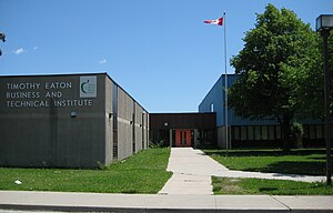
Timothy Eaton Business and Technical Institute
High school in Toronto, Ontario, Canada
Distance: Approx. 1579 meters
Latitude and longitude: 43.79393,-79.31084
Timothy Eaton Business and Technical Institute, formerly Timothy Eaton Secondary School is a defunct high school in the L'Amoreaux area of Toronto, Ontario, Canada originally operated by the Scarborough Board of Education. The school was named after Timothy Eaton, the founder of the now-defunct Eaton's department store chain. The site is now a residential development called Eaton on the Park Townhomes.
Toronto eSchool
Ontario secondary school - ossd online school
Distance: Approx. 1557 meters
Latitude and longitude: 43.76751,-79.29866
Toronto eSchool is an online high school and tutoring centre located in Toronto, Ontario, Canada. Toronto eSchool is inspected and approved by the Ontario Ministry of Education (BSID # 886520) to grant Ontario high school credits and the Ontario Secondary School Diploma (OSSD) itself since 2013. The tutoring centre offers both traditional tutoring and Maximize Your Success programs offered via seminars/webinars, workshops, academic programs, and test preparation classes.
Weather in this IP's area
clear sky
19 Celsius
19 Celsius
17 Celsius
20 Celsius
1017 hPa
83 %
1017 hPa
997 hPa
10000 meters
4.12 m/s
50 degree
07:00:26
19:22:03