Country:
 Canada
Region:
City:
Latitude and Longitude:
Time Zone:
Postal Code:
IP information under different IP Channel
ip-api
Country
Region
City
ASN
Time Zone
ISP
Blacklist
Proxy
Latitude
Longitude
Postal
Route
IPinfo
Country
Region
City
ASN
Time Zone
ISP
Blacklist
Proxy
Latitude
Longitude
Postal
Route
MaxMind
Country
Region
City
ASN
Time Zone
ISP
Blacklist
Proxy
Latitude
Longitude
Postal
Route
Luminati
Country
CARegion
on
City
nepean
ASN
Time Zone
America/Toronto
ISP
OXIO-ASN-01
Latitude
Longitude
Postal
db-ip
Country
Region
City
ASN
Time Zone
ISP
Blacklist
Proxy
Latitude
Longitude
Postal
Route
ipdata
Country
Region
City
ASN
Time Zone
ISP
Blacklist
Proxy
Latitude
Longitude
Postal
Route
Popular places and events near this IP address

Barrhaven
Community in Ontario, Canada
Distance: Approx. 356 meters
Latitude and longitude: 45.275,-75.75
Barrhaven is a suburb of Ottawa, Ontario, Canada. It is located about 17 km (11 mi) southwest of the city's downtown core. Prior to amalgamation with Ottawa in 2001, Barrhaven was part of the City of Nepean.

Nepean (federal electoral district)
Federal electoral district in Ontario, Canada
Distance: Approx. 551 meters
Latitude and longitude: 45.275,-75.758
Nepean is a federal electoral district in Ontario, Canada that was represented in the House of Commons of Canada from 1988 to 1997, and was reinstated during the 2012 electoral redistribution.
Nepean Township
Distance: Approx. 1205 meters
Latitude and longitude: 45.2686,-75.7667
Nepean Township is a former incorporated and now geographic township in Eastern Ontario, Canada, now part of the City of Ottawa. Originally known as Township D, it was established in 1792. In 1800, it became part of Carleton County and was incorporated as a township in 1850.
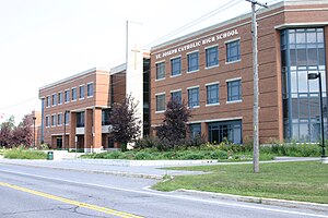
St. Joseph High School (Ottawa)
High school in Ottawa, Ontario, Canada
Distance: Approx. 1409 meters
Latitude and longitude: 45.262459,-75.740722
St. Joseph High School is a Roman Catholic high school in the Barrhaven neighbourhood of Ottawa, Ontario, Canada. It is run by the Ottawa Catholic School Board.
John McCrae Secondary School
Public high school in Ottawa, Ontario, Canada
Distance: Approx. 1119 meters
Latitude and longitude: 45.27916667,-75.7625
John McCrae Secondary School is a public secondary school in the Nepean district of Ottawa, Ontario, Canada. It supports grades 9-12. Built in 1999, it is the primary public high school in Barrhaven, replacing its predecessor, Confederation High School.

Barrhaven Centre station
Distance: Approx. 1018 meters
Latitude and longitude: 45.26611111,-75.7425
Barrhaven Centre station is the southerly terminus of the Southwest Transitway in the Barrhaven neighbourhood of Ottawa, Ontario, Canada. It is the main western terminus of rapid route 75 for trips not coming from or heading to Cambrian, as well as rapid route 99 for most trips not coming from or heading to Citigate. As part of the Stage 3 O-Train expansion to Barrhaven and Kanata, this station will be converted to light rail and will become the new western terminus for Line 1.

Strandherd station
Distance: Approx. 536 meters
Latitude and longitude: 45.27333333,-75.74555556
Strandherd Station is a transit station in Ottawa, Ontario. It opened on January 2, 2007 and contains a park and ride facility with over 300 parking spaces available. It is located northeast of the intersection of Strandherd Drive and the access to the Riocan Marketplace shopping area, where Barrhaven Centre Station and Marketplace Station opened in mid-2012.

Marketplace station
Transit station in Ottawa, Ontario, Canada
Distance: Approx. 788 meters
Latitude and longitude: 45.26972222,-75.74277778
Marketplace is a Southwest Transitway station in the Barrhaven neighbourhood of Ottawa, Ontario, Canada. The station is located at the Chapman Mills Marketplace shopping centre, an extensive commercial zone which contains big-box stores and department stores. A temporary bus terminal served the neighbourhood initially.
Longfields-Davidson Heights Secondary School
Public school in Canada
Distance: Approx. 1201 meters
Latitude and longitude: 45.27944444,-75.74083333
Longfields-Davidson Heights Secondary School is a public school in Barrhaven, a suburb of Ottawa, Ontario, Canada. It was founded in 2009.

Longfields station
Distance: Approx. 1477 meters
Latitude and longitude: 45.285,-75.74722222
Longfields is an Ottawa Transitway station in the Longfields neighbourhood of Ottawa, Ontario, Canada (Barrhaven). The station is located on a route that runs along the south side of the CNR railway line southwest from Fallowfield Station towards Strandherd Station. Located close to the station are École élémentaire catholique Pierre-Elliott-Trudeau, Mother Teresa High School and Longfields-Davidson Heights Secondary School.
Nepean (provincial electoral district)
Provincial electoral district in Ontario, Canada
Distance: Approx. 551 meters
Latitude and longitude: 45.275,-75.758
Nepean is a provincial electoral district that has existed from 1987 to 1999, and again since 2018. The riding was re-created federally with the 2012 redistribution process. That same process was followed by the Ontario government, meaning the provincial ridings follow a similar boundary division for the 2018 provincial election.
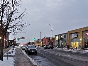
Chapman Mills Marketplace
Shopping mall
Distance: Approx. 838 meters
Latitude and longitude: 45.2703,-75.74185
Chapman Mills Marketplace is a shopping centre located in the Barrhaven neighbourhood of Ottawa, Ontario, Canada. The borders for the shopping district are Strandherd Drive to the north, Greenbank Road to the west, Longfields Drive to the east, and Chapman Mills Drive to the south. The centre consists of 20 buildings housing 66 stores and services including a grocery store (Loblaws, its anchor tenant), big box stores (Winners, Walmart), a cinema (Cineplex) and various restaurants.
Weather in this IP's area
broken clouds
20 Celsius
20 Celsius
17 Celsius
21 Celsius
1017 hPa
82 %
1017 hPa
1006 hPa
10000 meters
75 %
06:45:46
19:08:19