Country:
 Canada
Region:
City:
Latitude and Longitude:
Time Zone:
Postal Code:
IP information under different IP Channel
ip-api
Country
Region
City
ASN
Time Zone
ISP
Blacklist
Proxy
Latitude
Longitude
Postal
Route
IPinfo
Country
Region
City
ASN
Time Zone
ISP
Blacklist
Proxy
Latitude
Longitude
Postal
Route
MaxMind
Country
Region
City
ASN
Time Zone
ISP
Blacklist
Proxy
Latitude
Longitude
Postal
Route
Luminati
Country
CARegion
on
City
ottawa
ASN
Time Zone
America/Toronto
ISP
OXIO-ASN-01
Latitude
Longitude
Postal
db-ip
Country
Region
City
ASN
Time Zone
ISP
Blacklist
Proxy
Latitude
Longitude
Postal
Route
ipdata
Country
Region
City
ASN
Time Zone
ISP
Blacklist
Proxy
Latitude
Longitude
Postal
Route
Popular places and events near this IP address

R. H. Coats Building
Office building in Ontario, Canada
Distance: Approx. 473 meters
Latitude and longitude: 45.404817,-75.734189
The R.H. Coats Building is a government office building located in the Tunney's Pasture government office complex in Ottawa, Ontario, Canada. It is situated near the intersection of Holland Avenue and Scott Street, beside Tunney's Pasture Station. Named after Canada's first Dominion Statistician, Robert H. Coats (1874-1960), the R.H. Coats Building was completed in 1976 by the architectural firm Ogilvie and Hogg.

Protection of the Holy Virgin Memorial Church
Church in Ottawa, Ontario
Distance: Approx. 644 meters
Latitude and longitude: 45.407019,-75.727928
Protection of the Holy Virgin Memorial Church is a Russian Orthodox Church Outside Russia (ROCOR) church in Ottawa, Ontario, Canada. Designed by Ottawa architect George M. Moiseyev, who was also project architect for the Children's Hospital of Eastern Ontario, the church is located at 99 Stonehurst Avenue in the Mechanicsville area of Ottawa.

Tunney's Pasture station
Transit station in Ottawa, Canada
Distance: Approx. 447 meters
Latitude and longitude: 45.40388889,-75.735
Tunney's Pasture is the western O-Train light rail terminal train station in Ottawa, Ontario.

Tunney's Pasture
Government campus in Ottawa, Ontario, Canada
Distance: Approx. 733 meters
Latitude and longitude: 45.406194,-75.736978
Tunney's Pasture is a 49-hectare (121-acre) campus in the Canadian capital of Ottawa, Ontario, that is exclusively developed for federal government buildings. It is bordered by Scott Street to the south, Parkdale Avenue to the east, the Kichi Zibi Mikan to the north, and the Champlain Park neighbourhood to the west. While strictly speaking it is confined to this area, people living in the vicinity of it will often call the wider neighbourhood Tunney's Pasture.

Great Canadian Theatre Company
Distance: Approx. 195 meters
Latitude and longitude: 45.400067,-75.731839
The Great Canadian Theatre Company Mandate:"To foster, produce and promote excellent theatre that provokes examination of Canadian life and our place in the world."
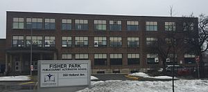
Fisher Park Public School
Middle school in Ottawa, Ontario, Canada
Distance: Approx. 703 meters
Latitude and longitude: 45.395188,-75.730745
Fisher Park Middle School is a public middle school in Ottawa, Ontario, Canada, offering English and French immersion education for grades seven and eight. The building is shared with the Summit Alternative School and the Fisher Park Community Centre.

Civic Hospital
Neighbourhood in Ottawa, Ontario, Canada
Distance: Approx. 936 meters
Latitude and longitude: 45.394,-75.725
Civic Hospital (French: Hôpital Civic) is a neighbourhood in Kitchissippi Ward in central Ottawa, Canada. It is named after the Ottawa Civic Hospital, which is located in the neighbourhood. Civic Hospital is bounded on the west by Island Park Drive, on the north by the Queensway, on the east by Railway Street and on the south by Carling Avenue.

Jean Talon Building
Federal office building in Ottawa, Ontario, Canada
Distance: Approx. 699 meters
Latitude and longitude: 45.406903,-75.734961
The Jean Talon Building is a federal government office building in Ottawa, Ontario, Canada. It forms part of the complex of three buildings, including the R. H. Coats Building and the Main Building, that houses the headquarters of Statistics Canada. Jean Talon was also the first intendant of the New France project Initially just named Census Building, it was renamed in honour of Jean Talon, the Intendant of New France who conducted the first census of what is now Canadian territory.

Main Building (Statistics Canada)
Building in Tunney's Pasture Driveway
Distance: Approx. 575 meters
Latitude and longitude: 45.405917,-75.734221
The Main Building, or Main Statistics Canada Building, is a four-storey federal government office building located in the Tunney's Pasture area of Ottawa, Ontario, Canada. It is connected on the north side by the Jean Talon Building and on the south side by the R. H. Coats Building. Most of its 1,700 occupants work for Statistics Canada.

Wellington Village
Neighbourhood in Ottawa, Ontario, Canada
Distance: Approx. 584 meters
Latitude and longitude: 45.39722222,-75.73472222
Wellington Village (formerly Island Park) is a neighbourhood in Kitchissippi Ward in the west end of Ottawa, Ontario, Canada. It is bounded on the north by Scott Street, on the west by Island Park Drive, on the south by The Queensway and on the east by Holland Avenue. The neighbourhood is covered by the Wellington Village Community Association, with the exception of Island Park Drive, which is covered by the Island Park Community Association.

Death of Abdirahman Abdi
Death of a Somali-Canadian, in Ottawa, Ontario
Distance: Approx. 829 meters
Latitude and longitude: 45.40647222,-75.7225
The death of Abdirahman Abdi, a Somali-Canadian, occurred on July 24, 2016, in the neighbourhood of Hintonburg in Ottawa, Ontario. Abdi died in an incident with the Ottawa Police Service.
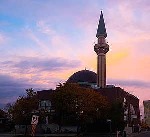
Ottawa Mosque
Mosque in Ottawa, Ontario, Canada
Distance: Approx. 857 meters
Latitude and longitude: 45.40147222,-75.74136111
The Ottawa Mosque (French: Mosquée d'Ottawa) is a mosque in Ottawa, Ontario, Canada.
Weather in this IP's area
broken clouds
20 Celsius
20 Celsius
18 Celsius
21 Celsius
1017 hPa
83 %
1017 hPa
1010 hPa
10000 meters
0.45 m/s
0.89 m/s
75 %
06:45:39
19:08:16