Country:
 Canada
Region:
City:
Latitude and Longitude:
Time Zone:
Postal Code:
IP information under different IP Channel
ip-api
Country
Region
City
ASN
Time Zone
ISP
Blacklist
Proxy
Latitude
Longitude
Postal
Route
IPinfo
Country
Region
City
ASN
Time Zone
ISP
Blacklist
Proxy
Latitude
Longitude
Postal
Route
MaxMind
Country
Region
City
ASN
Time Zone
ISP
Blacklist
Proxy
Latitude
Longitude
Postal
Route
Luminati
Country
CARegion
on
City
georgina
ASN
Time Zone
America/Toronto
ISP
OXIO-ASN-01
Latitude
Longitude
Postal
db-ip
Country
Region
City
ASN
Time Zone
ISP
Blacklist
Proxy
Latitude
Longitude
Postal
Route
ipdata
Country
Region
City
ASN
Time Zone
ISP
Blacklist
Proxy
Latitude
Longitude
Postal
Route
Popular places and events near this IP address

Chippewas of Georgina Island First Nation
Indian reserve in Ontario, Canada
Distance: Approx. 9778 meters
Latitude and longitude: 44.33333333,-79.28333333
The Chippewas of Georgina Island First Nation (Ojibwe: Waaseyaagmiing Anishinaabek) are an Ojibwa (or Anishinaabeg) people located on Georgina Island in Lake Simcoe, Ontario, Canada. In 2008, of the First Nation's registered population of 666 people, 181 lived on, and 485 lived outside, their reserve. As of 2020, the band has a total population of 923 members.

Sutton, Ontario
Unincorporated community in Ontario, Canada
Distance: Approx. 6962 meters
Latitude and longitude: 44.305,-79.35805556
Sutton is a suburban community located nearly 2 km south of Lake Simcoe in Ontario, Canada. The community was formerly a village but is now part of the Town of Georgina after amalgamation with it and North Gwillimbury in 1971. The Black River runs on the north end of the downtown.
Baldwin Airport
Airport in Baldwin, Ontario
Distance: Approx. 2663 meters
Latitude and longitude: 44.26722222,-79.34055556
Baldwin Airport (TC LID: CPB9) is a registered aerodrome located 0.3 nautical miles (0.56 km; 0.35 mi) east of Baldwin, Ontario, Canada. Baldwin Airport was home to the Parachute School of Toronto, which was the only skydiving club in Ontario that runs year round.

Sibbald Point Provincial Park
Provincial park in Ontario
Distance: Approx. 8665 meters
Latitude and longitude: 44.327,-79.322
Sibbald Point Provincial Park is a provincial park located in Sutton West, Ontario, Canada on the southern shores of Lake Simcoe, 70 kilometres (43 mi) north of Toronto. The park is located to the east of the vacation town of Jackson's Point, and The Briars Resort and Country Club which was still owned by the Sibbald family until it was sold in 2017. Sibbald Point Provincial Park has long sand beaches, sunny and shaded campsites, large grassy picnic areas and a forested hiking trail.
Sutton District High School
High school in Sutton West, Ontario
Distance: Approx. 6893 meters
Latitude and longitude: 44.30277778,-79.36194444
Sutton District High School is a public high school in the York Region District School Board with approximately 500 students. It is located in Sutton, Ontario, Canada and serves Grade 9 to 12 students. It is the primary secondary school for most communities in the town of Georgina, including Sutton West, Pefferlaw, and Udora.
Scott Township, Ontario
Distance: Approx. 9802 meters
Latitude and longitude: 44.18861111,-79.22944444
Scott, Ontario is a geographic township and former municipality now part of the Township of Uxbridge. The Township was surveyed in 1807 and was named for Thomas Scott (1746–1824), an Attorney-General and Chief Justice for Upper Canada. Scott Township was incorporated in 1850 and a Township hall was built in 1860.
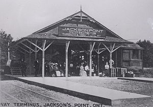
Jackson's Point
Unincorporated community in Ontario, Canada
Distance: Approx. 9719 meters
Latitude and longitude: 44.3186,-79.3926
Jackson's Point is a summer resort harbour located in the township of Georgina, on Lake Simcoe in Ontario, Canada. It was originally part of a naval land grant made to Captain William Bourchier (December 9, 1791 – January 22, 1844) in 1819 (Bourchier was commander of the Provincial Marine's Lake Huron establishment out of Penetanguishene Naval Yard. John Mills Jackson settled the land, which was first used as a wharf facility for schooners travelling Lake Simcoe.
Baldwin West Aerodrome
Airport in York Regional Municipality, Ontario
Distance: Approx. 4660 meters
Latitude and longitude: 44.2775,-79.36166667
Baldwin West Aerodrome (TC LID: CBW8) is a registered aerodrome located adjacent to Baldwin, Ontario, Canada.
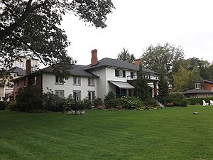
The Briars (Georgina)
Distance: Approx. 8774 meters
Latitude and longitude: 44.3217,-79.3618
The Briars is an Ontario lakeside resort located in the Jackson's Point area of Georgina, Ontario. Portions of the resort are protected by an Ontario Heritage Trust conservation easement. The Manor House and the Peacock House are the protected sections; this excludes the rear (west) elevation and the landscaped grounds to the east of the Manor House.
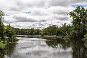
Black River (York Region)
River in Ontario, Canada
Distance: Approx. 8461 meters
Latitude and longitude: 44.3225,-79.34666667
The Black River is a river in the Regional Municipality of York and the Regional Municipality of Durham in Central Ontario, Canada. It is part of the Great Lakes Basin, and is a tributary of Lake Simcoe; the entire watershed is under the auspices of the Lake Simcoe Region Conservation Authority.
Chippewas of Georgina Island First Nation 33A
Indian reserve in Ontario, Canada
Distance: Approx. 9008 meters
Latitude and longitude: 44.32694444,-79.28722222
Chippewas of Georgina Island First Nation 33A is a First Nations reserve near the shores of Lake Simcoe. It is one of three reserves of the Chippewas of Georgina Island First Nation. It is an enclave within Georgina, Ontario, surrounded by the unincorporated community of Virginia Beach.

St. George's Anglican Church (Georgina, Ontario)
Church in Ontario, Canada
Distance: Approx. 9209 meters
Latitude and longitude: 44.33134,-79.33236
St. George's Anglican Church is a Neo-Gothic stone church located in Georgina listed under the Ontario Heritage Act. It is located in the community of Sibbald Point, and the current building was consecrated in 1877.
Weather in this IP's area
broken clouds
17 Celsius
17 Celsius
15 Celsius
18 Celsius
1017 hPa
67 %
1017 hPa
990 hPa
10000 meters
2.18 m/s
2.3 m/s
129 degree
51 %
07:00:22
19:22:15