Country:
 USA
USARegion:
City:
Latitude and Longitude:
Time Zone:
Postal Code:
IP information under different IP Channel
ip-api
Country
Region
City
ASN
Time Zone
ISP
Blacklist
Proxy
Latitude
Longitude
Postal
Route
IPinfo
Country
Region
City
ASN
Time Zone
ISP
Blacklist
Proxy
Latitude
Longitude
Postal
Route
MaxMind
Country
Region
City
ASN
Time Zone
ISP
Blacklist
Proxy
Latitude
Longitude
Postal
Route
Luminati
Country
USRegion
il
City
rushville
ASN
Time Zone
America/Chicago
ISP
CASSCOMM
Latitude
Longitude
Postal
db-ip
Country
Region
City
ASN
Time Zone
ISP
Blacklist
Proxy
Latitude
Longitude
Postal
Route
ipdata
Country
Region
City
ASN
Time Zone
ISP
Blacklist
Proxy
Latitude
Longitude
Postal
Route
Popular places and events near this IP address
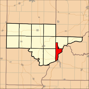
Schuyler County, Illinois
County in Illinois, United States
Distance: Approx. 7666 meters
Latitude and longitude: 40.16,-90.61
Schuyler County is a county in the U.S. state of Illinois. According to the 2020 census, it had a population of 6,902. Its county seat is Rushville.
Rushville, Illinois
City in Illinois, United States
Distance: Approx. 1876 meters
Latitude and longitude: 40.12111111,-90.56305556
Rushville is a city in Schuyler County, Illinois, United States. The population was 3,005 at the 2020 census. It is the county seat of Schuyler County.

Bainbridge Township, Schuyler County, Illinois
Township in Illinois, United States
Distance: Approx. 6272 meters
Latitude and longitude: 40.059291,-90.524558
Bainbridge Township is located in Schuyler County, Illinois. As of the 2010 census, its population was 639 and it contained 282 housing units.

Buena Vista Township, Schuyler County, Illinois
Township in Illinois, United States
Distance: Approx. 7047 meters
Latitude and longitude: 40.13944444,-90.61888889
Buena Vista Township is located in Schuyler County, Illinois. As of the 2010 census, its population was 1,849 and it contained 667 housing units.
Frederick Township, Schuyler County, Illinois
Township in Illinois, United States
Distance: Approx. 9565 meters
Latitude and longitude: 40.08138889,-90.43916667
Frederick Township is located in Schuyler County, Illinois. As of the 2010 census, its population was 176 and it contained 80 housing units.

Rushville Township, Schuyler County, Illinois
Township in Illinois, United States
Distance: Approx. 4817 meters
Latitude and longitude: 40.14805556,-90.50861111
Rushville Township is located in Schuyler County, Illinois. As of the 2020 census, its population was 2,419 and it contained 1,066 housing units.

Woodstock Township, Schuyler County, Illinois
Township in Illinois, United States
Distance: Approx. 8734 meters
Latitude and longitude: 40.05972222,-90.6175
Woodstock Township is located in Schuyler County, Illinois. As of the 2010 census, its population was 388 and it contained 177 housing units.

Phoenix Opera House Block
United States historic place
Distance: Approx. 1816 meters
Latitude and longitude: 40.12027778,-90.56277778
The Phoenix Opera House Block is a historic building in Rushville, Illinois. Built in 1882, the building housed commercial businesses on the first floor and an opera house on the second floor. The opera house hosted traveling performers and theater companies as well as local social events.

White Oak Hall
United States historic place
Distance: Approx. 2118 meters
Latitude and longitude: 40.10888889,-90.51916667
White Oak Hall, also known as White Oak School, is a historic building located near Rushville, Illinois, United States. The two-story school was built in 1874. The first floor of the building held the schoolroom, while the second floor was used as a meeting hall by the local chapter of The Grange.
Rushville-Industry High School
Comprehensive public high school in Rushville, Schuyler County, Illinois, USA
Distance: Approx. 2374 meters
Latitude and longitude: 40.128,-90.564
Rushville-Industry High School, or RIHS, is a public four-year high school located at 730 North Congress Street in Rushville, Illinois, a small city in Schuyler County, Illinois, in the Midwestern United States. RIHS serves the communities of Rushville, Industry, Browning, Camden, Frederick, and Littleton. The campus is located 25 miles south of Macomb, Illinois, and serves a mixed small city, village, and rural residential community.
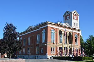
Schuyler County Courthouse (Illinois)
Local government building in the United States
Distance: Approx. 1915 meters
Latitude and longitude: 40.12055556,-90.56388889
The Schuyler County Courthouse is a government building in Rushville, the county seat of Schuyler County, Illinois, United States. Completed in 1882, it is the third courthouse in the county's history. Schuyler County was organized in 1825 from part of Pike County, and a commission chose a location in what is now far southern Rushville Township to become the new county seat.
Schuy-Rush Airport
Public Airport in Rushville, Illinois
Distance: Approx. 4049 meters
Latitude and longitude: 40.11722222,-90.59055556
Schuy-Rush Airport (FAA LID: 5K4) is a public-use airport located one-mile (1.6 km) west of Rushville, Illinois, United States. The airport is publicly owned by the City of Rushville. The closest major airport is Quincy Regional Airport-Baldwin Field, located 30 miles (48 km) west of Schuy-Rush.
Weather in this IP's area
overcast clouds
30 Celsius
30 Celsius
28 Celsius
30 Celsius
1016 hPa
49 %
1016 hPa
995 hPa
10000 meters
0.64 m/s
2.11 m/s
147 degree
97 %
06:44:34
19:09:19