Country:
 USA
USARegion:
City:
Latitude and Longitude:
Time Zone:
Postal Code:
IP information under different IP Channel
ip-api
Country
Region
City
ASN
Time Zone
ISP
Blacklist
Proxy
Latitude
Longitude
Postal
Route
IPinfo
Country
Region
City
ASN
Time Zone
ISP
Blacklist
Proxy
Latitude
Longitude
Postal
Route
MaxMind
Country
Region
City
ASN
Time Zone
ISP
Blacklist
Proxy
Latitude
Longitude
Postal
Route
Luminati
Country
USRegion
il
City
williamsville
ASN
Time Zone
America/Chicago
ISP
CASSCOMM
Latitude
Longitude
Postal
db-ip
Country
Region
City
ASN
Time Zone
ISP
Blacklist
Proxy
Latitude
Longitude
Postal
Route
ipdata
Country
Region
City
ASN
Time Zone
ISP
Blacklist
Proxy
Latitude
Longitude
Postal
Route
Popular places and events near this IP address
Sherman, Illinois
Village in Illinois, United States
Distance: Approx. 7915 meters
Latitude and longitude: 39.89222222,-89.60472222
Sherman is a village in Sangamon County, Illinois, United States. The population was 4,673 at the 2020 census. It is part of the Springfield, Illinois Metropolitan Statistical Area.

Spaulding, Illinois
Village in Illinois, United States
Distance: Approx. 9233 meters
Latitude and longitude: 39.86527778,-89.54166667
Spaulding is a village in Sangamon County, Illinois, United States. The population was 873 at the 2010 census. It is part of the Springfield, Illinois Metropolitan Statistical Area.

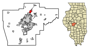
Williamsville, Illinois
Village in Illinois, United States
Distance: Approx. 422 meters
Latitude and longitude: 39.95083333,-89.55083333
Williamsville is a village in Sangamon County, Illinois, United States. The population was 1,476 at the 2010 census, and 1,491 at a 2018 estimate. It is part of the Springfield, Illinois Metropolitan Statistical Area.

Hurlbut Township, Logan County, Illinois
Township in Illinois, United States
Distance: Approx. 7233 meters
Latitude and longitude: 40.0125,-89.53611111
Hurlbut Township is located in Logan County, Illinois. As of the 2020 census, its population was 338 and it contained 136 housing units.

Williams Township, Sangamon County, Illinois
Township in Illinois, United States
Distance: Approx. 2580 meters
Latitude and longitude: 39.925,-89.545
Williams Township is located in Sangamon County, Illinois. As of the 2010 census, its population was 3,446 and it contained 1,332 housing units.

Fancy Prairie No. 3 Precinct, Menard County, Illinois
Place in Illinois, United States
Distance: Approx. 8566 meters
Latitude and longitude: 40.00361111,-89.61694444
Fancy Prairie No. 3 Precinct is located in Menard County, Illinois. The population was 192 at the 2000 census.
Mount Fulcher, Illinois
Unincorporated community in Illinois, United States
Distance: Approx. 5730 meters
Latitude and longitude: 39.99194444,-89.51222222
Mount Fulcher is an unincorporated community in Logan County, Illinois, United States. Mount Fulcher is located along Interstate 55 and former U.S. Route 66, northeast of Williamsville. "Mount" Fulcher is an end, or terminal moraine, a deposit of rocks and soil left by glaciers at the end of the last ice age.
Fancy Prairie, Illinois
Unincorporated community in Illinois, United States
Distance: Approx. 7068 meters
Latitude and longitude: 39.9975,-89.59944444
Fancy Prairie is an unincorporated community in Menard County, Illinois, United States. Fancy Prairie is 4 miles (6.4 km) northwest of Williamsville.
Barclay, Illinois
Unincorporated community in Illinois, United States
Distance: Approx. 8551 meters
Latitude and longitude: 39.87472222,-89.51777778
Barclay is an unincorporated community in Clear Lake and Williams townships, Sangamon County, Illinois, United States. Barclay is located on Illinois Route 54 and the Canadian National Railway, 1.3 miles (2.1 km) northeast of Spaulding.
Buffalo Hart, Illinois
Unincorporated community in Illinois, United States
Distance: Approx. 9339 meters
Latitude and longitude: 39.91388889,-89.4475
Buffalo Hart is an unincorporated community in northern Sangamon County in the U.S. state of Illinois. It is the population center of its own township, Buffalo Hart Township. Buffalo Hart was originally built in the 19th century, first as a frontier settlement based on a prairie grove, and then as a rural station stop on the Gilman, Clinton and Springfield Railroad twelve miles northeast of Springfield, Illinois, the state capital.
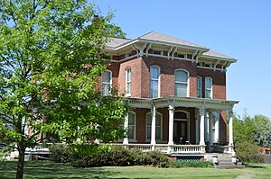
Price-Prather House
Historic house in Illinois, United States
Distance: Approx. 742 meters
Latitude and longitude: 39.95472222,-89.54638889
The Price-Prather House is a historic house located at the intersection of Main and Elkhart Streets in Williamsville, Illinois. The house was built in 1868 for livestock breeder James R. Price. The Italianate house features a multi-component slate roof, a bracketed and dentillated cornice, a wraparound front porch, and long arched windows with brick hoods.

Cornelius Flagg Farmstead
United States historic place
Distance: Approx. 8647 meters
Latitude and longitude: 39.89083333,-89.61583333
The Cornelius Flagg Farmstead is a historic farm located on Tipton School Road in Sherman, Illinois. Cornelius Flagg, a farmer and lumber businessman from Ohio, established the farm in the 1870s. The farmhouse, the farm's main building, is a two-story brick Italianate building.
Weather in this IP's area
clear sky
12 Celsius
11 Celsius
10 Celsius
13 Celsius
1033 hPa
81 %
1033 hPa
1011 hPa
10000 meters
2.41 m/s
2.83 m/s
180 degree
07:13:11
18:12:35