Country:
 USA
USARegion:
City:
Latitude and Longitude:
Time Zone:
Postal Code:
IP information under different IP Channel
ip-api
Country
Region
City
ASN
Time Zone
ISP
Blacklist
Proxy
Latitude
Longitude
Postal
Route
IPinfo
Country
Region
City
ASN
Time Zone
ISP
Blacklist
Proxy
Latitude
Longitude
Postal
Route
MaxMind
Country
Region
City
ASN
Time Zone
ISP
Blacklist
Proxy
Latitude
Longitude
Postal
Route
Luminati
Country
USRegion
il
City
havana
ASN
Time Zone
America/Chicago
ISP
CASSCOMM
Latitude
Longitude
Postal
db-ip
Country
Region
City
ASN
Time Zone
ISP
Blacklist
Proxy
Latitude
Longitude
Postal
Route
ipdata
Country
Region
City
ASN
Time Zone
ISP
Blacklist
Proxy
Latitude
Longitude
Postal
Route
Popular places and events near this IP address

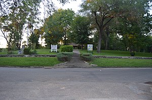
Havana, Illinois
City in Illinois, United States
Distance: Approx. 981 meters
Latitude and longitude: 40.295,-90.05666667
Havana is a city and the county seat of Mason County, Illinois, United States. The population was 2,963 at the 2020 census, a decline from the figure of 3,301 tabulated in 2010.
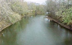
Spoon River
River in Illinois, United States
Distance: Approx. 839 meters
Latitude and longitude: 40.30694444,-90.07055556
The Spoon River is a 147-mile-long (237 km) tributary of the Illinois River in west-central Illinois in the United States. The river drains largely agricultural prairie country between Peoria and Galesburg. The river is noted for giving its name to the fictional Illinois town in the 1915 poetry work Spoon River Anthology by Edgar Lee Masters, who was from Lewistown, which is near the river.
Havana Water Tower
United States historic place
Distance: Approx. 619 meters
Latitude and longitude: 40.30055556,-90.05861111
The Havana Water Tower is a historic water tower which stands in Havana, Illinois. Built in 1889 and designed by St. Louis architect F. William Raider, it holds 50,000 gallons and was the town's only water supply until 1962.

Havana Public Library
Historic library in Havana, Illinois, US
Distance: Approx. 625 meters
Latitude and longitude: 40.29694444,-90.06
The Havana Public Library is a Carnegie library located at 201 W. Adams St. in Havana, Illinois. The library was built in 1902 to house Havana's library program, which began in 1896 and was previously kept in a room of the city hall.
Rockwell Mound
Archaeological site in Illinois, United States
Distance: Approx. 534 meters
Latitude and longitude: 40.304775,-90.06364722
Rockwell Mound has been listed on the National Register of Historic Places since 1987. The mound is located in Rockwell Park, on North Orange Street in the Illinois River city of Havana in Mason County. Rockwell Mound is one of the site that the Register has denoted as being "address restricted" because of its special sensitivity.

Waterford Township, Fulton County, Illinois
Township in Illinois, United States
Distance: Approx. 6401 meters
Latitude and longitude: 40.34694444,-90.11
Waterford Township is one of twenty-six townships in Fulton County, Illinois, USA. As of the 2020 census, its population was 173 and it contained 83 housing units.

Havana Township, Mason County, Illinois
Township in Illinois, United States
Distance: Approx. 5557 meters
Latitude and longitude: 40.27333333,-90.01083333
Havana Township is located in Mason County, Illinois, United States. As of the 2010 census, its population was 4,816 and it contained 2,295 housing units.
Emiquon National Wildlife Refuge
Distance: Approx. 3513 meters
Latitude and longitude: 40.325,-90.09166667
The Emiquon National Wildlife Refuge is a 11,122-acre (45.01 km2) wetland wildlife refuge located in Waterford Township in Fulton County, Illinois across the Illinois River from the town of Havana. Only 3,000 acres (12 km2) are currently managed by the U.S. Fish and Wildlife Service as part of the Illinois River National Wildlife and Fish Refuges Complex. It is in the Central forest-grasslands transition ecoregion.

Havana High School
Comprehensive public high school in Havana, Mason County, Illinois, USA
Distance: Approx. 1052 meters
Latitude and longitude: 40.296221,-90.05472
Havana High School, or HHS, is a public four-year high school located at 501 South McKinley Street in Havana, Illinois, a small town in Mason County, in the Midwestern United States. HHS is part of Havana Community Unit School District 126, which serves the communities of Bath, Havana, Kilbourne, and Topeka. The campus lies 45 miles southwest of Peoria, 45 miles northwest of Springfield, and serves a mixed small city, village, and rural residential community.
Lakewood, Mason County, Illinois
Unincorporated community in Illinois, United States
Distance: Approx. 6127 meters
Latitude and longitude: 40.24722222,-90.085
Lakewood is an unincorporated community in Havana Township, Mason County, Illinois, United States. Lakewood is located on County Route 1, 4 miles (6.4 km) south-southwest of Havana.

Scott Wike Lucas Bridge
Bridge in Havana, Illinois
Distance: Approx. 742 meters
Latitude and longitude: 40.29442,-90.070027
The Scott Wike Lucas Bridge is a bridge located in the community of Havana, Illinois. It carries U.S. Route 136 over the Illinois River. Named after a former politician, it was constructed in 1936 and reconstructed over 60 years later.

Ogden-Fettie Site
Archaeological site in Illinois, United States
Distance: Approx. 6338 meters
Latitude and longitude: 40.34083333,-90.11833333
The Ogden-Fettie Site is a prehistoric mound site located south of Lewistown in Fulton County, Illinois. The site was built during the Woodland period and is associated with the Havana Hopewell culture; it dates from roughly 100 B.C. to 400 A.D. The site consists of thirty-five mounds arranged in a crescent-shaped enclosure; the principal mound, located near the center, is 15 feet (4.6 m) high. A village site is located near the principal mound; it and four of the smaller mounds form a pentagonal-shaped enclosure.
Weather in this IP's area
few clouds
21 Celsius
20 Celsius
19 Celsius
21 Celsius
1022 hPa
46 %
1022 hPa
1006 hPa
10000 meters
1.42 m/s
1.79 m/s
273 degree
14 %
06:35:02
19:20:51