Country:
Region:
City:
Latitude and Longitude:
Time Zone:
Postal Code:
IP information under different IP Channel
ip-api
Country
Region
City
ASN
Time Zone
ISP
Blacklist
Proxy
Latitude
Longitude
Postal
Route
Luminati
Country
Region
pb
City
faisalabad
ASN
Time Zone
Asia/Karachi
ISP
Login.Me Pvt Ltd
Latitude
Longitude
Postal
IPinfo
Country
Region
City
ASN
Time Zone
ISP
Blacklist
Proxy
Latitude
Longitude
Postal
Route
db-ip
Country
Region
City
ASN
Time Zone
ISP
Blacklist
Proxy
Latitude
Longitude
Postal
Route
ipdata
Country
Region
City
ASN
Time Zone
ISP
Blacklist
Proxy
Latitude
Longitude
Postal
Route
Popular places and events near this IP address

Faisalabad District
District in Punjab, Pakistan
Distance: Approx. 6712 meters
Latitude and longitude: 31.41808333,73.077575
Faisalabad District (Lyallpur District until 1979) (Punjabi and Urdu: ضلع فیصل آباد) is one of the districts of Punjab province, Pakistan. According to the 1998 census of Pakistan it had a population of 3,029,547 of which almost 42% were in Faisalabad City. It is the third largest city of Pakistan after Karachi and Lahore.
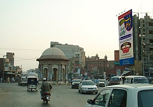
Clock Tower, Faisalabad
Clock tower monument in Faisalabad, Pakistan
Distance: Approx. 6856 meters
Latitude and longitude: 31.41867222,73.07913889
The Faisalabad Clock Tower (Punjabi, Urdu: فیصل آباد کلاک ٹاور), formerly known as the Lyallpur Clock Tower, is a clock tower in Faisalabad, Punjab, Pakistan, and is one of the oldest monuments still standing in its original state from the period of the British Raj. It was built in 1905 by the British, when they ruled much of South Asia during the early 20th century. The decision to build the clock tower on this spot was taken by the then Jhang deputy commissioner Sir James Lyall.

Qaisery Gate (Rail Bazar)
Distance: Approx. 7179 meters
Latitude and longitude: 31.41895,73.08399444
The Qaisery Gate was the gate into the eight markets with the Faisalabad Clock Tower at the centre. It was built in 1897 under the commission of the British Raj in the then newly-emerging city of Faisalabad, Punjab. The entrance itself is made of reinforced concrete and painted pale yellow and light brown to give it a Mughal look.
Batala Colony
Residential neighbourhood in Faisalabad, Punjab, Pakistan
Distance: Approx. 7104 meters
Latitude and longitude: 31.39951667,73.10041389
Batala Colony is a residential neighbourhood area in southern Faisalabad, Pakistan. It has various educational institutes, parks and markets.

Government College of Technology, Faisalabad
Public college in Faisalabad, Punjab, Pakistan
Distance: Approx. 3405 meters
Latitude and longitude: 31.3911,73.0605
The Government College of Technology, Samanabad, Faisalabad (GCT Faislaabad) is a public college located in Faisalabad, Punjab, Pakistan. It was established in 1966 as Government Polytechnic Institute and upgraded as Government College of Technology in 1981.
Roman Catholic Diocese of Faisalabad
Roman Catholic diocese in Pakistan
Distance: Approx. 5317 meters
Latitude and longitude: 31.35,72.9833
The Roman Catholic Diocese of Faisalabad (Lat: Dioecesis Faisalabadensis) is a diocese of the Latin Church of the Roman Catholic Church in Pakistan.
Jinnah Polytechnic Institute
Distance: Approx. 3414 meters
Latitude and longitude: 31.3584,73.0664
The Jinnah Polytechnic Institute (JPI) is a private polytechnic institute located in Faisalabad, Punjab, Pakistan.
Niamuana
Village in Punjab, Pakistan
Distance: Approx. 6460 meters
Latitude and longitude: 31.33888889,73.09027778
Niamuana is a village located in Faisalabad, Pakistan.
Government College University Faisalabad
Public university in Pakistan
Distance: Approx. 6106 meters
Latitude and longitude: 31.4161,73.07
The Government College University Faisalabad (colloquially known as GCUF) is a public university located in Faisalabad, Punjab, Pakistan.
Risalewala railway station
Railway station in Punjab, Pakistan
Distance: Approx. 1435 meters
Latitude and longitude: 31.3673,73.0191
Risalewala Railway Station (Urdu: رسالیوالہ ریلوے اسٹیشن) is located in Risalewala village, Faisalabad district of Punjab province of Pakistan. This railway station serves as the railway station for Faisalabad International Airport, as the airport is located in the Risalewala village area.
Samanabad railway station
Railway station in Punjab, Pakistan
Distance: Approx. 3545 meters
Latitude and longitude: 31.390425,73.063066
Samanabad Railway Station (Urdu: سمن آباد ریلوے اسٹیشن) is located in Samanabad area in Faisalabad city, Faisalabad district of Punjab province of the Pakistan. The station serves the areas of Samanabad, D type, Nisar colony and Novelty in Faisalabad city. Famous Government Science College Faisalabad lies in front of Samanabad Railway station.
Dasuha, Faisalabad
Distance: Approx. 6037 meters
Latitude and longitude: 31.31666667,73.03333333
Dasuha (Urdu: دسوہا) is a small town of Faisalabad district in the province of Punjab, Pakistan, approximately 13 km from the city of Faisalabad on the Samundri Road.
Weather in this IP's area
clear sky
32 Celsius
30 Celsius
32 Celsius
32 Celsius
1013 hPa
21 %
1013 hPa
993 hPa
10000 meters
1.91 m/s
1.7 m/s
99 degree
06:29:30
17:13:47
