Country:
 Brazil
Region:
City:
Latitude and Longitude:
Time Zone:
Postal Code:
IP information under different IP Channel
ip-api
Country
Region
City
ASN
Time Zone
ISP
Blacklist
Proxy
Latitude
Longitude
Postal
Route
IPinfo
Country
Region
City
ASN
Time Zone
ISP
Blacklist
Proxy
Latitude
Longitude
Postal
Route
MaxMind
Country
Region
City
ASN
Time Zone
ISP
Blacklist
Proxy
Latitude
Longitude
Postal
Route
Luminati
Country
BRRegion
pr
City
fozdoiguacu
ASN
Time Zone
America/Sao_Paulo
ISP
Plusnetfoz Provedor de Internet Ltda -ME
Latitude
Longitude
Postal
db-ip
Country
Region
City
ASN
Time Zone
ISP
Blacklist
Proxy
Latitude
Longitude
Postal
Route
ipdata
Country
Region
City
ASN
Time Zone
ISP
Blacklist
Proxy
Latitude
Longitude
Postal
Route
Popular places and events near this IP address
Triple Frontier
Tri-border area of Paraguay, Argentina and Brazil
Distance: Approx. 4474 meters
Latitude and longitude: -25.5925,-54.59305556
The Triple Frontier (Spanish: Triple Frontera, Portuguese: Tríplice Fronteira) is a tri-border area along the junction of Argentina, Brazil and Paraguay, where the Iguazú and Paraná rivers converge. Near the confluence are the cities of Puerto Iguazú (Argentina), Foz do Iguaçu (Brazil) and Ciudad del Este (Paraguay). This area is near Iguazú Falls and the Itaipu hydroelectric plant.

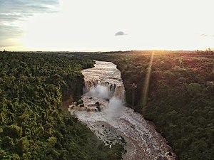
Iguazu River
River in Brazil and Argentina
Distance: Approx. 4459 meters
Latitude and longitude: -25.5925,-54.59166667
The Iguazu River (Portuguese: Rio Iguaçu [ˈʁi.u iɡwaˈsu], Spanish: Río Iguazú [ˈri.o iɣwaˈsu]), also called Rio Iguassu, (from the Guaraní í Guazú, literally "Big Water") is a river in Brazil and Argentina. It is an important tributary of the Paraná River. The Iguazu River is 1,320 kilometres (820 mi) long, with a drainage basin of 62,000 km2 (24,000 sq mi).
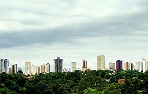
Foz do Iguaçu
Municipality in Sul, Brazil
Distance: Approx. 1403 meters
Latitude and longitude: -25.54,-54.5875
Foz do Iguaçu (Brazilian Portuguese pronunciation: [ˈfɔz du iɡwaˈsu]; "Iguazu River Mouth") is the Brazilian city on the border of Iguaçu Falls. The city is the 7th largest in the state of Paraná. The city's population is approximately 258,000.

Tancredo Neves Bridge
Bridge in Foz do Iguaçu to Puerto Iguazú
Distance: Approx. 4821 meters
Latitude and longitude: -25.588933,-54.56157
The Tancredo Neves Bridge, better known as Fraternity Bridge (Portuguese: Ponte da Fraternidade, Spanish: Puente de la Fraternidad) connects the Brazilian city of Foz do Iguaçu with the Argentine Puerto Iguazú, crossing over the Iguassu River. The idea of building the bridge had begun after the construction of the Friendship Bridge 1965, between Brazil and Paraguay. The Fraternity Bridge's construction started on January 13, 1982, and was officially inaugurated on November 29, 1985, and named after Brazilian politician Tancredo Neves.

Presidente Franco District
District and city in Alto Paraná, Paraguay
Distance: Approx. 3614 meters
Latitude and longitude: -25.53333333,-54.61666667
Presidente Franco (also simply known as Franco) is a district and city of the Alto Paraná Department, Paraguay. Aside from being the oldest city in Alto Paraná Department, it is a place of rich exports of fruits and vegetables. Also, Presidente Franco is well known for Saltos del Monday, a 45 m tall and 120 m wide waterfall, Eastern Paraguay.

Estadio Antonio Aranda
Distance: Approx. 3753 meters
Latitude and longitude: -25.52694444,-54.61194444
Estadio Antonio Aranda, known until 2013 as Estadio Tte. Cnel. Antonio Oddone Sarubbi, is a football stadium in the city of Ciudad del Este, Paraguay.

Roman Catholic Diocese of Foz do Iguaçu
Catholic ecclesiastical territory
Distance: Approx. 640 meters
Latitude and longitude: -25.5469,-54.5869
The Roman Catholic Diocese of Foz do Iguaçu (Latin: Dioecesis Iguassuensis) is a diocese located in the city of Foz do Iguaçu in the ecclesiastical province of Cascavel in Brazil.

Roman Catholic Diocese of Ciudad del Este
Roman Catholic diocese in Paraguay
Distance: Approx. 4363 meters
Latitude and longitude: -25.5179,-54.6079
The Roman Catholic Diocese of Ciudad del Este (Latin: Dioecesis Urbis Orientalis) is a diocese of the Roman Catholic Church based in the city of Ciudad del Este, in the Ecclesiastical Province of Asunción in Paraguay.
Saltos del Monday
Distance: Approx. 4509 meters
Latitude and longitude: -25.56194444,-54.63138889
The Municipal Park Monday [monˈdaɨ] and its main attraction – approximately 45 m (148 ft) tall and 120 m (390 ft) wide waterfall named Saltos del Monday – are located in the Presidente Franco District, Alto Paraná Department, Paraguay, located around 25°33'40.6"S latitude and 54°38'00.1"W longitude, occupying an area of 1.6 hectares (4 acres).

Argentina–Brazil border
International border
Distance: Approx. 4170 meters
Latitude and longitude: -25.59,-54.59
The Argentina–Brazil border is the line that limits the territories of the Argentine Republic and the Federative Republic of Brazil. It is approximately 1,224 km (761 mi) long. Starting at the confluence of Paraná and Iguaçu rivers, it passes through the Iguaçu Falls and follows the thalweg of that river to the mouth of Santo Antônio River, then running upstream the course of this river until its source.

Trinational Biodiversity Corridor
Distance: Approx. 4463 meters
Latitude and longitude: -25.592344,-54.593522
The Trinational Biodiversity Corridor (Portuguese: Corredor Trinacional de Biodiversidade) is a proposed ecological corridor that would link protected areas in the Alto Paraná Atlantic forests ecoregion in Brazil, Paraguay and Argentina.

Mesquita Omar Ibn Al-Khatab
Mosque in Paraná, Brazil
Distance: Approx. 3661 meters
Latitude and longitude: -25.52077778,-54.5785
The Omar Ibn Al-Khatab Mosque (Mesquita Foz Do Iguaçu) is a mosque located at Foz do Iguaçu, Paraná, Brazil. It is situated in the city near the Iguaçu Falls. The mosque was inaugurated on 23 March 1983 featuring a beautiful exterior design painted in uniform white color.
Weather in this IP's area
clear sky
25 Celsius
25 Celsius
25 Celsius
26 Celsius
1008 hPa
64 %
1008 hPa
991 hPa
10000 meters
2.06 m/s
20 degree
06:17:33
18:38:00