Country:
Region:
City:
Latitude and Longitude:
Time Zone:
Postal Code:
IP information under different IP Channel
ip-api
Country
Region
City
ASN
Time Zone
ISP
Blacklist
Proxy
Latitude
Longitude
Postal
Route
Luminati
Country
Region
ka
City
bengaluru
ASN
Time Zone
Asia/Kolkata
ISP
INFYNIX DATA SERVICES PRIVATE LIMITED
Latitude
Longitude
Postal
IPinfo
Country
Region
City
ASN
Time Zone
ISP
Blacklist
Proxy
Latitude
Longitude
Postal
Route
db-ip
Country
Region
City
ASN
Time Zone
ISP
Blacklist
Proxy
Latitude
Longitude
Postal
Route
ipdata
Country
Region
City
ASN
Time Zone
ISP
Blacklist
Proxy
Latitude
Longitude
Postal
Route
Popular places and events near this IP address

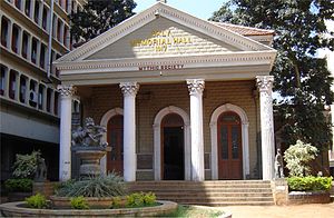
Daly Memorial Hall
Distance: Approx. 896 meters
Latitude and longitude: 12.97132778,77.58694722
The Daly Memorial Hall, is a heritage building located in Bangalore, Karnataka that houses the Mythic Society. The Mythic society, founded in 1909, is a pioneering institution of Catholic-Indic studies in South India. Daly Memorial Hall, built at a cost of INR 24,783, was inaugurated on 25 July 1917 by the Kanteerava Narasimharaja Wadiyar (the Yuvaraja of Mysore.
Government Pharmacy College, Bangalore
Distance: Approx. 575 meters
Latitude and longitude: 12.96210833,77.59063611
Government Pharmacy College, Bangalore is a pharmacy college located in Bangalore, India, run by the government of Karnataka. It was established in 1964 and is affiliated with the Rajiv Gandhi University of Health Sciences. It is ranked among the top ten pharmacy institutions in India.

Dharmaraya Swamy Temple
Hindu temple in Bangalore, India
Distance: Approx. 319 meters
Latitude and longitude: 12.9654,77.5834
Shri Dharmaraya Swamy Temple is one of the oldest and most famous Hindu temples of the city of Bangalore, in Karnataka, India.

Jain University
Private university in Bengaluru, India
Distance: Approx. 200 meters
Latitude and longitude: 12.9617,77.5849
Jain University, officially JAIN (Deemed-to-be University), is a private deemed university in Bengaluru, India. Originating from Sri Bhagawan Mahaveer Jain College of Engineering (SBMJCE), it was conferred the deemed-to-be-university status in 2009. In August 2019, Jain University opened its off campus in Kochi, Kerala.

Bangalore Town Hall
Town hall in Karnataka, India
Distance: Approx. 43 meters
Latitude and longitude: 12.96361111,77.58583333
Sir K. P. Puttanna Chetty Town Hall, locally commonly referred to as Bangalore Town Hall, is a neoclassical municipal building in Bangalore, India, named after the philanthropist and former president of Bangalore City Municipality, Sir K.P Puttanna Chetty.
Banappa Park
Public park in India
Distance: Approx. 546 meters
Latitude and longitude: 12.968152,77.586743
Banappa Park is a public park in Bangalore that has been used by various popular movements right from the days of Freedom Struggle or Indian independence movement. On average at least two rallies, attended by hundreds of people, are held every week at Banappa Park, off Hudson Circle. Many Leaders including Mahatma Gandhi have given inspiring talks and awareness speeches here in this park.

K. R. Market
Wholesale market in Bangalore, India
Distance: Approx. 868 meters
Latitude and longitude: 12.96361111,77.5775
K R Market (Krishnarajendra Market), also known as City Market, is the largest wholesale market dealing with commodities in Bangalore, India. It is named after Krishnarajendra Wodeyar, a former ruler of the princely state of Mysore. The market is located in the Kalasipalya area, adjacent to the Tipu Sultan's Summer Palace, on Mysore Road at its junction with Krishnarajendra Road.

Hudson Memorial Church, Bangalore
Church in Bangalore, India
Distance: Approx. 516 meters
Latitude and longitude: 12.9674008,77.5879109
The Hudson Memorial Church is located in the Bangalore Pete, Hudson Circle, surrounded by the Office of the Bangalore Corporation, Ulsoor Gate Police Station, Cubbon Park and Kanteerava Stadium. The church was established in 1904, and is a Kannada CSI church of the Bangalore Diocese. The church has around 4000 registered members and is named after Rev.
United Mission School
Government aided, private school in Bangalore, India
Distance: Approx. 225 meters
Latitude and longitude: 12.964219,77.587395
The United Mission School is located on Mission Road, Bangalore and is managed by the Church of South India. The school offers English medium education and is affiliated to the Karnataka Secondary Education Examination Board. The school has classes from Year 1 to Year 10.
Cubbonpet Assembly constituency
Former constituency in Karnataka, India
Distance: Approx. 675 meters
Latitude and longitude: 12.969272,77.583949
Cubbonpet was one of the vidhana sabha seats in the state assembly of Mysore, in India. It was part of Bangalore City Lok Sabha constituency.
Bangalore Lok Sabha constituency
Former constituency of the Indian parliament in Karnataka
Distance: Approx. 518 meters
Latitude and longitude: 12.967389,77.587959
Bangalore Lok Sabha constituency was a former Lok Sabha constituency in Mysore State in southern India.
Bangalore City Lok Sabha constituency
Former constituency of the Indian parliament in Karnataka
Distance: Approx. 518 meters
Latitude and longitude: 12.967389,77.587959
Bangalore City Lok Sabha constituency was a former Lok Sabha constituency in Mysore State in southern India.
Weather in this IP's area
mist
21 Celsius
21 Celsius
19 Celsius
21 Celsius
1013 hPa
85 %
1013 hPa
912 hPa
3000 meters
2.06 m/s
90 degree
40 %
06:16:25
17:50:52