Country:
 Canada
Region:
City:
Latitude and Longitude:
Time Zone:
Postal Code:
IP information under different IP Channel
ip-api
Country
Region
City
ASN
Time Zone
ISP
Blacklist
Proxy
Latitude
Longitude
Postal
Route
IPinfo
Country
Region
City
ASN
Time Zone
ISP
Blacklist
Proxy
Latitude
Longitude
Postal
Route
MaxMind
Country
Region
City
ASN
Time Zone
ISP
Blacklist
Proxy
Latitude
Longitude
Postal
Route
Luminati
Country
CARegion
bc
City
campbellriver
ASN
Time Zone
America/Vancouver
ISP
OXIO-ASN-01
Latitude
Longitude
Postal
db-ip
Country
Region
City
ASN
Time Zone
ISP
Blacklist
Proxy
Latitude
Longitude
Postal
Route
ipdata
Country
Region
City
ASN
Time Zone
ISP
Blacklist
Proxy
Latitude
Longitude
Postal
Route
Popular places and events near this IP address

Victoria, British Columbia
Capital city of British Columbia, Canada
Distance: Approx. 95 meters
Latitude and longitude: 48.42833333,-123.36472222
Victoria is the capital city of the Canadian province of British Columbia, on the southern tip of Vancouver Island off Canada's Pacific coast. The city has a population of 91,867, and the Greater Victoria area has a population of 397,237. The city of Victoria is the seventh most densely populated city in Canada with 4,406 inhabitants per square kilometre (11,410/sq mi).
Market Square, Victoria
Shopping mall
Distance: Approx. 110 meters
Latitude and longitude: 48.42787778,-123.36726111
Market Square is a town square and shopping centre located in the downtown core next to Chinatown in Victoria, British Columbia, Canada. There are more than 35 shops, restaurants, and clubs in the square.
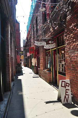
Fan Tan Alley
Alley in Victoria, British Columbia, Canada
Distance: Approx. 155 meters
Latitude and longitude: 48.429,-123.3679
Fan Tan Alley is an alley in the Chinatown neighbourhood of Victoria, British Columbia, Canada that is known for being the narrowest commercial street in North America, being less than 0.9 m (3.0 ft) wide at its narrowest point. It runs south from Fisgard Avenue to Pandora Avenue at the block between Government Street and Store Street. Named after the Chinese gambling game Fan-Tan, the alley was originally well known for opium factories that produced opium until it was made illegal in 1908.

McPherson Playhouse
Performing arts building in Victoria, British Columbia, Canada
Distance: Approx. 55 meters
Latitude and longitude: 48.42861111,-123.36666667
The McPherson Playhouse, known as The Mac, is a theatre and concert hall in Victoria, British Columbia, Canada. Part of the Centennial Square complex on the north side of downtown Victoria, adjacent to the intersection of Pandora and Government streets across from the CTV Vancouver Island studios and the Victoria City Hall, it was originally built as a Pantages Theatre in 1914. In the 1960s it was donated, with supporting funding for its renovation, to the people of Victoria by Thomas Shanks McPherson.

Victoria City Hall
Seat of local government in Victoria, British Columbia
Distance: Approx. 85 meters
Latitude and longitude: 48.42833333,-123.36485
Victoria City Hall is the city hall for Victoria, British Columbia, Canada. It is located at the corner of Douglas Street and Pandora Avenue adjacent to the CTV Vancouver Island studios and the McPherson Playhouse in downtown Victoria. It is home to the Victoria City Council.

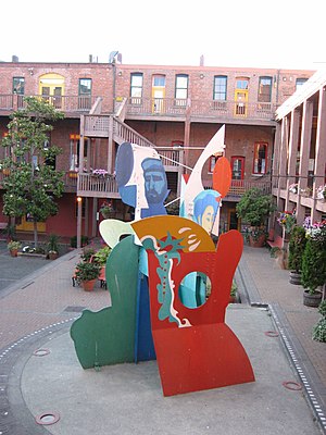
Centennial Square
Distance: Approx. 27 meters
Latitude and longitude: 48.42861111,-123.36583333
Centennial Square is a plaza in Victoria, British Columbia, Canada. It was built to celebrate the 100th anniversary of the incorporation of the City of Victoria. The Victoria Police Station, city hall and McPherson Playhouse are adjacent to the square.
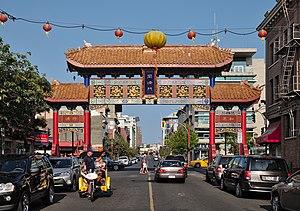
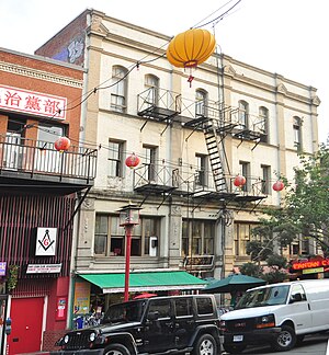
Gate of Harmonious Interest
Gate in Chinatown, Victoria, British Columbia
Distance: Approx. 147 meters
Latitude and longitude: 48.429379,-123.367334
The Gate of Harmonious Interest (Chinese: 同濟門; pinyin: Tóngjì mén) is a gate and cultural landmark located in Chinatown, Victoria, British Columbia. It spans Fisgard Street, west of Government Street. Erected in 1981, it was part of the revitalization efforts of Chinatown by the City of Victoria and the Chinese Consolidated Benevolent Association.

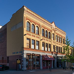
Doane Block
Distance: Approx. 174 meters
Latitude and longitude: 48.42695194,-123.36511389
The Doane Block is a historic building in Victoria, British Columbia, Canada.
Duck's Block
Distance: Approx. 154 meters
Latitude and longitude: 48.42704306,-123.36638
The Duck's Block is an historic building in Victoria, British Columbia, Canada.
Loo Tai Cho Building
Distance: Approx. 158 meters
Latitude and longitude: 48.42917889,-123.36778694
The Loo Tai Cho Building is an historic building in Victoria, British Columbia, Canada.

Gee Tuck Tong Benevolent Association Building
Clubhouse in Victoria, British Columbia
Distance: Approx. 127 meters
Latitude and longitude: 48.42954194,-123.36603389
The Gee Tuck Tong Benevolent Association Building is an historic building in Victoria, British Columbia, Canada.
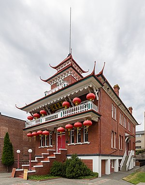
Chinese Consolidated Benevolent Association and Chinese Public School
Distance: Approx. 142 meters
Latitude and longitude: 48.42967194,-123.36579
The Chinese Consolidated Benevolent Association and Victoria Chinese Public School Chinese: (中華會館和域多利華僑公立學校) is a historic building is located in the downtown core of Victoria, British Columbia, Canada. The Chinese Public School was built in 1909 by the Chinese Consolidated Benevolent Association (CCBA) in response to the racial and cultural segregation imposed by the school board and government, which banned Chinese students from City schools until they spoke English. The school continues to provide Cantonese and Mandarin-language education.
Weather in this IP's area
few clouds
15 Celsius
15 Celsius
13 Celsius
17 Celsius
1015 hPa
80 %
1015 hPa
1014 hPa
10000 meters
4.12 m/s
250 degree
20 %
06:55:22
19:19:33