Country:
 Canada
Region:
City:
Latitude and Longitude:
Time Zone:
Postal Code:
IP information under different IP Channel
ip-api
Country
Region
City
ASN
Time Zone
ISP
Blacklist
Proxy
Latitude
Longitude
Postal
Route
IPinfo
Country
Region
City
ASN
Time Zone
ISP
Blacklist
Proxy
Latitude
Longitude
Postal
Route
MaxMind
Country
Region
City
ASN
Time Zone
ISP
Blacklist
Proxy
Latitude
Longitude
Postal
Route
Luminati
Country
CARegion
bc
City
portalberni
ASN
Time Zone
America/Vancouver
ISP
OXIO-ASN-01
Latitude
Longitude
Postal
db-ip
Country
Region
City
ASN
Time Zone
ISP
Blacklist
Proxy
Latitude
Longitude
Postal
Route
ipdata
Country
Region
City
ASN
Time Zone
ISP
Blacklist
Proxy
Latitude
Longitude
Postal
Route
Popular places and events near this IP address

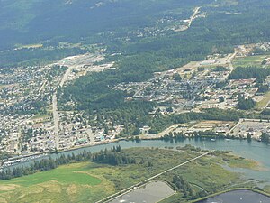
Port Alberni
City in British Columbia, Canada
Distance: Approx. 735 meters
Latitude and longitude: 49.23388889,-124.805
Port Alberni () is a city located on Vancouver Island in the province of British Columbia, Canada. The city lies within the Alberni Valley at the head of the Alberni Inlet, Vancouver Island's longest inlet. Port Alberni currently has a total population of 18,259.

Alberni Pacific Railway
Canadian heritage railway
Distance: Approx. 914 meters
Latitude and longitude: 49.23516,-124.81241
The Alberni Pacific Railway is a heritage railway originating in Port Alberni, British Columbia. The Alberni Pacific Railway returned to operations along the Port Alberni Waterfront in Summer of 2024, and is expected to run until the end of September. The Santa Train will also return in 2024 along with other popular events.
Port Alberni Water Aerodrome
Airport in Port Alberni, British Columbia
Distance: Approx. 1205 meters
Latitude and longitude: 49.23555556,-124.8175
Port Alberni Water Aerodrome (TC LID: CPW9) is located in Alberni Inlet, adjacent to Port Alberni, British Columbia, Canada.
CJAV-FM
Radio station in Port Alberni, British Columbia
Distance: Approx. 4427 meters
Latitude and longitude: 49.27777778,-124.78222222
CJAV-FM is a Canadian radio station broadcasting at 93.3 FM in Port Alberni, British Columbia. The station currently broadcasts an adult contemporary format branded on-air as 93.3 The Peak and is owned by Jim Pattison Group.

Alberni Mall
Shopping mall in British Columbia, Canada
Distance: Approx. 3049 meters
Latitude and longitude: 49.266,-124.7881
Alberni Mall is an outdoor shopping mall located in Port Alberni, British Columbia. Formerly an indoor mall until April 15, 2007, major renovation and redevelopment of the former mall complex began in the spring of that year, and it will most likely also be renamed as part of its updating.

Pacific Rim Shopping Centre
Distance: Approx. 3266 meters
Latitude and longitude: 49.2673,-124.785
Pacific Rim Shopping Centre is an outdoor shopping centre in Port Alberni, British Columbia, formatted as a power centre. It is located on the north side of town at the intersection of Cherry Creek Road and Johnson Road where the latter becomes known as the Alberni Highway. Walmart, Tyler's No Frills (formerly Extra Foods) and Staples (formerly Staples Business Depot) comprise Pacific Rim Centre's three anchor tenants.

Alberni Valley
Valley in British Columbia, Canada
Distance: Approx. 1096 meters
Latitude and longitude: 49.25,-124.8
Alberni Valley is a broad valley located at the head of Alberni Inlet on Vancouver Island in British Columbia, Canada. It is home to Port Alberni, Sproat Lake and other outlining areas. The term is largely used as a synonym for Greater Port Alberni and adjoining communities but is used in a larger regional sense as well.
Alberni District Secondary School
High school in Port Alberni, British Columbia, Canada
Distance: Approx. 700 meters
Latitude and longitude: 49.24111111,-124.79305556
Alberni District Secondary School (ADSS), formerly known as Alberni District High School (ADHS), is the only secondary school in Port Alberni. It is a part of School District 70 Alberni.
Somass River
River in British Columbia, Canada
Distance: Approx. 1402 meters
Latitude and longitude: 49.24611111,-124.81972222
Somass River is a river on Vancouver Island, in the Canadian province of British Columbia. Its drainage basin is 1,412 square kilometres (545 sq mi) in size. The river's name comes from a Nuu-chah-nulth word meaning "washing".
Cox Lake (British Columbia)
Natural lake in Vancouver Island, British Columbia
Distance: Approx. 4669 meters
Latitude and longitude: 49.20691667,-124.76372222
Cox Lake is a lake located southeast of Port Alberni, British Columbia. It is named after the Cox family, who lived at Cape Beale lighthouse in the 1870s.
Weyerhaeuser Arena
Distance: Approx. 1938 meters
Latitude and longitude: 49.256,-124.79109
The Weyerhaeuser Arena is part of the Alberni Valley Multiplex, between the North Island College campus and the Bob Dailey Stadium in Port Alberni, British Columbia. It has twin ice sheets for hockey, figure skating and recreational skating but also has the capacity for concerts, conventions and other events. The arena has been the home rink of the Alberni Valley Bulldogs of the BCHL since 2002, various local minor league hockey teams, and the Mt.
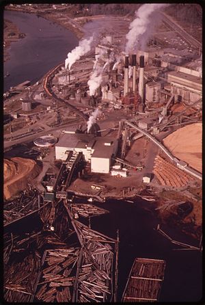
Port Alberni Mill
Paper mill in British Columbia, Canada
Distance: Approx. 1070 meters
Latitude and longitude: 49.2481,-124.8112
Port Alberni Mill is a paper mill located in the Canadian town of Port Alberni, British Columbia, on the edge of the Alberni Inlet. Part of Paper Excellence, the mill has two paper machines which produce 336,000 tonnes. Port Alberni Mill produces directory, lightweight coated paper, and specialty papers.
Weather in this IP's area
overcast clouds
18 Celsius
18 Celsius
16 Celsius
19 Celsius
1015 hPa
73 %
1015 hPa
1013 hPa
10000 meters
0.89 m/s
1.34 m/s
23 degree
99 %
07:00:49
19:25:34