Country:
 Canada
Region:
City:
Latitude and Longitude:
Time Zone:
Postal Code:
IP information under different IP Channel
ip-api
Country
Region
City
ASN
Time Zone
ISP
Blacklist
Proxy
Latitude
Longitude
Postal
Route
IPinfo
Country
Region
City
ASN
Time Zone
ISP
Blacklist
Proxy
Latitude
Longitude
Postal
Route
MaxMind
Country
Region
City
ASN
Time Zone
ISP
Blacklist
Proxy
Latitude
Longitude
Postal
Route
Luminati
Country
CARegion
ab
City
edmonton
ASN
Time Zone
America/Edmonton
ISP
OXIO-ASN-01
Latitude
Longitude
Postal
db-ip
Country
Region
City
ASN
Time Zone
ISP
Blacklist
Proxy
Latitude
Longitude
Postal
Route
ipdata
Country
Region
City
ASN
Time Zone
ISP
Blacklist
Proxy
Latitude
Longitude
Postal
Route
Popular places and events near this IP address

Commonwealth Stadium
Multiuse stadium in Edmonton, Alberta, Canada
Distance: Approx. 629 meters
Latitude and longitude: 53.55833333,-113.475
Commonwealth Stadium is an open-air, multipurpose stadium located in the McCauley neighbourhood of Edmonton, Alberta, Canada. It has a seating capacity of 56,302, making it the largest open-air stadium in Canada. Primarily used for Canadian football, it also hosts athletics, soccer, rugby union and concerts.

Clarke Stadium
Stadium in Edmonton, Alberta, Canada
Distance: Approx. 383 meters
Latitude and longitude: 53.55722222,-113.47833333
Clarke Stadium is a multipurpose facility located in Edmonton, Alberta, Canada. The stadium was originally built for Canadian football. Over the years different sports have participated at the site.
Edmonton (provincial electoral district)
Defunct provincial electoral district in Alberta, Canada
Distance: Approx. 825 meters
Latitude and longitude: 53.55,-113.49
The Edmonton provincial electoral district also known as Edmonton City from 1905 to 1909, was a provincial electoral district in Alberta, Canada mandated to return members to the Legislative Assembly of Alberta from 1905 to 1917 and again from 1921 to 1959. The Edmonton, Alberta electoral district was created when Alberta became a province, replacing the territorial electoral district of the same name. It existed in two incarnations from 1905 - 1913 and again from 1921 - 1959, with the city (small as it was in former times) broken up into separate single-member constituencies in the other time-periods.

Edmonton Public Schools
Public school division in Edmonton, Alberta, Canada
Distance: Approx. 807 meters
Latitude and longitude: 53.55472222,-113.49583333
Edmonton Public Schools (legally Edmonton School Division) is the largest public school division in Edmonton, the second largest in Alberta, and the sixth largest in Canada. The division offers a variety of alternative and special needs programs, and many are offered in multiple locations to improve accessibility for students. As a public school division, Edmonton Public Schools accepts all students who meet the age and residency requirements set out in provincial legislation.
Edmonton-Norwood
Defunct provincial electoral district in Alberta, Canada
Distance: Approx. 556 meters
Latitude and longitude: 53.56,-113.49
Edmonton-Norwood was a provincial electoral district in Alberta, Canada, mandated to return a single member to the Legislative Assembly of Alberta using the first past the post method of voting from 1959 to 2004.

Stadium station (Edmonton)
Light rail station in Canada
Distance: Approx. 954 meters
Latitude and longitude: 53.56,-113.47083333
Stadium station is an Edmonton LRT station in Edmonton, Alberta, Canada. It serves the Capital Line. It is a ground-level station located at 111 Avenue and 84 Street, next to Commonwealth Stadium and Clarke Stadium.
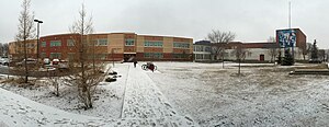
Victoria School of the Arts
School in Edmonton, Alberta, Canada
Distance: Approx. 863 meters
Latitude and longitude: 53.55361111,-113.49611111
Victoria School of the Arts (formerly Victoria School of Performing and Visual Arts) is a public school in Edmonton, Alberta, Canada operated by Edmonton Public Schools, offering students from kindergarten through grade 12 an International Baccalaureate aligned, arts-focused education, and is recognized as one of the top arts-focused schools in North America.

Royal Alexandra Hospital (Edmonton)
Hospital in Edmonton, Alberta
Distance: Approx. 846 meters
Latitude and longitude: 53.5574,-113.4967
The Royal Alexandra Hospital (RAH) is a large and long serving hospital in the Canadian province of Alberta. Operated by Alberta Health Services and located north of Edmonton's downtown core, the Royal Alexandra serves a diverse community stretching from Downtown Edmonton to western and northern Canada. The total catchment area for the RAH is equivalent to 1/3 of Canada's land mass, stretching north from Downtown Edmonton to enpass both the Northwest Territories and Yukon territory, and stretching as far west as British Columbia's pacific coast.
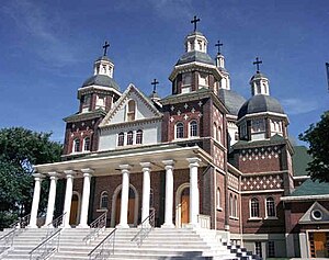
St. Josaphat Cathedral
Ukrainian Greek Catholic cathedral in Canada
Distance: Approx. 444 meters
Latitude and longitude: 53.5544,-113.4897
St. Josaphat Cathedral is a Ukrainian Catholic cathedral in McCauley, Edmonton, Alberta, one of the best examples of Byzantine Rite church architecture in Canada. It is the seat of the Ukrainian Catholic Eparchy of Edmonton, and has been a cathedral (the seat of a bishop) since 1948.
Edmonton-Sherwood Park (provincial electoral district)
Defunct provincial electoral district in Alberta, Canada
Distance: Approx. 556 meters
Latitude and longitude: 53.56,-113.49
Edmonton-Sherwood Park was a provincial electoral district in Alberta, Canada, mandated to return a single member to the Legislative Assembly of Alberta using the first past the post method of voting from 1979 to 1986.

Sacred Heart Church of the First Peoples
Church in Edmonton, Alberta
Distance: Approx. 271 meters
Latitude and longitude: 53.555,-113.48722222
The Sacred Heart Church of the First Peoples is a Roman Catholic church in Edmonton, Alberta. Opened as the Sacred Heart Church in 1913 to serve the city's rapidly growing population, Sacred Heart has been a historic "nursery" for many of Edmonton's immigrant Catholic parishes. In 1991, facing an aging congregation and declining weekly attendance, the parish's inner-city location was seen as an opportunity to serve Edmonton's growing urban Indigenous population.
Latta Bridge
Bridge in Alberta, Canada
Distance: Approx. 945 meters
Latitude and longitude: 53.55043,-113.47402
Latta Bridge is a road bridge in Edmonton, Alberta, Canada. It carries Jasper Avenue over the Latta Ravine, between 90 Street and 91 Street. The original bridge, a wooden trestle, was constructed in 1911, by its namesake, David Latta, who was a businessman and an alderman in Edmonton.
Weather in this IP's area
scattered clouds
17 Celsius
16 Celsius
14 Celsius
17 Celsius
1006 hPa
55 %
1006 hPa
931 hPa
10000 meters
2.57 m/s
320 degree
38 %
07:13:46
19:42:06