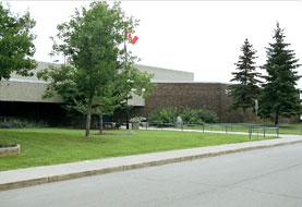
Country:
 Canada
Region:
City:
Latitude and Longitude:
Time Zone:
Postal Code:
IP information under different IP Channel
ip-api
Country
Region
City
ASN
Time Zone
ISP
Blacklist
Proxy
Latitude
Longitude
Postal
Route
IPinfo
Country
Region
City
ASN
Time Zone
ISP
Blacklist
Proxy
Latitude
Longitude
Postal
Route
MaxMind
Country
Region
City
ASN
Time Zone
ISP
Blacklist
Proxy
Latitude
Longitude
Postal
Route
Luminati
Country
CARegion
ab
City
edmonton
ASN
Time Zone
America/Edmonton
ISP
OXIO-ASN-01
Latitude
Longitude
Postal
db-ip
Country
Region
City
ASN
Time Zone
ISP
Blacklist
Proxy
Latitude
Longitude
Postal
Route
ipdata
Country
Region
City
ASN
Time Zone
ISP
Blacklist
Proxy
Latitude
Longitude
Postal
Route
Popular places and events near this IP address

Edmonton-Mill Woods (provincial electoral district)
Provincial electoral district in Alberta, Canada
Distance: Approx. 1903 meters
Latitude and longitude: 53.46,-113.43
Edmonton-Mill Woods is a provincial electoral district in Alberta, Canada. It is one of 87 current electoral districts mandated to return a single member to the Legislative Assembly of Alberta using the first past the post method of voting. This urban district is located in south central Edmonton was created in the 1979 boundary redistribution from Edmonton-Avonmore.
Kisêwâtisiwin School
Public school in Edmonton, Alberta, Canada
Distance: Approx. 1938 meters
Latitude and longitude: 53.445,-113.453
kisêwâtisiwin School is a junior high school in Edmonton, Alberta, Canada, located in the Knottwood community. In 2006, Today's Parent named the school one of the top 40 elementary and junior high schools in Canada.

Mill Woods Town Centre
Shopping mall
Distance: Approx. 1934 meters
Latitude and longitude: 53.45611111,-113.43111111
Mill Woods Town Centre is a shopping centre located in south Edmonton, Alberta, Canada in the neighbourhood of Mill Woods. It contains service and retail including Canadian Tire, Shoppers Drug Mart. Some surrounding satellite stores are located in and around the mall's exterior properties.
Millwoods Christian School
K-12 school in Edmonton, Alberta (est. 1978)
Distance: Approx. 1518 meters
Latitude and longitude: 53.47555556,-113.46222222
Millwoods Christian School, located in southeast Edmonton, Alberta, Canada, is an alternative school in the Edmonton Public School System. With its campus situated in the neighbourhood of Tweddle Place in Mill Woods, it has been serving the community since 1978. The school opened as an independent school under the direction of Calvary Community Church, a non-denominational church in south Edmonton.
Holy Trinity Catholic High School (Edmonton)
10-12 school in Edmonton, Alberta (est. 1984)
Distance: Approx. 1159 meters
Latitude and longitude: 53.45722222,-113.44305556
Holy Trinity Catholic High School is a high school located in Edmonton, Alberta, Canada in the southern neighbourhood of Mill Woods. It borders the Public High School of J. Percy Page, and the multi-recreational Mill Woods Park.
St. Clement Elementary/Junior High School
Elementary/junior high school in Edmonton, Alberta, Canada
Distance: Approx. 1878 meters
Latitude and longitude: 53.44611111,-113.44944444
St. Clement Catholic Elementary/Junior High School is a Kindergarten to Gr.9 school in the Edmonton Catholic School District serving the Knottwood and Millhurst communities, bounded by 91st Street and 66th Street from 23rd Avenue south to the city limits of approximately 9th Avenue including Summerside and Ellerslie Crossing. Transportation services by bus are available.

Grey Nuns Community Hospital
Hospital in Alberta, Canada
Distance: Approx. 1926 meters
Latitude and longitude: 53.461826,-113.429443
The Grey Nuns Community Hospital is an acute care hospital located in the Mill Woods area of south Edmonton, Alberta, Canada. The Grey Nuns Community Hospital provides a full range of services including a 24-hour Emergency Department. The 14-bed tertiary palliative care unit is known for its delivery of care and teaching practices.

Mill Woods Park
Distance: Approx. 1577 meters
Latitude and longitude: 53.45611111,-113.43694444
Mill Woods Park or Mill Woods Sport Park is a large multi-recreational park located in the centre of Mill Woods, Edmonton, just to the west of Mill Woods Town Centre. It serves as the school fields for both Holy Trinity and J Percy Page High Schools. The park features picnic sites, water playground, small lake, paved walkways, sports field, and a skate park.
J. Percy Page High School
10-12 school in Edmonton, Alberta (est. 1984)
Distance: Approx. 1010 meters
Latitude and longitude: 53.45638889,-113.44666667
J. Percy Page High School is a high school located in Edmonton, Alberta, Canada in the southern neighbourhood of Mill Woods. It borders the Catholic High School of Holy Trinity, and the multi-recreational Mill Woods Park. The school offers many opportunities for students including an Advanced Placement (AP) program, CTS courses and a Registered Apprenticeship Program (R.A.P.).
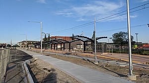
Mill Woods stop
Light rail station in Edmonton, Alberta, Canada
Distance: Approx. 1899 meters
Latitude and longitude: 53.45833333,-113.43055556
Mill Woods stop is a tram stop in the Edmonton LRT network in Edmonton, Alberta, Canada. It serves as the south terminus of the Valley Line. It is located on the south side of 28 Avenue NW, west of Hewes Way, between Tawa and Mill Woods Town Centre.

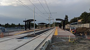
Grey Nuns stop
Light rail station in Edmonton, Alberta, Canada
Distance: Approx. 1596 meters
Latitude and longitude: 53.46277778,-113.43444444
Grey Nuns stop is a tram stop in the Edmonton LRT network in Edmonton, Alberta, Canada. It serves the Valley Line, and is located on the east side of 66 Street, north of 31 Avenue NW, between Kameyosek and Tawa. The stop was scheduled to open in 2020, but it officially opened on November 4, 2023.
Millbourne/Woodvale stop
Light rail station in Edmonton, Alberta, Canada
Distance: Approx. 1937 meters
Latitude and longitude: 53.475,-113.43888889
Millbourne/Woodvale stop is a tram stop in the Edmonton LRT network in Edmonton, Alberta, Canada. It serves the Valley Line, and is located on the east side of 66 Street, north of 38 Avenue NW, at the corners of Michaels Park, Greenview, Hillview, and Lee Ridge. The stop was scheduled to open in 2020.
Weather in this IP's area
few clouds
16 Celsius
15 Celsius
14 Celsius
17 Celsius
1006 hPa
55 %
1006 hPa
928 hPa
10000 meters
3.58 m/s
8.05 m/s
282 degree
20 %
07:13:43
19:41:57