Country:
 Canada
Region:
City:
Latitude and Longitude:
Time Zone:
Postal Code:
IP information under different IP Channel
ip-api
Country
Region
City
ASN
Time Zone
ISP
Blacklist
Proxy
Latitude
Longitude
Postal
Route
IPinfo
Country
Region
City
ASN
Time Zone
ISP
Blacklist
Proxy
Latitude
Longitude
Postal
Route
MaxMind
Country
Region
City
ASN
Time Zone
ISP
Blacklist
Proxy
Latitude
Longitude
Postal
Route
Luminati
Country
CARegion
ab
City
calgary
ASN
Time Zone
America/Edmonton
ISP
OXIO-ASN-01
Latitude
Longitude
Postal
db-ip
Country
Region
City
ASN
Time Zone
ISP
Blacklist
Proxy
Latitude
Longitude
Postal
Route
ipdata
Country
Region
City
ASN
Time Zone
ISP
Blacklist
Proxy
Latitude
Longitude
Postal
Route
Popular places and events near this IP address
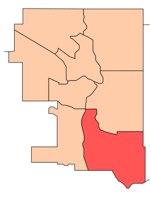
Calgary Southeast
Federal electoral district in Alberta, Canada
Distance: Approx. 2611 meters
Latitude and longitude: 50.95,-113.97
Calgary Southeast was a federal electoral district in Alberta, Canada, that was represented in the House of Commons of Canada from 1988 to 2015. The district was in the southeast part of the City of Calgary. It was bounded by the city limits to the south and east.
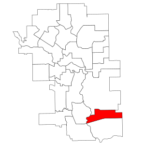
Calgary-Hays
Provincial electoral district in Alberta, Canada
Distance: Approx. 1579 meters
Latitude and longitude: 50.94,-113.98
Calgary-Hays is a provincial electoral district mandated to return one member to the Legislative Assembly of Alberta, Canada using the first past the post method of voting. The riding was formed in 2004, carved out of the Calgary-Shaw electoral district. The district is named after former Calgary mayor and Canadian Senator Harry Hays who represented the electoral district of Calgary South as a Member of Parliament.
McKenzie Lake, Calgary
Neighbourhood in Calgary, Alberta, Canada
Distance: Approx. 2333 meters
Latitude and longitude: 50.90777778,-113.98722222
McKenzie Lake is a residential neighbourhood in southeast Calgary, Alberta. The community was in development from the mid-1980s through to present. The area is bordered by Deerfoot Trail on the east, Stoney Trail on the south, Fish Creek Provincial Park on the west, and 130th Ave SE on the north.
McKenzie Towne, Calgary
Neighbourhood in Calgary, Alberta, Canada
Distance: Approx. 1466 meters
Latitude and longitude: 50.91361111,-113.96916667
McKenzie Towne is a master planned residential neighbourhood in the southeast of Calgary, Alberta being developed by Carma Developers LP (now Brookfield Residential Properties Inc.). The community is bordered on the west by Deerfoot Trail, on the south by Stoney Trail, on the east by 52 St. S.E., and to the north by the South Trail regional commercial centre along 130 Ave.
Copperfield, Calgary
Neighbourhood in Calgary, Alberta, Canada
Distance: Approx. 2792 meters
Latitude and longitude: 50.91083333,-113.94166667
Copperfield is a neighbourhood in the southeast quadrant of Calgary, Alberta. The neighbourhood is bounded by 52nd St. to the west, Stoney Trail to the south, and the neighbourhood of New Brighton to the north.
Douglasdale/Douglasglen
Neighbourhood in Calgary, Alberta, Canada
Distance: Approx. 1965 meters
Latitude and longitude: 50.94083333,-113.98916667
Douglasdale is a residential neighbourhood in the southeast quadrant of Calgary, Alberta. It is bounded by 114 Avenue S to the north, 130 Avenue S to the south, Deerfoot Trail to the east and the Bow River to the west. The Fish Creek Provincial Park borders the neighbourhood to the west.
Deer Ridge, Calgary
Neighbourhood in Calgary, Alberta, Canada
Distance: Approx. 2917 meters
Latitude and longitude: 50.92638889,-114.01416667
Deer Ridge is a residential neighbourhood in the southeast quadrant of Calgary, Alberta. It is located in the Bow River valley, and is bounded to the north by Canyon Meadows Drive, to the east by Deercliff Road and the Bow River, to the south by Deerfield Circle and the community of Deer Run and to the west by Bow Bottom Trail. Fish Creek Provincial Park is located immediately east.
Deer Run, Calgary
Neighbourhood in Calgary, Alberta, Canada
Distance: Approx. 2682 meters
Latitude and longitude: 50.91805556,-114.00833333
Deer Run is a residential neighbourhood in the southeast quadrant of Calgary, Alberta. It is located in a bend of the Bow River, and is surrounded to the east and south by the Fish Creek Provincial Park. It is bounded to the north by North Deersaxon Circle and the community of Deer Ridge and to the west by Bow Bottom Trail.
Queensland, Calgary
Neighbourhood in Calgary, Alberta, Canada
Distance: Approx. 3744 meters
Latitude and longitude: 50.93805556,-114.02277778
Queensland is a residential neighbourhood in the southeast quadrant of Calgary, Alberta. It is bounded to the north by the community of Diamond Cove, to the east by the Bow River and Fish Creek Provincial Park, to the south by Canyon Meadows Drive, and to the west by Bow Bottom Trail. The land was annexed to the City of Calgary in 1961 and Queensland was established in 1973.
Cranston, Calgary
Neighbourhood in Calgary, Alberta, Canada
Distance: Approx. 3904 meters
Latitude and longitude: 50.89222222,-113.98361111
Cranston is a master planned residential community in the southeast quadrant of Calgary, Alberta by Carma Developments who started development of the farming land in 1999. Cranston contains a wide range of single family and multi family residential as well as commercial property. It has two public elementary schools and one separate board K-9 school, as well as Century Hall - a private Cranston residents recreation facility.

New Brighton, Calgary
Neighbourhood in Calgary, Alberta, Canada
Distance: Approx. 1525 meters
Latitude and longitude: 50.92138889,-113.9525
New Brighton is a master–planned residential neighbourhood developed in the southeast of Calgary, Alberta. Located east of 52nd Street SE and south of 130th Ave and McIvor Boulevard to the south. The community contains a variety of single family and multi-family homes as well as a private residents' association recreation facility called the New Brighton Club.

Race City Motorsport Park
Distance: Approx. 3445 meters
Latitude and longitude: 50.943692,-113.931656
Race City Motorsport Park, also known as Race City, was a multi-track auto racing facility located in Calgary, Alberta, Canada. The facility featured a ¼ mile dragstrip, a 3.2 km (2.0 mi) 11-turn road course, and a ½ mile paved short oval. The Race City grounds, known as Race City Speedway, was a regular host of Warped Tour.
Weather in this IP's area
overcast clouds
16 Celsius
16 Celsius
14 Celsius
17 Celsius
1007 hPa
61 %
1007 hPa
892 hPa
10000 meters
2.86 m/s
4.63 m/s
337 degree
100 %
07:16:50
19:42:57